I object to a vote being taken at the end of July to put the master plan for the brewery site on a statutory basis before any proper archaeological survey. This is completely putting the cart before...
3.1 Masterplan Area Context
Closed23 Jun, 2015, 7:00am - 21 Jul, 2015, 6:00pm
3.1.1 Description of the Study Area
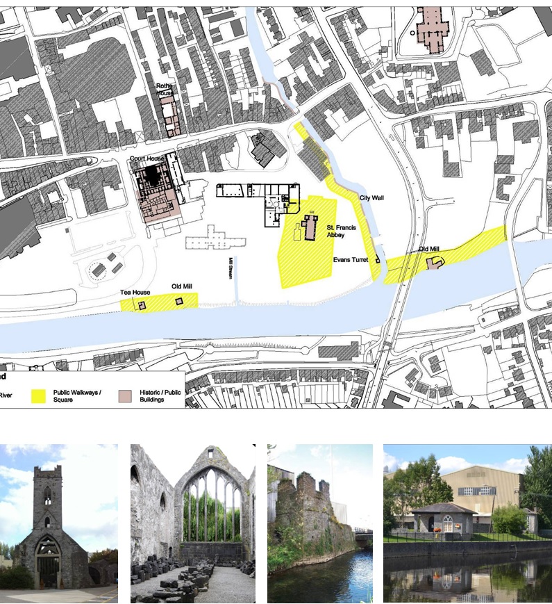
The masterplan site comprises an area of 8.25 hectares (20.4 acres) and lies at the heart of the medieval core of Kilkenny City Centre. The topography of the site is generally flat with the ground gently sloping from west to east down to the river. The ground is generally level from south to north, with the ground levels rising at the junction with Greens Bridge.
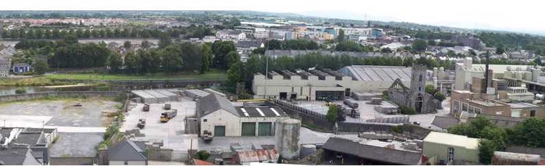
The River Bregagh and sections of the old city wall traverse the site on an east west axis and effectively subdivide the site into two distinct quarters of very different character. The southern quarter contains the majority of the existing buildings and is quite industrial in nature with large industrial and warehouse buildings surrounded by extensive concrete marshalling yards. The northern quarter is less developed and was primarily used by the Brewery for vehicular parking, truck washing, etc.
The most northerly section of the site is a parcel of land known as Sweeney’s Orchard. This would best be described as a disused back lot. The site is bordered to the south by Bateman Quay and the Market Yard. To the west lies Parliament Street, containing many fine three storeys over basement Georgian buildings, Horse Barack Lane and Vicar Street with predominantly two storey residential terraced buildings. To the north lies some residential properties and industrial units which are accessed from Green Street. To the east is the River Nore.
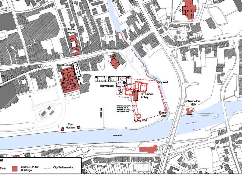
There are several existing heritage structure within the site. These are;
• St. Francis Abbey,
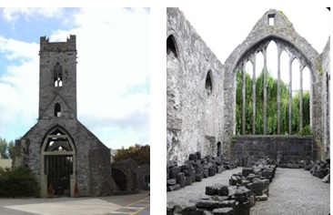
• The City Walls,
• Evan’s Turret
• Tea Houses
• Wall of the Bull Inn
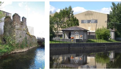
Due to the inaccessibility of the site these structures remain in reasonable condition. There are a further eight individual structures on the site. These vary in scale from single storey to 7 storeys. A detailed analysis of these buildings suggested that the majority of these structures are not suitable for reuse. However it was determined that the Brewhouse and Mayfair Buildings could be renovated for alternate uses.
3.1.2 Context of the Study Area
Kilkenny City Centre is characterized by its historic street and laneway network, the River Nore, its historical public buildings, and its two city centre bridges, Johns Bridge and Greens Bridge.
The masterplan site area is quite different in many ways from these characteristics. The southern quarter contains the majority of the existing buildings and is industrial in nature with large production and warehouse buildings surrounded by extensive concrete marshalling yards. The River Nore, the River Bregagh and the Old City Walls are hidden by these structures.
St. Francis Abbey Brewery, due to its industrial nature, has for many years been separated from the city. It has been an impediment to creating a permeable city and has prevented the formation of linkages through the city.
Vehicular access to the site is restricted primarily to the main entrance from Parliament Street. A secondary vehicular access point lies on the southern boundary of the site to the rear of the Courthouse with access from Bateman Quay.
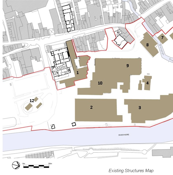
Keyplan:
1. Labs, Engineering, Cellar and Visitor Centre
2. Bottling Store
3. Kegging Store
4. St Francis Abbey
5. Truck Wash Garage
6. Car parking Shed
7. Hop store – Squash Court
8. The Mayfair
9. Brewhouse
10. Maturation Towers
11. Evans Turret& Line of Old City Wall
12. Pumping Station
3.1.3 Statutory Planning & Policy Framework
This section of the Abbey Creative Quarter Urban Design Framework Plan identifies the statutory planning context within which the Urban Design Framework for the Abbey Quarter Area is set.
Development and land use zoning aims, policies and objectives are determined by the higher ranking statutory development plans adopted by Kilkenny County Council which have been subject to Strategic Environmental Assessment and Appropriate Assessment. These local statutory plans in turn are guided by the strategic planning policies of the Regional Planning Guidelines and National Spatial Strategy.
The Kilkenny City & Environs Development Plan 2014-2020 is the most relevant reference document in relation to the implementation of strategic and local development policies and objectives at a local level within Kilkenny City. As a lower ranking non-statutory plan for a defined urban area, contained within the development boundary of the Kilkenny City & Environs Development Plan, this Urban Design Framework for the Abbey Creative Quarter Area will function primarily as a design guide for development within the plan area.
Kilkenny City and Environs Development 2014 - 2020
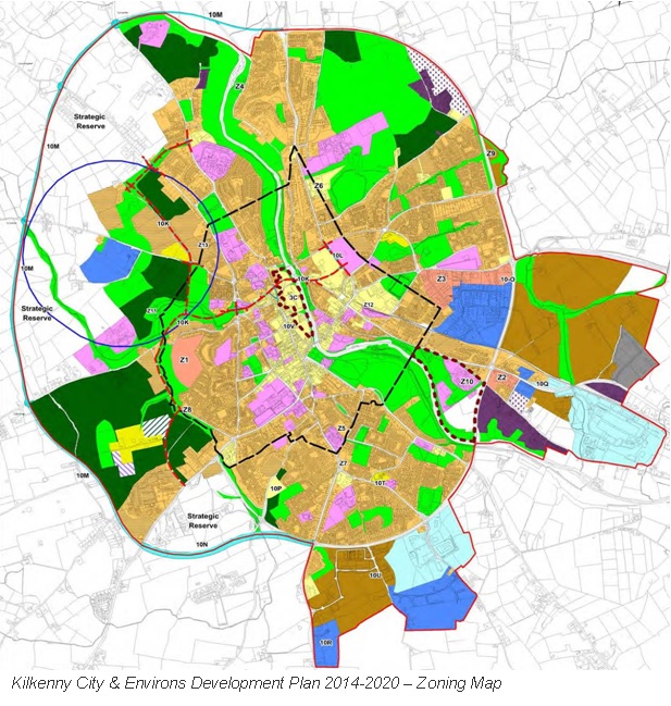
This masterplan/framework document is set within the context of the Kilkenny City and Environs Development 2014 - 2020.
The key issues identified as requiring to be addressed in Kilkenny City and Environs Development 2014 - 2020 Plan are as follows:
The key issues to be addressed in this Plan are as follows:
- Economic recovery; positioning of the city and county to avail of any economic upturn.
- Underpinning the settlement strategy for the city and compliance with the requirements of the Regional Planning Guidelines through the core strategy.
- Framework for development of Smithwick’s site.
- Continued protection of the natural and built heritage.
Objective 3C of the Kilkenny City and Environs Development 2014 - 2020 Plan states that it will be an objective of the Council to;
“ Prepare a Masterplan and Urban Design Framework for the Smithwicks Site and Bateman Quay during the lifetime of the development plan.”
Arising from an analysis of the issues identified in the Kilkenny City and Environs Development 2014 - 2020 Plan the following objectives were advanced through this masterplan;
- To advance the co-operation between Kilkenny Local Authorities, existing third level institutions and the proposed Technology University for the South East.
- To support employment creation, innovation and lifelong learning.
- To promote the sustainable development of the city.
- To provide the highest quality living environments possible.
- To guide the location and pattern of development whilst ensuring a relatively compact urban form is maintained.
- To promote balanced and sustainable economic development and employment by ensuring that a diverse range of economic sectors are developed.
- To develop an integrated transport strategy for the city linked to land use objectives, which facilitates access to a range of transport modes.
- To protect, conserve and enhance the built and natural heritage of the city.
- To promote the regeneration of the city centre and to protect and promote the city centre as the commercial and cultural focus for the city.
- To advance the redevelopment of the Bateman Quay site for civic and prime retail use.
- To provide a hierarchy of parks, open spaces and outdoor recreation areas and to use the river corridors of the River Nore, Breagagh and Pococke to provide open space for the city while having due consideration to their ecological sensitivity.
3.1.4 Site Analysis - Archaeology
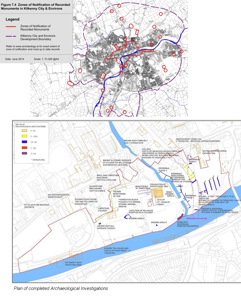
The Masterplan site is located within a Zone of Notification of Recorded Monuments. There are several National Monuments on the site; St.Francis Abbey, the City Wall and Evans Turret.
The Archaeological Policies of Kilkenny County Council, are articulated as follows within Kilkenny City and Environs Development Plan 2014 - 2020:
Objective 7H - Protect archaeological sites and monuments (including their setting), underwater archaeology, and archaeological objects, including those that are listed in the Record of Monuments and Places, and in the Urban Archaeological Survey of County Kilkenny or newly discovered sub‐surface and underwater archaeological remains.
Development Management Standards
Endeavour to preserve in situ all archaeological monuments, whether on land or underwater, listed in the Record of Monuments and Places (RMP), and any newly discovered archaeological sites, features, or objects by requiring that archaeological remains are identified and fully considered at the very earliest stages of the development process and that schemes are designed to avoid impacting on the archaeological heritage.
To require archaeological assessment, surveys, test excavation and/or monitoring for planning applications in areas of archaeological importance if a development proposal is likely to impact upon in‐situ archaeological monuments, their setting and archaeological remains.
Ensure that development within the vicinity of a Recorded Monument is sited and designed appropriately so that it does not seriously detract from the setting of the feature or its zone of archaeological potential. Where upstanding remains of a Recorded Monument exist a visual impact assessment may be required to fully determine the effect of any proposed development.
Require the retention of surviving medieval plots and street patterns and to facilitate the recording of evidence of ancient boundaries, layouts etc. in the course of development.
Safeguard the importance of significant archaeological or historic landscapes from developments that would unduly sever or disrupt the relationship, connectivity and/or inter‐visibility between sites.
Conservation Plans have been prepared for significant archaeological and architectural sites in Kilkenny city. These include the Kilkenny City Walls, Rothe House, and St. Mary’s Church and Graveyard.
Objective 7I - To facilitate and support the implementation of the existing (and any further) conservation plans.
A detailed Archaeological Strategy has been prepared for the Masterplan Area. The recommendations identified have been taken account of in the development of the Masterplan and have significantly impacted on the urban design.
3.1.5 Site Analysis - Views
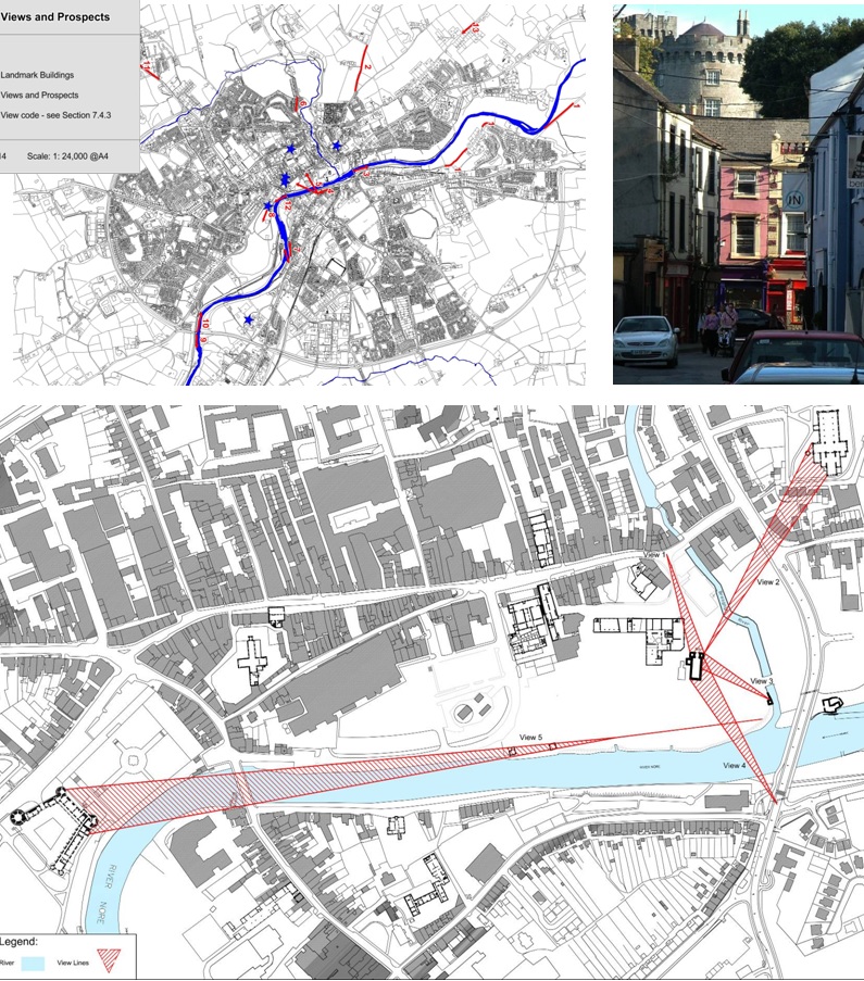
The Policies of Kilkenny County Council in relation to the protection of views are articulated as follows within Kilkenny City and Environs Development Plan 2014-2020:
There are a number of sites, areas and vantage points within the City and in the Environs, from which fine views of the City can be had, see Figure 7.5. There are also vantage points within the City from which particularly good views of the City’s most important public buildings and natural landscape features may be obtained. Of particular importance are views of and from the Castle, Cathedrals and the River Nore.
It is a policy of the Council to;
- Protect the views and prospects identified on Figure 7.5 by requiring new development or extensions to existing development to be designed and located so as not to have a significant impact on its character.
- Encourage street layouts in newly developed areas which create new vistas to existing and new landmarks, in particular within Brownfield sites.
 Noted views which relate to the Abbey Creative Quarter consist of;
- View of St. Mary’s Cathedral, Tholsel and St. Mary’s Church from No. 30‐35 Michael Street
- Panoramic view from Dublin Road/Windgap Hill area to River Nore and city skyline
- View of River Nore valley to east from Ossory Bridge
While not identified within the development plan the following views are design drivers for the Urban Framework Masterplan;
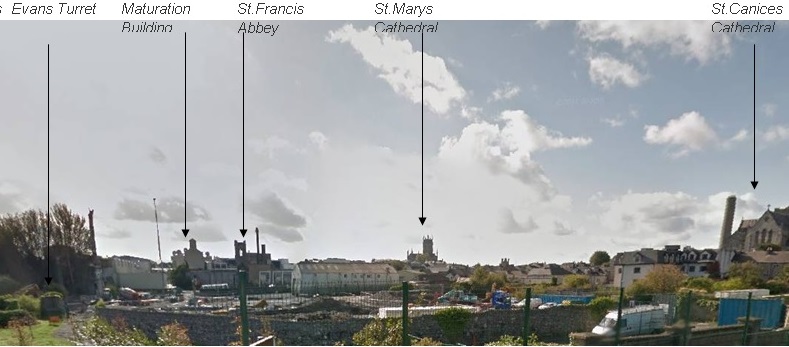
- View from Parliament Street to St.Francis Abbey
- View from St.Francis Abbey to the City Wall, Evans Turret and St.Canices Cathedral
- View from Evans Turret to Kilkenny Castle
- View from the Central Access Scheme to St.Francis Abbey
3.1.6 Site Analysis - Architectural Heritage
The Architectural Heritage Policies of Kilkenny County Council, are articulated as follows within Kilkenny City and Environs Development Plan 2014 - 2020:
- To have regard to the Architectural Heritage Protection Guidelines when assessing proposals for development affecting a protected structure.
- To promote principles of best practice in conservation in terms of use of appropriate materials and repair techniques through the administration of the Structures at Risk Fund, provided by the Department of Arts, Heritage and the Gaeltacht.
- To require the sympathetic retention, reuse and rehabilitation of Protected Structures and their settings.
- To require an architectural impact assessment/conservation method statement for developments within the grounds of country house estates which are Protected Structures.
Protecting architectural heritage is an important function of the planning authority, particularly in a city like Kilkenny where the built heritage has such a strong role to play in ensuring the continued economic prosperity of the area. The development plan includes policy objectives to protect structures or parts of structures of special interest within its functional area. The primary means of achieving this is to include a Record of Protected Structures for the functional area within the development plan.
It is an objective of the Council to;
7J - To ensure the protection of the architectural heritage of Kilkenny City & Environs by including all structures considered to be of special architectural, historical, archaeological, artistic, cultural, scientific, social or technical interest in the Record of Protected Structures.
7K - To respond to the Ministerial recommendation to include in the Record of Protected Structures, structures which have been identified as being of Regional, National or International significance in the National Inventory of Architectural Heritage survey of the city and county published in 2006.
7L - To carry out a review of the Record of Protected Structures for the functional area of Kilkenny City and Environs.
7M - To ensure the preservation of the special character of each ACA particularly with regard to building scale, proportions, historical plot sizes, building lines, height, general land use, building materials, historic street furniture and paving.
7N - To designate ACAs where appropriate and provide a local policy framework for the preservation of these areas.
In response to these objectives the Urban Framework Masterplan will retain, reuse and rehabilitate the protected structures on site by re-establishing original settings where possible.
3.1.7 Site Analysis - Architectural Conservation
The Abbey Creative Quarter is located primarily within the City Centre Architectural Conservation Area with the northern section lying within the St.Canices Architectural Conservation Area.
City Centre ACA
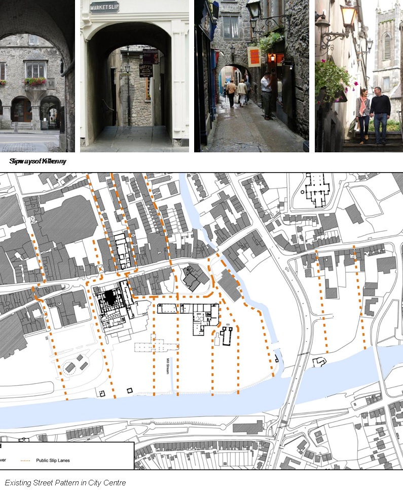
The City Centre ACA encompasses the medieval core of Kilkenny, the boundaries of which follow the line of the city wall to the west and north, the river to the east and Rose Inn Street to the south (see Figure 7.6). This area is defined by the central spine of the city running along High Street and Parliament Street with the medieval slips running to the east between High Street and Kieran Street and the surviving burgage plots to the rear of properties on High Street and Parliament Street. This part of the City contains some of the city’s most architecturally and historically significant structures including St. Francis Abbey, The Black Abbey, St. Mary’s Church, Rothe House, Shee Alms House, and the Hightown Circuit of the city walls, visual reminders of the city’s prosperity in the 14th, 15th and 16th centuries. The Tholsel and the Courthouse are also within this area representing major contributions from the 18th century.
Apart from these landmark buildings and structures (of which there is a high proportion in such a small area) the external built fabric of these streets dates to the 18th and 19th centuries. Even within this however, there are small reminders of the medieval past incorporated into many of the city’s structures, particularly on High Street, and it is highly likely that there is further medieval fabric hidden from view. The urban vernacular of much of the City Centre is characterised by rendered and painted facades with classically proportioned wall to window ratios and the survival of the timber sash as the most common window type.
One departure from this type is the east side of Parliament Street which is home to a number of redbrick four story over basement Georgian houses. Adjacent to these is an important reminder of the 19th century brewing industry in the St. Francis Abbey Brewery.
Character
The City Centre ACA is characterised by its evolution during the medieval period as Hightown, containing the residences of the merchant princes, the custom house/Tholsel, the market cross and later the courthouse. Much of the medieval street pattern survives with the main streets running along a north south central spine, having narrow slips unique to Kilkenny running downhill off the main street to the east and having long burgage plots running east to west to the rear of the properties on High Street and Parliament Street. The area today is characterised by a sizeable collection of landmark medieval and 18th century buildings set in an 18th and 19th century commercial streetscape of two and three storey rendered facades with classically proportioned wall to window ratios and many surviving early shop and pub fronts to ground floor. In the north east corner of the area is a significant element of Kilkenny’s 19th century industrial heritage in the form of the St. Francis Abbey brewing site.
The following Development Management Standards for the City Centre ACA are articulated as follows within Kilkenny City and Environs Development Plan 2014 - 2020.
CCACA 1: Assessment of proposals for the presentation of commercial premises will require retention of genuine early/original shopfronts/pubfronts, and the provision of high quality contemporary design when new shopfronts/commercial fronts are proposed,
CCACA 2: To maintain high standard of presentation of ground and upper floors by controlling the size, number and composition of advertisements on buildings to prevent and reduce visual clutter in the ACA. Plastic or neon signage will not be considered in the ACA.
CCACA 3: To protect the remaining surviving medieval street pattern and tight urban grain, particularly the burgage plots to the rear of High Street and Parliament Street limiting large scale developments which may necessitate assimilation of smaller historic building plots and retention of the existing scale of three and four storey buildings.
CCACA 4: To improve the visual appearance of the car parking area at the Market Yard and to ensure a high standard of architectural design for any development at Bateman Quay
St.Canices ACA
Description and historical background St. Canice’s Cathedral, which gives its name to the city (Cill Chainnigh, Church of Canice), is the central landmark in this area which encompasses an area running from Butt’s Green in the west to the river Nore in the east and bounded to the north by a line running from the Freshford Road west to Granges Road (See Figure 7.8).
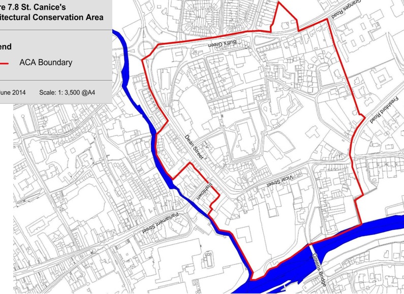
The area is known as Irishtown and was historically always separated from Hightown by the River Breagagh, prone to flash flooding at certain times of the year, forming a natural boundary between the two. The 13th Century St. Canice’s is still surrounded by the remnants of its close, including the 11th century round tower, the Bishop’s Palace, The Deanery, St. Canice’s library, almshouses and St. Canice’s steps. It is a complex of buildings of enormous significance architecturally, historically and culturally to the city. The area is characterised by narrow lanes and streets which surround the base of the mound on which the cathedral was built – Dean Street, St. Canice’s Place, Vicar Street and Troy’s Lane.
The area also includes sections of the medieval Kilkenny City Walls (Irishtown Circuit). The 13th century St. Francis Abbey is located in the south‐eastern corner of the Smithwick’s brewery site. This structure has survived substantially intact in spite of its location in the centre of a working brewery site but requires a strategy for future integration into any new developments which will be proposed on this site. St. Canice’s Catholic Church is another major landmark in the area, occupying a visually prominent position on another of the five hills of Kilkenny, terminating the vista westwards along Dean Street. It was built in 1824‐47 in the Gothic style by Rev. Jacob Gorman. The scale and the fine detailing throughout represent a quality rarely seen in churches predating Catholic Emancipation (1829), thereby indicating the religious tolerance in Kilkenny together with the relative prosperity of the local congregation.
The area is traversed by a number of small laneways enclosed by high stone walls. There is a predominantly residential character to the area with some institutional buildings and a small number of shops along Dean Street. The line of the Central Access Scheme runs through the area and a new bridge has been approved across the River Nore at the south eastern most section of the ACA. Green Street which runs east off Vicar Street towards Greens Bridge is an area of mixed uses with some vacant commercial buildings which have potential for renovation and re‐use.
Character
This is the area which gives its name to the city of Kilkenny. It is characterised by its separateness from the medieval Hightown , being located outside the walls and known as Irishtown, and is dominated by the Church of Ireland Cathedral, St. Canice’s, the current structure an impressive gothic structure dating to the 13th century. This church is surrounded by a complex of associated buildings of great architectural and historical importance to the city. Its attendant buildings are located on a hill, the streets and laneways that surround it and which criss‐cross it being another significant feature which contributes to the character of the area.
To the east of this complex is the area close to the river which includes that part of the19th century brewery site containing the remains of the 13th century St. Francis Abbey. To the west of the Protestant Cathedral is St. Canice’s Catholic Church, an 1820’s church in the gothic style with fine detailing, and a visually prominent landmark on the approach roads into the city. Surrounding these landmark buildings the area is predominantly residential in character with the exception of Dean Street., Green Street and the brewery site.
ACA Development Management Standards based on assessment of special character.
SCACA 1: To protect the historic and architectural character of St. Canice’s Cathedral and its unique setting and to protect the grouping of the Cathedral, Library, Deanery, and other buildings associated with the administration of the Cathedral.
SCACA 2: To protect and retain the historic integrity of the city walls, in accordance with the Kilkenny City Walls Conservation Plan.
SCACA 3: To encourage and facilitate the adaptation and re‐use of any derelict and under‐utilised buildings on Green Street.
SCACA 4: To ensure the buildings proposed following the completion of the Central Access Scheme proposal are designed in such a manner so as not to detract from the special character of the area and are sensitive to the existing scale of development within the area.
SCACA 5: To seek the conservation of St Francis Abbey and its setting.
SCACA 6: To ensure that any development occurring along the River Nore will be sensitive in its design and mindful of its proximity to the river.
Impact on Masterplan
 To maintain the existing scale within the city centre the Masterplan will be cogniscent of the variety and pattern of building heights and plot widths in the existing city centre.
To improve the visual appearance of the car parking area at the Market Yard the Masterplan will propose;
- the erection of new 3 to 4 storey buildings along the eastern edge of the car park to screen the view from the River Nore and create an improved streetscape along Bateman Quay
- the erection of new 3 to 4 storey buildings along the northern edge of the car park and ariund the Pump House to screen the view from the Courthouse and create an improved streetscape along Bateman Quay
To protect and retain the historic integrity of the city walls, the Masterplan will take into consideration the policies outlined in the Kilkenny City Walls Conservation Plan, published by the Heritage Council in 2005.
In addition the Masterplan will;
- propose the erection of 3 to 4 storey buildings along the Central Access Scheme to create an appropriate streetscape.
- propose to conserve St Francis Abbey and re-establish its original setting with respect to the City Walls, Evans Turret and the River Nore.
- propose the creation of a linear park along the River Nore while being cogniscent of the river as a Natura 20000 site, a Special Area of Conservation (SAC), and a Special Protection Area (SPA).
3.1.8 Site Analysis - Linear Park
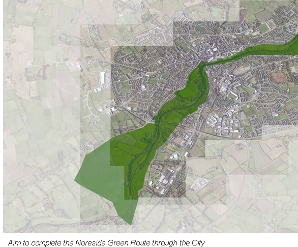
The Noreside walking trails include the Nore Valley Walk from the city centre to Bennetsbridge stretching south 11 kilometres, and the Bishops Meadows Walk to the north of the city stretching 2.6 kilometres. These walks are both on the western bank of the the River Nore. Currently there is a fracture in this trail as the St.Francis Abbey Brewery Site does not allow public access along the River Bank.
It is an objective of the Council to;
"Objective 6B - To complete the River Nore Linear Park within the lifetime of the Plan"
|
|
The Masterplan will propose the creation of a linear park along the River Nore to extend the existing walkways through the city centree while being cogniscent of the river as a Natura 20000 site, a Special Area of Conservation (SAC) and a Special Protection Area (SPA).
3.1.9 Site Analysis - River Bank Conditions
There are four river bank conditions existing within the masterplan site area. The first condition lies to the south of the Masterplan area adjacent to Bateman Quay. There is a grass bank along the Bateman Quay section of the river bank. This area varies in width from 3 metres at the southern end to 14 metres at the northern end where the Tea Houses are located. It is bordered by a 1.5m high wall or Bateman Quay (public road) to the west and 1.1m high steel railings on top of a stone wall to the east (river edge). This river edge treatment restricts access to the river itself. 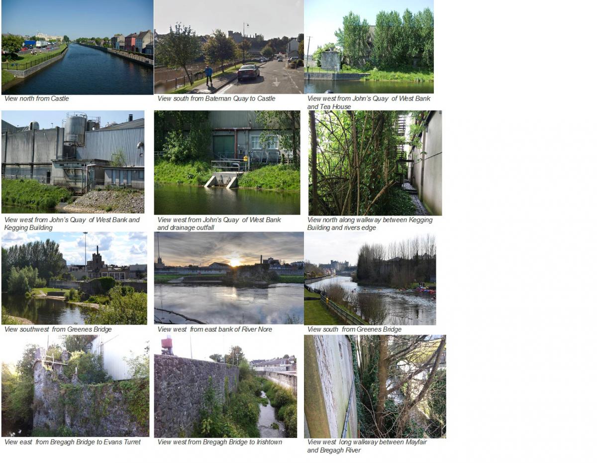
This environment makes it difficult to enjoy the river edge at this point, at one of the most beautiful parts of the River Nore with striking views south towards Kilkenny Castle. This poor environment combined with difficult access to the bank as a result of heavy traffic along Bateman Quay, results in very limited use by the public of this section of the river bank.
The second condition lies along the section of the river bank within the St.Francis Abbey site area. This area is typically 3 metres in width and is bordered by a tall warehouse structures to the west and a heavily overgrown river bank to the east planted with mature poplar trees. There are several areas at the river edge that are concreted over where drainage pipes discharge into the river.
This environment makes it difficult to enjoy the river edge at this point. There is no public access to this section of the river bank.
The third condition lies to the north of the confluence of the River Nore and Bregagh. There is a grass bank along this section approximately 20 metres wide. It is bordered by a 2.5m high wall to the west and a grass river bank to the east. This section of the river bank is used by several clubs, e.g. Kilkenny Aqua Canoe Club, to access the river.
The fourth condition exists along the River Bregagh where 1.5 metres high walls have been constructed on both the north and south banks of the river. The wall on the southern bank has been constructed on top of the old city wall.
River Access – Amenities
There is an active Kayaking and Canoeing club which operates from the river bank just south of Greens Bridge. An access slip is provided at this point but it is outdated and needs to be upgraded. Swimming is becoming more popular in the Nore between Greenes Bridge and Johns Bridge and this stretch has been used for the Nore Swim and various Triathlon events which take place in Kilkenny and the South East.
It is an objective of the Masterplan to improve access to the river through the masterplan area. The detail of this access will be considered in the preparation of the detailed design of the Linear Park and with consideration of the environmental requirements arising from the designation of the River Nore as a SAC and SPA.
3.1.10 Site Analysis - Tourism
Kilkenny City has much to offer as a tourist destination, in particular its rich natural, physical and cultural heritage and vibrant city life. In addition, there are annual festivals of national and international standards.
The Council are commited to;
- The development of sustainable tourism as an essential element in Kilkenny. This will be achieved through co-operation between Fáilte Ireland, Kilkenny Local Authorities, Kilkenny Tourism, Kilkenny Leader Partnership and neighbouring counties in the South East Region.
- The development of iconic attractions and other tourist attractions that will assist in the diversification of the tourism product, including varied projects such as the Medieval Mile, the River Nore Walking Route and Rothe House.
- The provision of adequate recreational and tourism infrastructure and to further develop tourist orientated facilities in the City and Environs.
- Promoting Kilkenny City and Environs as a designated conference centre in the Southeast Region.
- Facilitating the clustering of tourism products to increase linkages within and reduce leakage from, the local economy.
- Providing a need for a small, flexible venue to fulfil a multiplicity of roles ranging from space for community groups, dance, band rehearsal, theatre rehearsal, performance and storage facilities.
- Facilitating measures to encourage and promote activity based tourism in the city including walking, cycling and water‐based activities.
The following Policies of Kilkenny Borough Council, are articulated as follows within Kilkenny City and Environs Development Plan 2014 - 2020:
"Objective 6G - To develop an arts venue within the county to fulfil a multiplicity of artistic uses.
Objective 6H - To implement the Kilkenny Local Authorities’ Arts Strategy."
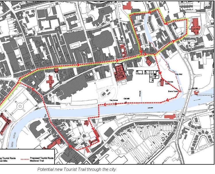
In response to the Council’s objectives with regard to the development of Kilkenny City as a tourist destination the Masterplan proposes to:
- Maintain quality of the urban fabric of the city by extending the medieval character of the streetscapes in the city centre into the site
- Maintain the historic buildings on the site and make them accessible to the public so adding a new tourist attraction
- Create new public spaces within the site
- Create a linear park along the River Nore and provide access to the river for various watersports.
3.1.11 Site Analysis - Flood Risk Analysis
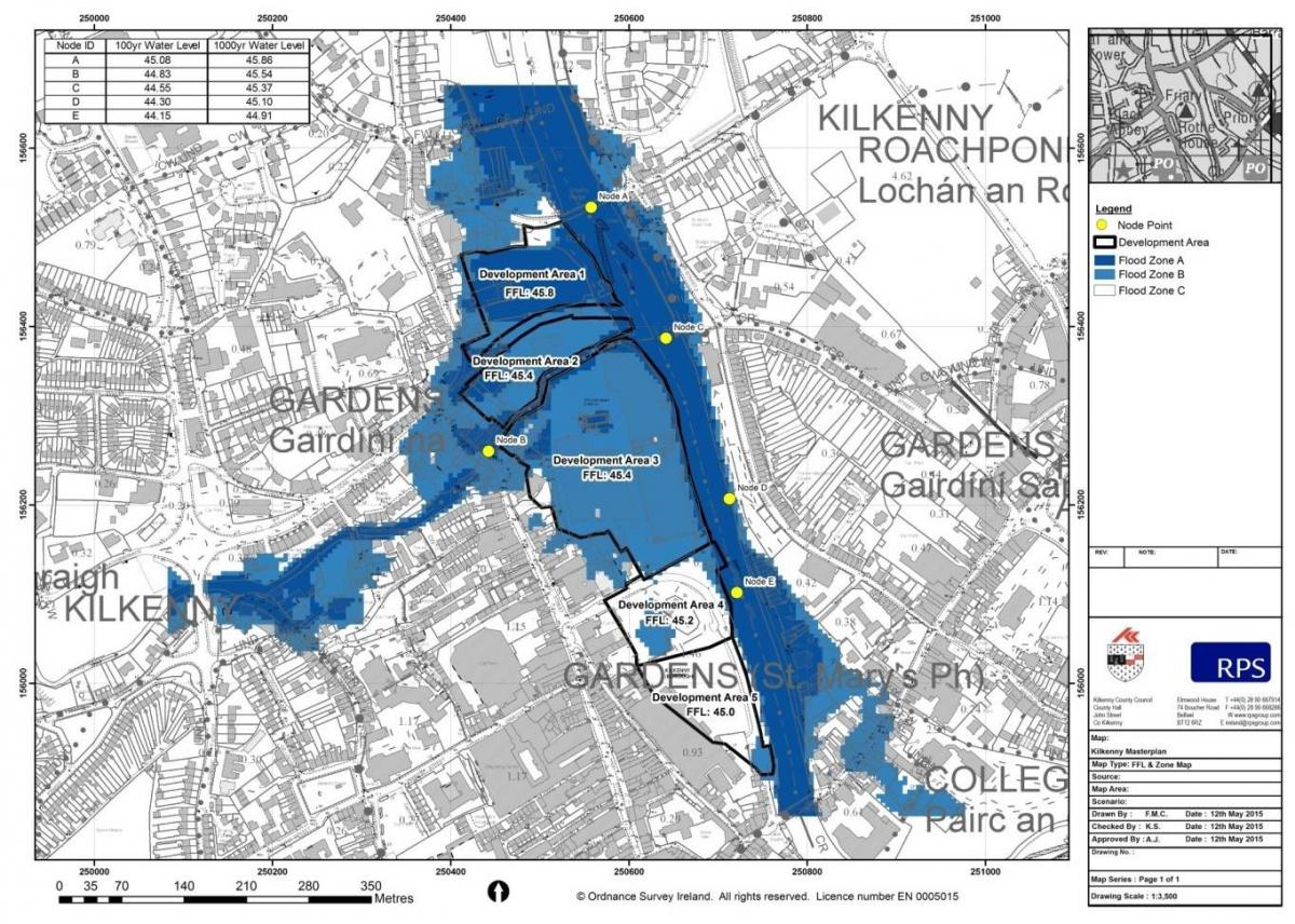
Historically the masterplan site had been subject to flooding primarily at the confluence of the River Bregagh and the River Nore. In response to a number of significant events in the late 1990s, the OPW completed the Kilkenny Flood Relief Scheme within Kilkenny City in 2005. The scheme incorporated river widening and deepening, improvements to the flood defences, dredging and construction or alteration to weirs and flood bunds and/or walls within the River Nore and its tributary, the River Breagagh. As a result of these works, the 100 year flood levels have been reduced across the masterplan site
Since 2012, The Office of Public Works’ national Catchment-based Flood Risk Assessment and Management (CFRAM) studies have analysed all areas considered to be at risk of flooding using the latest hydrological and hydraulic modelling techniques. The River Nore and the River Breagagh were included as part of the South Eastern CFRAM Study and detailed flood maps of both rivers have been produced. These indicate that the 1% Annual Exceedance Probability (AEP) flood level (1 in 100 year) varies between 45.08 m OD upstream of Green’s Bridge down to 44.15 m OD at the downstream extent of the proposed masterplan site. These flood levels compare favourably with existing ground levels in the vicinity of the Abbey and the brewery which vary from +44.67 to +44.85 m OD. The majority of the existing site is therefore above the 1% AEP level, and generally the remaining lower lying areas are protected by the existing flood defences. This represents a good standard of flood protection.
To support and inform the masterplan for the site, a detailed Flood Risk Assessment has been undertaken in accordance with ‘The Planning System and Flood Risk Management Guidelines for Planning Authorities’ (2009). This has assessed the flood risk in the context of the proposed development and has identified suitable mitigation measures to be incorporated into the Masterplan where appropriate, including setting finished floor levels for the development. The FRA has also demonstrated that the development does not result in increased flood risk elsewhere in the city. The intention is to provide protection from the 0.1% AEP (1 in 1000 year) event where possible to ensure the proposed development will be at a low risk of flooding.
Note: The Flood Zones illustrated assume that there are no defences in place. In reality, there are extensive defences in place which offer a good standard of flood protection.
|
Zone |
Existing Ground level |
Proposed Finished Floor Level |
|
1 |
44.2 – 44.5 m |
45.8m |
|
2 |
44.8m |
45.4m |
|
3 |
44.6m |
45.4m |
|
4 |
44.8 - 45.2m |
45.2m |
|
5 |
44.6 – 45.0m |
45.0m |
3.1.12 Site Analysis - Urban Scale
Kilkenny County Council will take possession of the St.Francis Abbey Brewery Site after Diageo have removed the majority of the industrial brewing structures on site. Accordingly the urban scale analysis relates to the urban scale of Kilkenny City as the proposed development will be required to reflect this medieval street pattern and scale.
Analysis of the existing streets within Kilkenny City centre identifies 4 main street types:
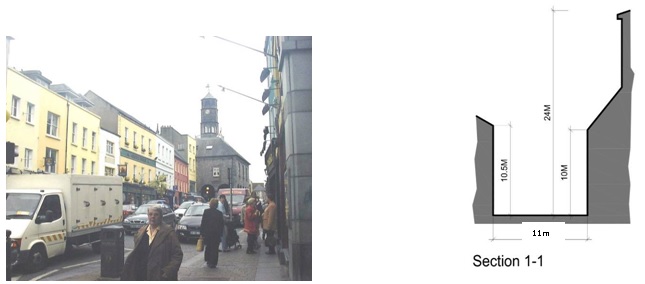
Type A includes High Street and Parliament Street, the principal streets running north south through the city and linking the Castle and St.Canices Cathedral, the two predominant buildings in the city. Streets are typically 11 metres wide enclosed with predominantly 4 storey buildings.
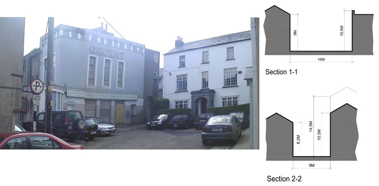
Type B includes William Street, Friary Street, and James Street secondary streets linking with High Street. Streets are typically 9 metres wide enclosed with predominantly 3 and 4 storey buildings.
Type C includes lanes such as New Building Lane and Evans Lane. Streets are typically 4 metres wide enclosed with predominantly 3 storey buildings.
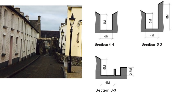
Type D includes lanes such as Butter Slip and Market Slip are typically 3.5 metres wide enclosed with predominantly 3 storey buildings.

Contents
Observations
Observations
Area Context
The view from Michael Street to St Francis Abbey should be included as a protected view.
3.1.2 Context of the Study Area, states that vehicular access is restricted primarily to the main entrance...
3.1 Masterplan Area Context.
The Central Access Scheme (CAS) is not included within this section despite the fact that its construction is well advanced. While the CAS does nothing to enhance the Abbey Creative Quarter,...
Objections To Brewery Site Masterplan
I object to a vote being taken at the end of July to put the master plan for the brewery site on a statutory basis before any proper archaeological survey. This is completely putting the cart before...
Area Context
The view from Michael Street to St Francis Abbey should be included as a protected view.
3.1.2 Context of the Study Area, states that vehicular access is restricted primarily to the main...