Section 2 The Proposed Amendment
2.1 Amendment Text and Map
Proposed Amendment No 2 of the Callan Local Area Plan (LAP) 2009-2020 consists of a written statement and an accompanying map.
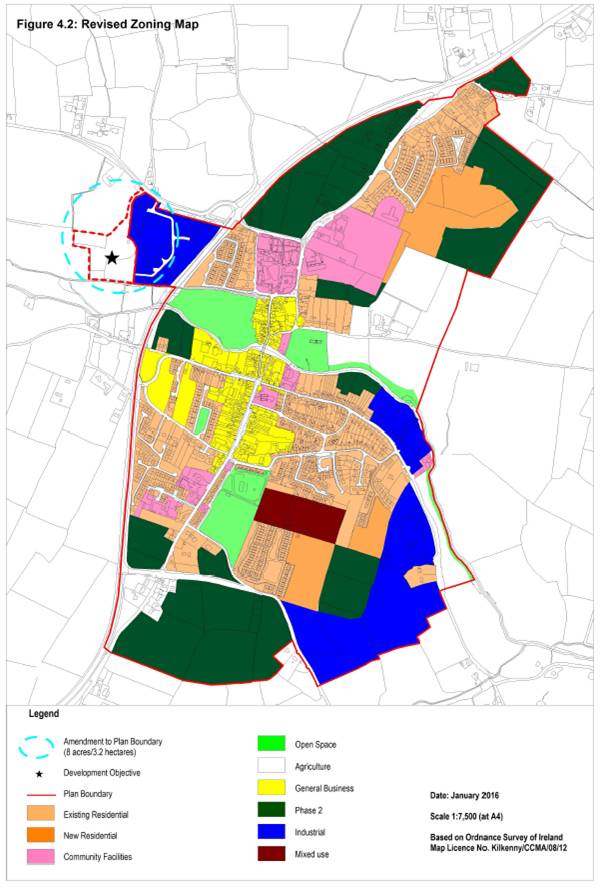
The Proposed Amendment involves the extension of the LAP boundary to include an 8 acre site at Westcourt, Callan as per Map 1. The land will be zoned ‘Agriculture’. The ‘Agriculture’ zoning objective to be included in the Plan is as follows:
Objective: To conserve and protect agricultural land from interference from non-agricultural uses. To prevent development of agricultural land adjacent to development areas which would prejudice the future expansion of the town, except in exceptional circumstances where there are site specific development objectives for the provision of certain types of development.
Permissible uses: Agriculture, horticulture, public service installations, uses identified in site specific development objectives.
Open for Consideration: Public open space, guesthouse, restaurant, nursing home, dwelling houses in certain limited cases, halting site, private open space, other uses not contrary to the proper planning and sustainable development of the area.
It is proposed to include a site specific objective for this land as follows:
To facilitate the development of a residential complex (10 units approx.) initiated by the Camphill Community with ancillary small scale socio-economic uses related to the activities of the residents of the development, and to provide for a pedestrian link from the lands to the town centre, subject to the following:
· The development must not interfere with the ecological integrity of the adjacent Kings River which forms part of the River Barrow and River Nore SAC, a Natura 2000 site. Any future development (including pedestrian link) of the lands will be subject to Appropriate Assessment in accordance with Article 6 of the Habitats Directive.
· A site-specific Flood Risk Assessment appropriate to the type and scale of the proposed development and a site specific justification test if required must be submitted at planning application stage in line with the DoEHLG Guidelines “The Planning System and Flood Risk Management”, November 2009. Residential use is excluded from Flood Zone B.
· Any developments proposed for the lands at Westcourt must be connected to the foul sewer network for treatment of waste water. Such developments will only proceed subject to the local treatment plant having capacity to adequately treat the additional load. It must be shown by proposals that all storm water can be appropriately collected, stored and treated so as not to affect the quality of water bodies.
· The archaeological importance of the site must be safeguarded by protecting archaeological sites and monuments (including their setting), and archaeological objects, including those that are listed in the Record of Monuments and Places, and in the Urban Archaeological Survey of County Kilkenny or newly discovered sub‐surface archaeological remains. Any proposed development in the vicinity or confines of archaeological monuments will require an archaeological assessment and the preparation of an archaeological impact statement for submission as part of any planning application for development within this area.
· When innovative layouts and exceptional design for living are achieved, strict adherence to the development management standards for new residential developments as set out in Chapter 12 of the County Development Plan 2014-2020 will not be required, provided the proposed designs can be demonstrated to satisfy the social and physical needs of the occupants.
2.2 Statutory Context
The Amendment has been prepared in accordance with Sections 20(3) of the Planning and Development Act 2000-2015.
LAPs are required to be consistent with the policies and objectives of the County Development Plan and its Core Strategy, as well as the Regional Planning Guidelines that apply to the area of the Plan.
The Amendment and the LAP should be read in conjunction with the Kilkenny County Development Plan 2014-2020, which sets out the overarching development strategy for the County.
2.3 Relationship with other relevant Plans and Programmes
2.3.1 Introduction
The Plan sits within a hierarchy of land use forward planning strategic actions. The Plan must comply with relevant higher level strategic actions and may, in turn, guide lower level strategic actions. The following sections identify a number of these strategic actions, further details of which are contained in the main Plan document.
The Plan is at the lower level of the hierarchy in the context of national, regional and county level plans. The preparation of the Local Area Plan has also been informed and influenced by various local government, national and international policy documents including (but not limited to) the following:
International
· Agenda 2000
· Local Agenda 21
· The European Spatial Development Perspective (ESDP)
· Various EU Directives
National
· Infrastructure and Capital Investment 2012-16: Medium Term Exchequer Framework, 2011
· Sustainable Development: A Strategy for Ireland, 1997
· National Spatial Strategy 2002 – 2020 (NSS)
· Ministerial Guidelines issued under Section 28 of the Planning and Development Act 2000-2011
Regional
· Regional Planning Guidelines for the South East Region 2010-2022
County
· Kilkenny County Development Plan 2014-2020
· Callan Local Area Plan 2009-2020. A SEA Environmental Report was prepared for the Callan Local Area Plan prior to its adoption in 2009. The life of the LAP was extended by a further 4 years (up to 2020) in 2014.
2.3.2 The National Spatial Strategy
The National Spatial Strategy 2002-2020 (NSS) is a planning framework for Ireland that aims to achieve a better balance of social, economic and physical development across Ireland, supported by effective planning. In order to drive development in the regions, the NSS proposes that areas of sufficient scale and critical mass will be built up through a network of gateways, hubs and key towns. The NSS is about people, places and potential, and the importance of making the most of our cities, towns and rural places to bring a better spread of opportunities, better quality of life and better places to live in.
It is anticipated that the NSS will be replaced by a National Framework Plan, in accordance with the Planning Policy Statement published by the Department of Environment in 2015.
2.3.3 Regional Planning Guidelines for the South East Region 2010-2022
The RPGs for the South East Region 2010-2022 provide the strategic regional mechanism for the implementation of the NSS. The Guidelines provide a planning framework for the future physical, economic and social development of the Region which includes County Kilkenny. A key aspect of the RPGs is integrating sustainable economic development with the protection and enhancement of the environment. The RPGs set out the vision for the Region through the formulation of strategic goals, policies and objectives which establish a framework for other lower level plans and programmes including development plans and local area plans.
It is anticipated that the RPG’s will be replaced with a Regional Spatial and Economic Strategy prepared by the Southern Assembly.
2.3.4 Kilkenny County Development Plan 2014-2020
The Kilkenny County Development Plan 2014-2020 sets out the strategic planning and sustainable development of County Kilkenny over its lifetime and is consistent with the National Spatial Strategy and the Regional Planning Guidelines.
Callan is identified as a key settlement in the County; a District Town. The population of Callan Town at the last census in 2011 was 2330 persons, which was an increase from 2006 when the population was 1771.
2.3.5 River Basin Management Plans
Local Authorities, including Kilkenny County Council, have prepared the Nore River Basin Management Plan which is implemented in order to help protect and improve waters in the town and wider River Basin District. The Plan and associated Programme of Measures includes provisions to help ensure that water bodies in the districts meet the objectives of the Water Framework Directive.
2.3.6 Catchment Flood Risk Assessment and Management Studies
Catchment Flood Risk Assessment and Management (CFRAM) Studies are being undertaken for the River Nore by the Office of Public Works.
The study is focusing on areas known to have experienced flooding in the past and areas that may be subject to flooding in the future either due to development pressures or climate change.
The final output from the study will be a CFRAM Plan. The Plan will define the current and future flood risk in the River Basin District and set out how this risk can be managed.
In November 2015, draft flood hazard and flood risk maps have been published by the OPW and are on public consultation at the time of writing.
2.3.7 Smarter Travel 2009
“Smarter Travel, A Sustainable Transport Future, A New Transport Policy for Ireland 2009 - 2020” is the Government’s action plan to free towns and cities from traffic congestion, substantially cut CO2 emissions, encourage car based commuters to leave their cars at home, and encourage a shift toward walking, cycling and greater public transport usage.
2.3.8 Food Harvest 2020
Food Harvest 2020 is a roadmap for the Irish food industry, as it seeks to innovate and expand in response to increased global demand for quality foods. It sets out a vision for the potential growth in agricultural output after the removal of milk quotas in 2015.
2.3.9 Environmental Protection Objectives
The Plan is subject to a number of high level environmental protection policies and objectives with which it must comply.
Examples of Environmental Protection Objectives include the aim of the EU Habitats Directive - which is to contribute towards ensuring biodiversity through the conservation of natural habitats and of wild fauna and flora in the European territory of Member States - and the purpose of the Water Framework Directive - which is to establish a framework for the protection of inland surface waters, transitional waters, coastal waters and groundwater which, among other things, prevents deterioration in the status of all water bodies and protects, enhances and restores all waters with the aim of achieving good status by 2015.