Second Schedule 30km/h
PART A
Roads in respect of which a special speed limit of 30 km/hr is prescribed. The special speed limit only applies during those periods when the special speed limit sign is illuminated and specifies the limit as 30 km/hr. During all other periods the default or special speed limit for that location applies.
1. The following roads in Kilkenny Municipal District City and Environs
(a) The Callan Road (N76) adjacent to the entrance to Seville Lodge from a point 50m north of its junction with the LS6695 for a length of 447m northwards.
(b) Cuffesgrange Village (LS 5041) adjacent to the entrance of Cuffesgrange National School from a point 247 metres from its junction with the Callan Road (N76) for a length of 385 metres westwards.
(c) The Kells Road (R697) adjacent to the entrance to St. Patrick’s Special
School from a point 334m from its junction with the Ring Road (N76) for a length of 390m southwards.
(d) The Outrath Road (LP2611) adjacent to Gael Scoil from a point 21m from its junction with the Bohernatounish Road (LP2610) for a length of 338m southwards.
(e) The Springfield Road adjacent to the entrance to Kilkenny School Project from a point 22m from its junction with the Waterford Road (R910) for a length of 60m westwards.
(f) The Freshford Road (R693) adjacent to St. Canice’s Primary School from a point 50m south of its junction with Greenfields Court for a distance of 250m southwards.
(g) The Granges Road (Road Schedule No. 2) from a point 279m
south of it’s intersection with the Dunningstown Road to a point
96m north of it’s junction with Lord Edward Street (Road Schedule No.3).
(h) Ballybought Street (Road Schedule No.45) adjacent to Ballybought Street National School from a point 29m from it’s junction with Castlecomer Road (N77) for a length 287m eastwards.
2. The following roads at Ballyfoyle
On the LP1841, for a distance of 50m South of its junction with LP 1844 at Hand Ball Alley to a point 280m South of its junction with the LP 1844 to Damerstown.
3. The following roads at Ballyhale
On the N9(R448) from a point 350m south of its junction with the Coolmore Rd (LS8256) to a point 60 metres south of said junction.
4. The following roads at Ballyragget
On the N77, for a distance of 205m South of its junction with the LS5911 at Castle Gardens to a point 160m North of its junction with the LS5911.
5. The following roads at Bennettsbridge
On the LP2635 from a point 30m west of its junction with Marian Place to a point 39m east of its junction with the LP2632.
6. The following roads at Burnchurch
The LS 5042 from a point 27 metres south east of its north eastern junction with the LP1016 to point 212 metres south east of said junction.
7. The following roads at Callan
West Street (R699) from a point 40 metres west of its junction with Mill Street (R699)/Green Street/Upper Bridge Street to a point 280 metres west of said junction.
8. The following roads at Castlecomer
(a) On the LS5853 Old Ballyragget Road, for a distance of 20m West of its western junction with the Glebe, Marymount Housing Estate, LS 5897 to a point 160m from its eastern junction with the LS 5897.
(b) High Street on the N.78, for a distance of 145m East of its junction with the R.426 to a point 235 East of its junction with the R.426.
9. The following roads at Clara
On the LP2628 from a point 438m west of its junction with the LS6657 to a point 753m west of said junction.
10. The following roads at Clinstown, Jenkinstown
On the N77, for a distance of 350m South East of its junction with the LS5863 to a point 610m South East of its junction with the LS5863.
11. The following roads at Clogh
On the LP1830, for a distance of 65m Northy West of its junction with the LS5868 to a point 420m South East of its junction with the LS5868.
12. The following roads adjacent to the town of Dunamaggin
The Raheen Road (LS 5070) from a point 40 metres north east of its junction with the Callan to Knocktopher Road (R699) to a point 109 metres north east of said point.
13. The following roads at Goresbridge
On the LS2641 from a point 24m north east of its junction with the Gowran to Goresbridge Rd (R703) to a point 40m south west of its junction with the LP2639
And
On the R703 from a point 56 metres east of its junction with the LS2541 to a point 281 metres east of said junction.
14. The following roads at Gowran
On the LP2637 from a point 215m west of its junction with the Carlow to Waterford Rd
(N9(R448)) to a point 110m south of its junction with the Kilkenny Road (R702).
15. The following roads at Graiguenamanagh
(a) On the LS8224 from a point 10m east of its junction with the LS8222 at Fair Green to its junction with Brays Lane LS8225.
(b) On the R705 (High St) from its junction with Turf Market to a point 20m north west of tis junction with Old High St.
16. The following roads at Johnstown
On the N8, for a distance of 347m South East of its junction with the R435 to a point 527m South East of its junction with the R435.
17. The following roads at Kilmacow
Kilmacow to Dangan Rd (LP3403) from a the junction with Dangan to Clogga Rd
(LP3402) to a point 441m south of this junction
18. The following roads at Kilmanagh
(a) The Kilkenny to Callan Road (R695) from a distance of 138 metres south of its junction with the Tullaroan Road (LP1009) to a point 51 metres east of said junction.
(b) The Tullaroan Road (LP1009) for a distance of 141 metres west of its junction with the Kilkenny to Callan Road (R695).
19. The following roads at Moneenroe
On the LP1832, for a distance of 70m North East of its junction with the LS5872 On the LS5872, from its junction with the LP1832 to a point 135m South West of its junction with the LS5872 to a point 305m South East of its junction with the LP1832.
20. The following roads at Mooncoin
(a) Waterford to Carrick on Suir Rd (N24) from a point 46m east of the Junction of Pollrone Rd (LS7417) to a point 464m east of this said junction.
(a) Waterford to Carrick on Suir Rd (N24) from a point 49m West of the junction with local road (LS7442) to a point 27m west of the junction of the Ballytarsney Rd (LS4919)
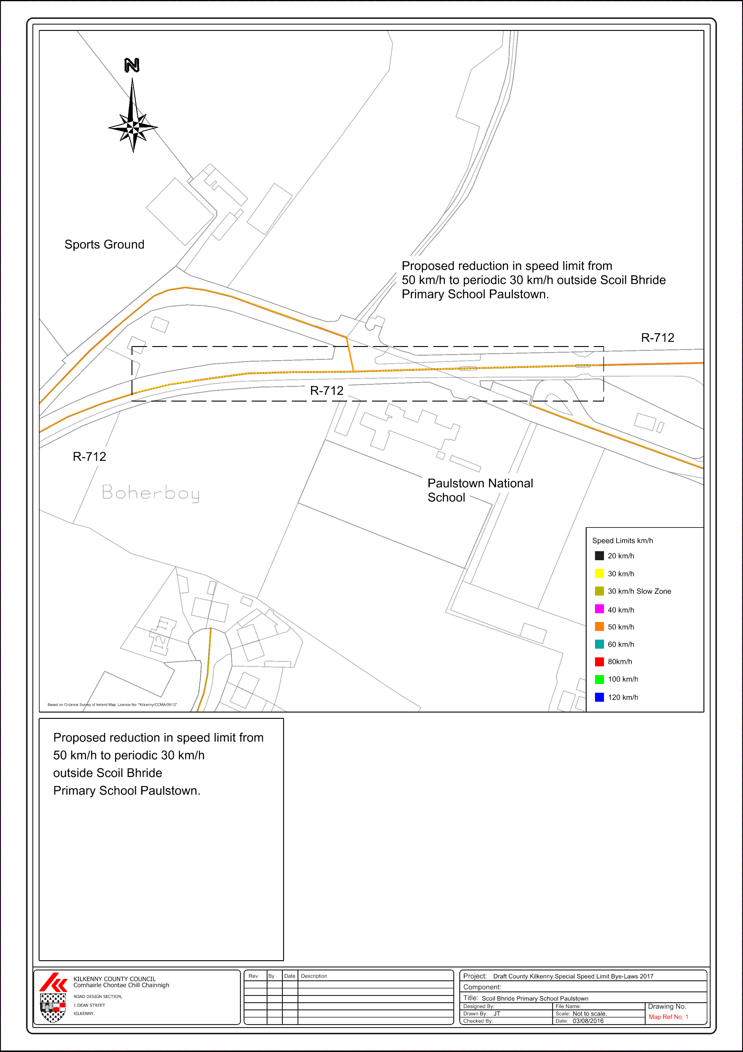
21. The following roads at Paulstown Map Ref No 1
Paulstown to Kilkenny Road (R712) from a point 67m West of the Junction of Paulstown to Gowran Road (R448) to a point 125m West of the junction with Local Road (LT 66821)
22. The following roads at Piltown
Piltown to Callan Rd (R698) from a point 20m north of the New Road (LS5125) to a Point on the Piltown to Callan Rd (R698) 427m South of this junction
23. The following roads at The Rower
On the Graiguenamanagh to New Ross road (R705) from a point 75m south west of its junction with the Old New Ross Rd (LP4218) to a point 25m north of the its junction with the Knockatore Road (L4217).
24. The following roads at Slieverue
On the Old Waterford to New Ross Rd (LP3411) from a point 80m from the junction of the new Waterford to New Ross Rd (N25) to a point on the old Waterford to New Ross (LP3411) 320m from the said junction.
25. The following roads at Thomastown
On Ladys Well St from a point 232m north of its junction with Pipe St to its junction with LP4207 / LS 8202.
26. The following roads at Urlingford
On the LP1812, for a distance of 125m North West of its junction with Lumper Lane, LT18121 to a point 343m North West of its junction with Lumper Lane, LT18121.
SECOND SCHEDULE – 30km/h
PART B
Roads in respect of which a special speed limit of 30 km/hr is prescribed. The special speed limit only applies during those time periods specified on the sign. During all other periods the default speed limit for that location applies.
1. The following roads at Ballyfassy
On the Mullinavat to Kilbride Rd (LP3426) from a point 435m from the Thomastown Rd (LP3419) to a point 678m from the said junction (LP3426/ PL3419)
2. The following roads at Ballyragget
On the R694, for a distance of 72m North East of its junction with the LS5916 to a point 242m North East of its junction with the LS5916.
3. The following roads at Bigwood
On the Gaulsmills to Ballyhomuck Rd (LS7460) from a point 116m north west of the junction with the local Rd (LS7457) to a point 67m south of the junction with the Cats rock Rd (LS7458) and the Gaulsmills Rd (LS7458)
4. The following roads at Carrigeen
On the Corluddy Rd (LS7439) from a point 337m south of the junction with the local road to Ballygorey (LS7436) to a point 516m south of the said junction.
On the Licketstown Rd from the junction at the Church for a distance of 146 from the junction.
5. The following roads at Castlecomer
(a) On the LS5898, from its junction with the LS5900 to a point 135m North of its junction with the LS5900.
(b) On the N78, from a point 100m North of its junction with the LS5898 to a point 230m North of its junction with the LS5898.
6. The following roads at Clontubrid
On the LP1810 from its junction with the LP1808. On the LP1808, for a distance of 210m North West of its junction with the LP1810. On the LP1809, for a distance of 90m South East of its junction with the LP1810 to a point 204m South West of its junction with the LP1808 to its junction with the LP1810 to its junction with the LP1810.
7. The following roads at Coan
On the LS5879, for a distance of 110m North West of its junction with the LP1838 to a point 392m North of its junction with the LP1838.
8. The following roads at Crosspatrick
On the LP1800, for a distance of 85m East of its junction with the LS5811 to a point 358m East of its junction with the LS5811.
9. The following roads at Danesfort
The Danesfort to Ballymack road (LP4200) from a point 59 metres west of its junction with the Kilkenny to Waterford Road (N10) to a point 420 metres west of said junction.
10. The following roads at Firoda, Castlecomer
On the LP1829 for a distance of 465m North West of its junction with the LS5850 to a point 600m North West of its junction with the LS5850.
11. The following roads at Freshford
On theMoat Road, LS5005, for a distance of 15m East of is junction with the LP1002 to a point 145m East of its junction with the LP1002.
12. The following roads at Galmoy
On the LP1801, for a distance of 765m North East of its junction with the R435 to a point 1045m North East of its junction with the R435.
13. The following roads at Gathabawn
On the LP1803, from a point 62m West of its junction with the LS5618 and LP1804 to a point 313m West of its junction with the LS5618 and LP1804.
14. The following roads at Glenmore
Main St Glenmore (LS7510) from a point 267m South west of the Mullinavat Road (LP3428) to a point 553 South West of the said junction.
15. The following roads at Graiguenamanagh
On the LS8221 from a point 87m north west of its junction with Barrow Lane to a point 348m north west of the said junction.
16. The following roads at Inistioge
On the R700 from a point 153m north of its junction with the Killeen Rd (LP4216) to a point 343m north of the said junction.
17. The following roads at Jenkinstown
On the LS5859, for a distance of 200m North of its junction with the LS5861. On the LS5861, from its junction with the LS5859 to a point 200m South West of its junction with the LS5861 to a point 180m South of its junction with the LS5859.
18. The following roads at Johnstown
On the R435, for a distance of 128m North West of its junction with the R502 to a point 353m North West of its junction with the R502.
19. The following roads at Johnswell
On the LS6655 from a point 50m north of its junction with the LS6734 to a point 85m south of its junction with the LS6654.
20. The following roads at Kells
The Kells to Stoneyford road (LP 1027) from a point 33 metres south east of its junction with the Kells to Kilkenny Road (R697) & LP1026 to a point 250 metres south east of said junction.
21. The following roads at Kilmacow
On the Dangan Rd (LP3403) from a point 73m north of the junction with the Narabane Rd (LP3401) to a point 355m north of the said junction.
22. The following roads at Kilmaganny
(a) The Kilmaganny to Knocktopher Road, R701 from a point 39 metres west of
its junction with the LS 5091 to a point 180 metres north east of said junction.
(b) The LS 5091 for a distance of 20 metres east of its junction with the
Kilmaganny to Knoctopher Road (R701).
23. The following roads at Lisdowney
On the LP1807, for a distance of 30m East of its junction with the LP1811 to a point 390m East of its junction with the LP1811.
24. The following roads at Lisnafunchion
On the LP1823, for a distance of 155m North East of its junction with the LS5860 On the LS5860, from its junction with the LP1823 to a point 170m South West of its junction with the LS5860 to a point 140m North West from its junction with the LP1823.
25. The following roads at Listerlin
The Listerlin to Ballyneale Rd LS7491 from a point 16m from the junction with Thomastown Rd LP3421 in an easterly direction to a point 231m from the said junction.
26. The following roads at Mullinavat
(a) On the Mullinavat to Hugginstown Rd (LP1037 from a point 48m north of the junction with the Piltown Rd (LP1042) to a point 130m north of the said junction.
(b) On the Hugginstown Rd (LP1037) from a point 48m north of the Clonassy Rd (LP1042) to a point 130m north of the said junction.
27. The following roads at Newmarket
The LP 4212 for a distance of 31 metres south east of its junction with the LP4211 to a point 190 metres south east of said junction.
28. The following roads at Owning
On the Piltown to Callan Rd (R698) from appoint 20m north of the junction with the White Church Rd (LS5108) to a point 190m north of the said junction.
29. The following roads at Ringville
On the local road (LS7470) from a point 25m from the junction with the Rochestown to Drumdowney Rd (LS7471/ LP3415) to a point 212m from the said junction
30. The following roads at Skeoghvosteen
On the LS6729 from a point 125m west of its junction with the LS8217 to a point 15m south west of its junction with the LS8218.
31. The following roads at Strangsmill (Dunkitt)
On the Mullinabro to Dunkitt Rd (LP3405) from a point 38m west of the local road (LT34056) to a point 528m west of the said junction.
32. The following roads at Templeorum
On the Piltown to Callan Rd (LP1035) from a point 16m south of the junction with the local road (LS5113) to a point 250m from the said junction
33. The following roads at Tullaroan
The LP1008 from a point 114 metres north of its junction with the Tullaroan to Kilkenny Road (LP1007) to a point 378 metres north of said junction.
34. The following roads at Windgap
(a) The LP1033 from a point 28 metres west of its junction with the Callan to Windgap Road (R698) to a point 187metres west of said junction.
35. The following roads at Boherboy and Paulstown
(a) R712 from a point 70m west of its junction with the R448 to a point 330m west of the said junction.
(b) R448 from its junction with the R712 to a point 110m south of said junction.
SECOND SCHEDULE - 30km/h
PART C
Roads in respect of which a special speed limit of 30 km/hr is prescribed.
1 The following roads in the Kilkenny Municipal District City
All roads in the area enclosed by a line commencing at a point on the Kennyswell Road (R695)180m east of its junction with the Circular Road (L6950) and drawn thence in straight lines successively to the following points.
(a) A point on Lord Edwards Street (LP1007) 210m west of its junction with the Granges Road(LP2600)/ Butts Green(LP2600) Junction.
(b) A point on the Granges Road(LP2600)/ 50m north of its junction with Lord Edwards St(LP1007) / Butts Green(LP2600) Junction.
(c) A point on the Freshford Road (R693) 660m south west of its junction with the Granges Road(LP2600).
(d) A point on Greenshill (LP2665)60m north of its junction with Greensbridge (R886).
(e) A point on New Road (R886)45m east of its junction with Greensbridge(R886).
(f) A point on the Castlecomer Road(R712) 50m north of its junction with Ballybought St(L2613)
(g) A point on Ballybought (L2613). Street 240m north east of its junction with the Castlecomer Road (R712).
(h) A point on the Hebron Road(LP2627) 310m north east of its junction with the Caslecomer Road (R712).
(i) A point on the Dublin Road(R712) 320m south east of its junction with John Street upper(R887).
(j) A point on the Castle Road(R700) 560m south east of its junction with Rose Inn Street(R887).
(k) A point on the Waterford Road (R916) 140m north west of its junction with the Nuncio Road (LP2667).
(l) A point on the Kells Road(R697) 270m south west of its junction with Upper Patrick Street(R910).
(m) A point on the College Road(R909) 45m south west of it junction with New Street(LP2666).
(n) A point on the Old Callan Road (R950)25m north of it junction with the College Road (R909).
(o) A point on the Circular Road(L6950) 35m north west of its junction with the College Road (R909).
(p) A point at White Bridge (Wetlands) 20m south west of its junction with the Circular Road (R909).
(q) A point on the Circular Road (L6950) 560m south of its junction with the Kennyswell Road (L695).
and from the last mentioned point in a straight line to the commencement point on the Kennyswell Road(R695).
SECOND SCHEDULE - 30km/h
PART D
Roads in respect of which a special speed limit of 30km/h on listed housing estates and local residential roads is prescribed.
1. The following housing estates and all roads within those housing estates in the Municipal Area of Castlecomber.
[map ref no 2]
(a) Ballyragget
i. Castle Gardens
ii. Riverside View
iii. Station Road
iv. High Street
v. Greenview
vi. Grove Terrace
vii. Brookfield
viii. Fari Green
(b) Castlecomer
i. Marymount
ii. Donaguile Heights
iii. Hillsode View
iv. Donaguile
v. Church Avenue
vi. Maryville
vii. Kilkenny Road
viii. Ballyhemmin Upper
ix. Love Lane
(c) Clogh
i. Cois Na Abhain
ii. Chatsworth
(d) Coon
i. Castle Hill
(e) Freshford
i. Woodview
ii. Ard Lachtain
iii. Nuenna Court
(f) Goresbridge
i. Barrowmount Drive
ii. Cluain Mhuire
(g) Gowran
i. Parkmore Terrace
ii. Rockfield
(h) Johnstown
i. Canal Road
ii. Foulkscourt
iii. St Kiernan Place
(i) Kilmanagh
i. Council Estate
(j) Moneenroe
i. Massford
ii. Salome Place
iii. Fr Raftice Place
iv. Houses for the Elderly
(k) Urlingford
i. Emerald Gardens
ii. Mount Finn
iii. St Marys Avenue
iv. Assumption Place
v. Chapel Fields
vi. Riverside Park
vii. Togher Lawns
viii. Togher Ways
ix. Togher Cresent
2. The following housing estates and all roads within those housing estates in the Municipal Area of Kilkenny.
(a) Ballyhale
i. Vicars Lane
ii. Brookhaven
(b) Bennettsbridge
i. Norewood Heights Upper
ii. Hill View
iii. The Ring
iv. Woodlawn
v. Norewood Heights (Lower)
(c) Callan
i. Abhainn Ri
ii. Prologue
iii. The Meadows
iv. Edmund Rice
v. Collins Park
vi. Bolton/Cluid
vii. Bolton
(d) Dunamaggin
i. St Leonards Court
(e) Graiguenamanagh
i. Fairview
ii. Newpark
iii. Brandon Park
iv. Cottage Gardens
(f) Inistioge
i. Mill Road
(g) Kells
i. Mill Lane
ii. Priory Grove
iii. Burgess Court
(h) Kilkenny City and Environs
i. The Sycamores
ii. Clarinwood
iii. Park View Drive
iv. Connolly Street
v. St Josephs Road
vi. Pearse Street
vii. Thomases Square
viii. Emmet Street
ix. Kilcreene Cottages
x. Rushbrooke
xi. Drakelands Estate
xii. De Loughry Place
xiii. Fr Murphy Square / Francis Terrace
xiv. Walkin Stree Estate
xv. Old Callan Road Estate
xvi. College Gardens
xvii. Dean Kavanagh Estate
xviii. McCauley Place
xix. College Court
xx. College Gardens
xxi. Shellumsrath Estate
xxii. Ashurst Estate
xxiii. Asleigh Court
xxiv. Corcoran Terrace
xxv. Maiden Hill
xxvi. Mayfield
xxvii. Bregagh Place
xxviii. Kells Rd Estate
xxix. Springfirlds
xxx. Clongowan
xxxi. Cashel Downes
xxxii. Evendale Close
xxxiii. Larchfield
xxxiv. Garden Villas
xxxv. Kinealy Avenue
xxxvi. Old Bennetsbridge Road
xxxvii. Beech Park
xxxviii. Canal Walk
xxxix. Dukesmeadows
xl. Woodbine Avenue
xli. Melville Heights
xlii. Laurel Drive
xliii. Outrath Court
xliv. Cedarwood Drive
xlv. Archers Cresent
xlvi. Springmount
xlvii. Smithsland Court
xlviii. West Field
xlix. Sion Meadows
l. Leggetsrath Cottages
li. Shandon Park
lii. Lacken Drive
liii. Assumption Place
liv. O Loughlin Road
lv. Bishop Birch Place
lvi. St Marys Avenue
lvii. St Marys Cresent
lviii. Hebron Road
lix. Poococke Lower
lx. Rosewood
lxi. Garren Green
lxii. New Orchard Estate
lxiii. The Fairways
lxiv. The Orchard
lxv. Ashfield
lxvi. New Park Lower
lxvii. New Park Close
lxviii. Meadow Way
lxix. Newpark Lawn
lxx. Kilsheelan Heights
lxxi. St Mauls
lxxii. Richview
lxxiii. The Weir
lxxiv. Glendine Heights
lxxv. Glendine Woods
lxxvi. Brougue Markers Hill
lxxvii. Bridge View Gardens
lxxviii. De La Salle Place
lxxix. Parkview Drive
lxxx. Loreto Park
lxxxi. Greenfields
lxxxii. Whitegate Lawn
lxxxiii. St Patricks Close
lxxxiv. St Fiacras Place
lxxxv. Kilfera
lxxxvi. Kilfera Court
lxxxvii. Danville
lxxxviii. Dunmore Church
lxxxix. Dunmore East
xc. Margaret’s Field
xci. Burnell Walk
xcii. Estate at New Orchard Roundabout
xciii. The Grange
xciv. The Green Airfield.
(i) Knocktopher
i. Estate Off R699 (M9 Side)
ii. Whitecastle
(j) Stoneyford
i. Lawcus Fields
ii. Chapel View Estate
iii. Community Centre Road
(k) Thomastown
i. Maudlin Court
ii. Newtown Tee
iii. Cloghabrody Heights
iv. Castle Ave
v. Dangan Terrace
vi. Norewood Heights Lower
vii. Mallfield
viii. Hillview
3. The following housing estates and all roads within those housing estates in the Municipal Area of Piltown.
(a) Aglish
i. Aglish
(b) Ferrybank
i. Clover Meadows
ii. The Cresent, Belmount
iii. Castle Oaks
iv. Ashbrook
v. Hollybrook
vi. Blackthorn Hills
vii. The Beeches
viii. Silverwood
ix. Mullinabro Woods
x. Abbey Park
xi. Estuary Woods.
(c) Fiddown
i. Coirceog
ii. Kylemore
iii. The Fairgreen
(d) Glenmore
i. The Sallies.
(e) Kilmacow
i. Shamrock Grove
ii. Dangan 1
iii. Dangan 2
(f) Mooncoin
i. Cul-de-sac near Suir Cresent
ii. Suir Cresent
iii. Polerone Green
iv. St Annes Terrace
v. Comeragh View
vi. Mooncoin Heights
(g) Mullinavat
i. Fr Maher Place
(h) New Ross Environs
i. Millbanks Grove
ii. Beech Grove
iii. O Sheas Green
(i) Piltown
i. Beline Vale
ii. The Meadows
iii. Hillcrest Avenue
iv. Kildalton Close
v. Orchard Estate
vi. Beline
vii. Power Villas
(j) Slieverue
i. Ashgrove
ii. The Orchard