Appendix B - Strategic Environmental Assessment (SEA) Non Technical Summary
SEA Non Technical Summary (Download SEA Non Technical Summary)
Table of Contents
Section 1 Introduction and Terms of Reference ..................................................... 1
Section 2 The Draft Masterplan .............................................................................. 2
2.1 Introduction ..................................................................................................................... 2
2.2 Content and Layout .......................................................................................................... 2
2.3 High level Objectives ........................................................................................................ 2
2.4 Relationship with other relevant Plans and Programmes ...................................................... 3
Section 3 The Environmental Baseline ................................................................... 4
3.1 Introduction ..................................................................................................................... 4
3.2 Likely Evolution of the Environment in the Absence of the Masterplan ................................... 4
3.3 Biodiversity and Flora and Fauna ....................................................................................... 5
3.4 Population and Human Health ........................................................................................... 5
3.5 Soil ................................................................................................................................. 6
3.6 Water .............................................................................................................................. 6
3.7 Air and Climatic Factors .................................................................................................... 7
3.8 Material Assets ................................................................................................................. 7
3.9 Cultural Heritage .............................................................................................................. 8
3.10 Landscape ....................................................................................................................... 9
3.11 Appropriate Assessment and Flood Risk Assessment .......................................................... 13
3.12 Strategic Environmental Objectives .................................................................................. 13
Section 4 Alternatives ........................................................................................... 14
4.1 Introduction ................................................................................................................... 14
4.2 Description of Alternatives .............................................................................................. 14
4.3 Evaluation of Alternatives ................................................................................................ 15
Section 5 Assessment of Draft Masterplan Provisions ......................................... 20
5.1 Overall Findings ............................................................................................................. 20
5.2 Potential Adverse Effects and Residual Effects .................................................................. 20
Section 6 Mitigation and Monitoring Measures .................................................... 21
6.1 Mitigation ...................................................................................................................... 21
6.2 Monitoring ..................................................................................................................... 21
Section 1 Introduction and Terms of Reference
This is the Non-Technical Summary of the Environmental Report for the Draft Masterplan for Abbey Creative Quarter 2015. The purpose of the Environmental Report is to provide a clear understanding of the likely environmental consequences of decisions regarding the adoption and implementation of the Masterplan.
What is an SEA?
SEA is a systematic process of predicting and evaluating the likely environmental effects of implementing a proposed plan, or other strategic action, in order to ensure that these effects are appropriately addressed at the earliest appropriate stage of decision-making on a par with economic, social and other considerations.
Why is it needed?
The SEA is being carried out in order to comply with the provisions of the SEA Directive and in order to facilitate contributions towards environmental protection and sustainable development. The output of the process is an Environmental Report which should be read in conjunction with the Draft Masterplan.
How does it work?
All of the main environmental issues in the area were assembled and presented to the team who prepared the Draft Masterplan. This helped them to devise a Masterplan that protects whatever is sensitive in the environment. It also helped to identify wherever potential conflicts between the Draft Masterplan and the environment exist and enabled these conflicts to be mitigated. The SEA was
scoped in consultation with designated environmental authorities with submissions received influencing the scope of the assessment.
What is included in the Environmental Report which accompanies the Draft Plan?
The Environmental Report contains the following information:
o A description of the environment and the key environmental issues;
o A description and assessment of alternatives for the Draft Masterplan;
o An assessment of the provisions of the Draft Masterplan; and,
o Mitigation measures which set out to aid compliance with important environmental protection legislation - e.g. the Water Framework Directive, the Habitats Directive - and which will avoid/reduce the environmental effects of implementing the Masterplan.
What happens at the end of the process?
An SEA Statement will be prepared which will summarise, inter alia, how environmental considerations have been integrated into the Masterplan.
Section 2 The Draft Masterplan
2.1 Introduction
It is an objective in the Kilkenny City and Environs Development Plan 2014-2020 (Objective 3C) to prepare a Masterplan and Urban Design Framework for the Smithwick’s site and Bateman Quay area in Kilkenny City. Kilkenny County Council has prepared the Masterplan and Urban Design Framework in compliance with this objective.
The Masterplan document is a non-statutory document. It is intended to place the document on a statutory footing by way of Variation No. 1 to the City Development Plan (this Proposed Variation and associated SEA and AA documents have been placed on public display at the same time as the Masterplan and its associated SEA and AA documents).
The City Development Plan currently zones the Masterplan area as ‘General Business’ with Recreation, Amenity and Open Space’ zoning provided along the river.
2.2 Content and Layout
The Masterplan is laid out in six sections as follows:
1. Introduction
2. Context
3. Analysis
4. Masterplan Strategies
5. Masterplan Proposals
6. Appendices
2.3 High level Objectives
Arising from an analysis of the issues identified in the Kilkenny City and Environs Development 2014 - 2020 Plan the following objectives were developed for the Masterplan:
To advance the co-operation between Kilkenny Local Authorities, existing third level institutions and the proposed Technology University for the South East.
To support employment creation, innovation and lifelong learning.
To promote the sustainable development of the city
To provide the highest quality living environments possible
To guide the location and pattern of development whilst ensuring a relatively compact urban form is maintained
To promote balanced and sustainable economic development and employment by ensuring that a diverse range of economic sectors are developed
To develop an integrated transport strategy for the city linked to land use objectives, which facilitates access to a range of transport modes
To protect, conserve and enhance the built and natural heritage of the city
To promote the regeneration of the city centre and to protect and promote the city centre as the commercial and cultural focus for the city
To advance the redevelopment of the Bateman Quay site for civic and prime retail use
To provide a hierarchy of parks, open spaces and outdoor recreation areas and to use the river corridors of the River Nore, Breagagh and Pococke to provide open space for the city while having due consideration to their ecological sensitivity*.
*These rivers are partly designated within the Natura 2000 Network.
2.4 Relationship with other relevant Plans and Programmes
2.4.1 Introduction
The Masterplan sits within a hierarchy of strategic actions such as plans and programmes. The Masterplan complies with relevant higher level strategic actions as relevant and appropriate and will guide lower level projects. The Masterplan is at the lower level of the hierarchy in the context of national, regional, county and City level plans.
The Masterplan is subject to a number of high level environmental protection policies and objectives with which it must comply, including those which have been identified as Strategic Environmental Objectives in Table 3.1. Examples of Environmental Protection Objectives include the aim of the EU Habitats Directive - which is to contribute towards ensuring biodiversity through the conservation of natural habitats and of wild fauna and flora in the European territory of Member States - and the purpose of the Water Framework Directive - which is to establish a framework for the protection of inland surface waters, transitional waters, coastal waters and groundwater which, among other things, prevents deterioration in the status of all water bodies and protects, enhances and restores all
waters with the aim of achieving good status by 2015.
2.4.2 Kilkenny City Development Plan 2014 - 2020
The City Development Plan currently zones the Masterplan area as ‘General Business’ with ‘Recreation, Amenity and Open Space’ zoning provided along the river.
It is an objective in the Kilkenny City and Environs Development Plan 2014-2020 (Objective 3C) to
prepare a Masterplan and Urban Design Framework for the Smithwick’s site and Bateman Quay area in Kilkenny City. Kilkenny County Council has prepared the Masterplan and Urban Design Framework in compliance with this objective.
2.4.3 Proposed Variation No. 1 to the City Development Plan
It is intended to place the document on a statutory footing by way of Variation No. 1 to the City Development Plan (this Proposed Variation and associated SEA and AA documents have been placed on public display at the same time as the Masterplan and its associated SEA and AA documents).
Section 3 The Environmental Baseline
3.1 Introduction
The environmental baseline of the Masterplan area is summarised in this section. This baseline together with the Strategic Environmental Objectives, which are identified further in the document, is used in order to identify, describe and evaluate the likely significant environmental effects of implementing the Draft Masterplan and in order to determine appropriate monitoring measures. The
environmental baseline is described in line with the legislative requirements encompassing the following components – biodiversity, flora and fauna, population, human health, soil, water, air and climatic factors, material assets, cultural heritage, landscape and the interrelationship between these components.
The lack of a centralised data source that could make all environmental baseline data for the Masterplan area both readily available and in a consistent format posed a challenge to the SEA process. This difficulty is one which has been encountered while undertaking SEAs at local authorities across the Country and was overcome by investing time in the collection of data from various sources
and through the use of Geographical Information Systems.
3.2 Likely Evolution of the Environment in the Absence of the Masterplan
The City Development Plan currently zones the Masterplan area as ‘General Business’ with ‘Recreation, Amenity and Open Space’ zoning provided along the river.
The Masterplan in combination with Proposed Variation No. 1 to the City Development Plan (the Proposed Variation and associated SEA and AA documents have been placed on public display at the same time as the Masterplan and its associated SEA and AA documents) provides a framework for the development of the Masterplan area that adds further direction to the type of development that should occur at this site as well as providing further detail to the protection of the environment that is provided at the strategic City Plan level.
Although higher level environmental protection objectives – such as those of the City Plan and various EU Directives and transposing Irish Regulations – would still apply, the absence of the detailed framework would mean that new development would be less coordinated and controlled.
Less coordinated and controlled development would be less certain to result in the positive effects provided for by the Masterplan and Variation (see Table 4.2).
Less coordinated and controlled development would have the potential to result in an increase in the occurrence of adverse effects on all environmental components, especially those arising cumulatively. Cumulative effects occur as a result of the addition of many small impacts to create one larger, more significant, impact. Such adverse effects could include those detailed on Table 4.2 and measures – including those already contained in the City Plan – would need to be complied with in order to ensure that effects are mitigated.
3.3 Biodiversity and Flora and Fauna
Candidate Special Areas of Conservation (cSACs) have been selected for protection under the European Council Directive on the conservation of natural habitats and of wild fauna and flora (92/43/EEC) by the (former) Department of the Environment, Heritage and Local Government due to their conservation value for habitats and species of importance in the European Union.
Special Protection Areas (SPAs) have been selected for protection under the 1979 European Council Directive on the Conservation of Wild Birds (79/409/EEC) due to their conservation value for birds of importance in the European Union. SPAs, along with SACs, comprise Ireland’s Natura 2000 network – part of an EU-wide network of protected areas established under the Habitats Directive.
There are two Natura 2000 sites occurring adjacent to the Masterplan area (the River Barrow and River Nore cSAC and the River Nore SPA). The area subject to both cSAC and SPA designations is mapped on Figure 3.1.
Under the requirements of the Water Framework Directive, a Registers of Protected Areas has been compiled to identify surface water and ground water bodies of importance. The aim is to protect and conserve important water bodies for habitats, species, nutrient sensitive areas, recreational areas and drinking waters. The River Nore within and in the vicinity of Kilkenny City is listed on the Register of Protected Areas for the following:
cSAC and SPA designations;
Salmonid River;
Nutrient Sensitive River (downstream of the City only); and
Groundwater for Drinking Water.
Ecological networks are important in connecting areas of local biodiversity with each other and with nearby designated sites so as to prevent islands of habitat from being isolated entities. They are composed of linear features, such as treelines, hedgerows and rivers/streams, which provide corridors or stepping stones for wildlife species moving within their normal range. They are important for the migration, dispersal and genetic exchange of species of flora and fauna particularly for mammals, especially for bats and small birds and facilitate linkages both between and within designated ecological sites, the non-designated surrounding countryside and the City.
Important ecological network features within and adjacent to the Masterplan site comprise the Rivers Nore and Breagagh and, where they remain, their banks.
In the vicinity of the Masterplan area, the Rivers Nore and Breagagh are identified by the City Development Plan as being part of the City’s key green infrastructure.
As occurs with the development of all settlements, built development within the vicinity of the Masterplan site has resulted in loss of biodiversity and flora and fauna however legislative objectives governing biodiversity and fauna were not identified as being currently conflicted with.
3.4 Population and Human Health
Population
Much of the area in question is a brown field site at the site of the former Smithwick’s Brewery. The population of Kilkenny Legal Town and its Environs (both Urban and Rural CSO areas) was recorded as being 24,423 persons in 2011.
The Masterplan area will accommodate new residential and employment populations through the development of this brownfield site – this will allow for a greater number of journeys via sustainable transport modes and associated positive environmental effects on overall energy usage and air and noise emissions.
Human Health
Human health has the potential to be impacted upon by environmental vectors (i.e. environmental components such as air, water or soil through which contaminants or pollutants, which have the potential to cause harm, can be transported so that they come into contact with human beings). Hazards or nuisances to human health can arise as a result of exposure to these vectors arising from incompatible adjacent land uses for example. These factors have been considered with regard to the description of: the baseline of each environmental component; and the identification and evaluation of the likely significant environmental effects of implementing the Masterplan. Refer to Flood Risk and Drinking Water below.
3.5 Soil
Soil is the top layer of the earth’s crust. It is formed by mineral particles, organic matter, water, air and living organisms. Soil can be considered as a non-renewable natural resource because it develops over very long timescales. It is an extremely complex, variable and living medium and performs many vital functions including: food and other biomass production, storage, filtration and transformation of many substances including water, carbon, and nitrogen. Soil has a role as a habitat and gene pool, serves as a platform for human activities, landscape and heritage and acts as a provider of raw materials. Such functions of soil are worthy of protection because of their socio-economic as well as environmental importance.
Because the site has been previously developed many of the soils have been excavated or overlain (and sealed) by development. By providing for brownfield development, the Masterplan would be likely to reduce the need for greenfield development (and associated impacts on soil) elsewhere.
The St. Francis Abbey Brewery which is located within the Masterplan site was operated by Diageo Global Supply until production activities ceased on 12th May 2014. With respect to the on-site condition of soils, the potential for contaminated land within the site was considered by the EPA in their Site Visit Report (March, 2015) which identifies that: The condition of the site was assessed and it is the opinion of this inspector that the site of the activity was in a satisfactory state on the day of the site visit and it was considered unlikely to cause environmental pollution or to contain any potentially polluting residues.
3.6 Water
Water Framework Directive
Since 2000, Water Management in the EU has been directed by the Water Framework Directive 2000/60/EC (WFD). The WFD requires that all Member States implement the necessary measures to prevent deterioration of the status of all waters - surface, ground, estuarine and coastal - and protect, enhance and restore all waters with the aim of achieving “good status” by 2015. All public bodies are required to coordinate their policies and operations so as to maintain the good status of water bodies which are currently unpolluted and improve polluted water bodies to good status by 2015.
Surface Waters
The WFD defines ‘surface water status’ as the general expression of the status of a body of surface water, determined by the poorer of its ecological status and its chemical status. Thus, to achieve ‘good surface water status’ both the ecological status and the chemical status of a surface water body need to be at least ‘good’.
The status of the main channel of the River Nore has improved from Poor (2007-2009) to Moderate (2010-2012) while the status of the Breagagh has remained Poor over both monitoring periods.
Groundwater
For groundwater bodies, the approach to classification is different from that for surface water. For each body of groundwater, both the chemical status and the quantitative must be determined. Both SEA Environmental Report Appendix I Non-Technical Summary
CAAS for Kilkenny County Council 7 have to be classed as either good or poor. The WFD sets out a series of criteria that must be met for a body to be classed as good chemical and quantitative status.
The status of groundwater within and adjacent to the Masterplan area is identified as being Good for both 2007 - 2009 and 2010 - 2012.
Flooding
A Flood Risk Assessment (FRA) has been undertaken alongside the preparation of the Draft Masterplan by RPS. The requirement for FRA is provided under ‘The Planning System and Flood Risk Management Guidelines for Planning Authorities’ (DEHLG and OPW, 2009). The preparation of the Masterplan, SEA and FRA has taken place concurrently and the findings of the FRA have informed both the Masterplan and the SEA. The FRA has identified lands that are at elevated levels of flood risk within the Masterplan area and has facilitated the integration of flood risk management considerations into the Masterplan.
3.7 Air and Climatic Factors
The EPA’s (2014) Air Quality in Ireland 2013 identifies that, overall, air quality in Ireland compares favourably with other EU Member States and continues to be of good quality relative to other EU countries.
Ireland’s emissions profile has changed considerably since 1990, with the contribution from transport more than doubling and the share from agriculture reducing since 1998. Travel is a source of:
1. Noise;
2. Air emissions; and
3. Energy use (39% of Total Final Energy Consumption in Ireland in 2012 was taken up by transport, the largest take up of any sector)*.
The Masterplan area will accommodate new residential and employment populations through the development of a brownfield site – this will allow for a greater number of journeys via sustainable transport modes and associated positive environmental effects on overall greenhouse gas emissions, energy usage and air and noise emissions.
*Sustainable Energy Ireland (2014) Energy in Ireland 1990 – 2012
3.8 Material Assets
Irish Water
Since January 2014 the delivery, integration and implementation of strategic water and waste water projects and infrastructural improvements are now the responsibility of the newly established State body ‘Irish Water’.
Waste Water
The EPA’s most recent report on waste water treatment performance ‘Focus on Urban Waste Water Treatment in 2013’, (2014) identified that the Kilkenny City Waste Water Treatment Plant (WWTP) passed the requirements of the Urban Waste Water Treatment Directive i.e. the WWTP met the standards set in the Directive for effluent quality, and a sufficient number of effluent samples were collected, analysed and reported to the EPA. However, Kilkenny City did not meet the quality standard for phosphorus set in the Directive. Phosphorus removal was provided in late 2013.
The public wastewater treatment scheme in Kilkenny City has capacity for approximately 107,650 Population Equivalent (PE). There is currently spare capacity in the scheme.
Drinking Water
Under Section 58 of the Environmental Protection Agency Act 1992 the EPA is required to collect and verify monitoring results for all water supplies in Ireland covered by the European Communities (Drinking Water) Regulations, 2000. The EPA publishes their results in annual reports which are supported by Remedial Action Lists (RALs). The RAL identifies water supplies which are not in compliance with the Regulations mentioned above.
The Kilkenny City (Radestown) drinking water supply is listed on the the EPA’s most recent (Q1 of 2015) RAL. This is due to the presence of elevated levels of trihalomethanes (THMs) above the standard in the Drinking Water Regulations. Remedial action involves the development of a new well field, due to be completed by 2016*. This is the responsibility of Irish Water. EU and National waste management policy can be summarised by the waste hierarchy of prevention, recycling, energy recovery and disposal.
*EPA Drinking Water Remedial Action List Q4 of 2015
Waste Management
For the purposes of waste management planning, Ireland is now divided into three regions: Southern, Eastern-Midlands and Connacht Ulster. The Kilkenny City is located within the Southern Region. Draft waste management plans for each waste management region were published for public consultation in November 2014.
3.9 Cultural Heritage
Introduction
The southern quarter of the Masterplan area contains the majority of the existing buildings and is industrial in nature with large production and warehouse buildings surrounded by extensive concrete marshalling yards. The River Nore, the River Breagagh and the Old City Walls are hidden by these structures.
Archaeological Heritage
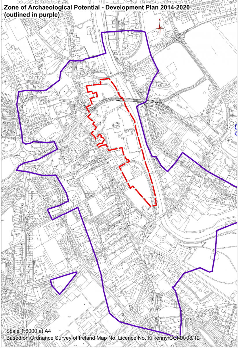
The Masterplan area is located in the heart of medieval Kilkenny and is located within the Zone of Archaeological Potential for Kilkenny City (see Figure 3.2). The site encompasses a number of significant heritage structures including:
St Francis’ Abbey (National Monument)
City Walls (National Monument)
Evans Turrett (National Monument)
Woollen Mills (Protected structure)
Tea / Pleasure Houses (Protected Structures)
Bull Inn (Recorded Monument)
Architectural Heritage
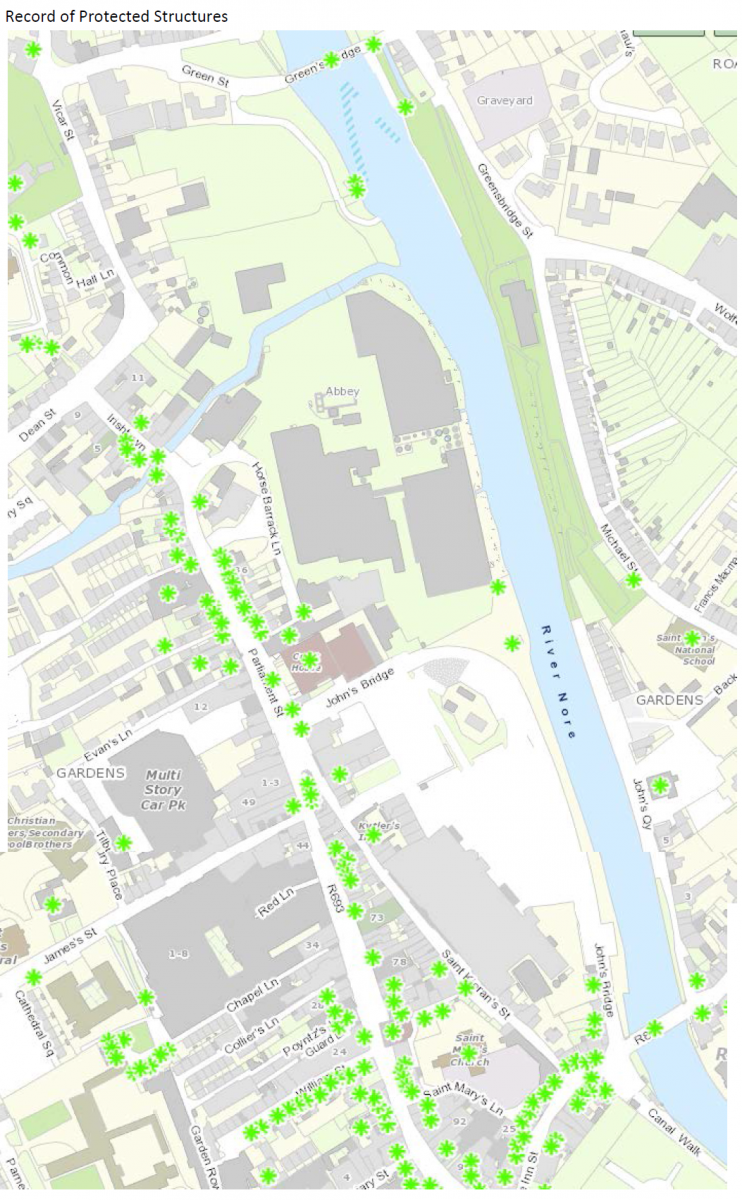
A “Record of Protected Structures” is a record, required to be included in every Development Plan, of every structure which, in the opinion of the planning authority, is of special architectural, historical, archaeological, artistic, cultural, scientific, social or technical interest and which forms part of the architectural heritage within the functional area of the planning authority. Entries to the Record of Protected Structures within and adjacent to the Masterplan area are mapped on Figure 3.3.
3.10 Landscape
The Masterplan area comprises an area of 8.25 hectares or 20.4 acres which is currently inaccessible to the public and lies at the heart of the medieval core of Kilkenny City Centre. The topography of the site is generally flat with the ground gently sloping from west to east down to the river. The ground is generally level from south to north, with the ground levels rising at the junction with Greens Bridge.
The River Breagagh and sections of the old city wall traverse the site on an east west axis and effectively subdivide the site into two distinct quarters of very different character. The southern quarter contains the majority of the existing buildings and is quite industrial in nature with large industrial and warehouse buildings surrounded by extensive concrete marshalling yards. The northern quarter is less developed and was primarily used by the Brewery for vehicular parking, truck washing, etc.
The most northerly section of the site is a parcel of land known as Sweeney’s Orchard. This would best be described as a disused back lot. The site is bordered to the south by Bateman Quay and the Market Yard. To the west lies Parliament Street, containing many three storeys over basement Georgian buildings, Horse Barack Lane and Vicar Street with predominantly two storey residential terraced buildings. To the north lies some residential properties and industrial units which are accessed from Green Street. To the east is the River Nore. The River Nore flows from north to south and divides the City into two distinct halves. The River is a predominant landscape feature in the City, providing amenity in the centre of the City.
There are several existing heritage structure within the site.
The current City Development Plan 2014-2020 lists the following views and prospects for protection in the vicinity of the Masterplan area:
3. View (north) of River Nore and Linear Park from Greensbridge
5. View of St. Mary’s Cathedral, Tholsel and St. Mary’s Church from No. 30‐35 Michael Street
6. View of St. Mary’s Cathedral from Kenny’s Well Road
7. Panoramic view from Dublin Road/Windgap Hill area to River Nore and city skyline
8. View of Castle Park, open countryside from Castle
12. View of Kilkenny Castle from John’s Bridge
3.11 Appropriate Assessment and Flood Risk Assessment
A Stage 2 Appropriate Assessment (AA) and a Flood Risk Assessment (FRA) have both been undertaken alongside the preparation of the Masterplan. The requirement for AA is provided under the EU Habitats Directive (Directive 1992/43/EEC). The requirement for FRA is provided under ‘The Planning System and Flood Risk Management Guidelines for Planning Authorities’ (DEHLG and OPW, 2009). The AA concluded that the Masterplan will not affect the integrity of the Natura 2000 network* and the FRA has facilitated the integration of flood risk management considerations into the Masterplan. The preparation of the Masterplan, SEA, AA and FRA has taken place concurrently and the findings of the AA and FRA have informed both the Masterplan and the SEA. All recommendations made by the AA and SEA were integrated into the Masterplan.
*Except as provided for in Section 6(4) of the Habitats Directive, viz. There must be:
(a) no alternative solution available;
(b) imperative reasons of overriding public interest for the plan/programme/project to proceed; and
(c) adequate compensatory measures in place.
3.12 Strategic Environmental Objectives
Strategic Environmental Objectives (SEOs) are methodological measures developed from policies which generally govern environmental protection objectives established at international, Community or Member State level e.g. the environmental protection objectives of various European Directives which have been transposed into Irish law and which are required to be implemented.
Table 3.1 Strategic Environmental Objectives
| Environmental Component | SEO Code | SEO |
| Biodiversity, Flora and Fauna | B1 | To ensure compliance with the Habitats and Birds Directives with regard to the protection of Natura 2000 Sites and Annexed habitats and species |
| B2 | To ensure compliance with Article 10 of the Habitats Directive with regard to the management of features of the landscape which - by virtue of their linear and continuous structure or their function act as stepping stones - are of significant importance for wild fauna and flora and/or essential for the migration, dispersal and genetic exchange of wild species |
|
| B3 | To avoid significant impacts on relevant habitats, species, environmental features or other sustaining resources and to ensure compliance with the Wildlife Acts 1976-2010 with regard to the protection of species listed on Schedule 5 of the principal Act | |
| Population and Human Health |
HH1 | To protect populations and human health from exposure to incompatible landuses |
| Soil | S1 | To avoid damage to the hydrogeological and ecological function of the soil resource |
| Water | W1 | To maintain and improve, where possible, the quality and status of surface waters |
| W2 | To prevent pollution and contamination of ground water | |
| W3 | To comply as appropriate with the provisions of the Flood Risk Management Guidelines | |
| Air and Climatic Factors | C1 | To reduce travel related emissions to air and to encourage modal change from car to more sustainable forms of transport |
| Material Assets | M1 | To serve new development with adequate and appropriate waste water treatment infrastructure |
| M2 | To serve new development with adequate drinking water that is both wholesome and clean | |
| M3 | To reduce waste volumes, minimise waste to landfill and increase recycling and reuse | |
| Cultural Heritage | CH1 | To protect archaeological heritage including entries to the Record of Monuments and Places and/or their context |
| CH2 | To protect architectural heritage including entries to the Record of Protected Structures and Architectural Conservation Areas and their context | |
| Landscape | L1 | To avoid significant adverse impacts on the landscape - especially with regard to protected views |
Section 4 Alternatives
4.1 Introduction
The SEA Directive requires that reasonable alternatives (taking into account the objectives and the geographical scope of the plan or programme) are identified, described and evaluated for their likely significant effects on the environment.
The description of the environmental baseline (both maps and text) and Strategic Environmental Objectives (SEOs) are used in the strategic evaluation of alternatives.
In considering the future development of the Masterplan site a number of strategic, high level alternatives were considered.
These are detailed below.
4.2 Description of Alternatives
Alternative 1: Redevelop the Brewery Site, and reuse of existing buildings on site (Mayfair, Brewhouse, & Maturation building) providing for a new City Quarter with linear park.
This would involve the upgrading and retrofitting of the existing buildings to a near zero energy building standard for use as third/fourth level education, office and other appropriate uses depending on demand and the provision of a linear park along the river Nore.
The following would be the key elements of this development strategy:
Mayfair and Brewhouse buildings retained and upgraded and retrofitted, other non-protected
buildings demolished;
Develop remaining land for mixed use development; and
Linear park provided along the river Nore from Bateman Quay to Greens Bridge.
Alternative 2: Redevelop the Brewery Site, without retaining the existing buildings, and provide for a new City Quarter with linear park.
This would involve the demolition of all existing industrial buildings and the provision of a linear park along the river Nore.
The following would be the key elements of this development strategy:
Demolition of all existing buildings (excluding St Francis Abbey & City Walls);
Develop the lands for mixed use development; and
Linear Park provided along the river Nore from Bateman Quay to Greens Bridge.
Alternative 3: Intensive redevelopment of the Brewery Site to maximise the development footprint incorporating mixed uses (e.g. retail, office, leisure and other commercial activity along with third level uses) providing for a new City Quarter.
This would involve maximizing the development potential of the site reducing the linear park to a minimum and intensifying the uses on the site.
The following would be the key elements of this development strategy:
Demolition of all existing buildings (after relevant structures are delisted from protection);
Develop (for mixed uses) buildings and structures to maximise development potential;
Linear park provided along the river Nore but minimised to allow increased development potential.
Alternative 4: Low intensity intervention with the majority of the Brewery Site devoted to a public park.
This would involve the retention of Mayfair, Brewhouse and Maturation building with the remainder of the area devoted to recreational use including a linear park along the river Nore from Bateman quay to Greens Bridge.
The following would be the key elements of this development strategy:
Mayfair and Brewhouse buildings retained and upgraded and retrofitted, other non-protected buildings demolished;
Linear park provided along the river Nore from Bateman Quay to Greens Bridge; and
The remainder of the site developed as a public park.
4.3 Evaluation of Alternatives
A number of potentially significant adverse effects, if unmitigated, are common to all alternatives as each alternative provides for the development of the Masterplan site. These effects would be present to varying degrees and are as a result of activities including demolition, construction and usage including that arising from recreation and tourism.
Table 4.1 Potentially Significant Adverse Effects common to all Alternatives
| Environmental/Component | Potential Significant Adverse Effect, if unmitigated |
| Biodiversity and Flora and Fauna |
Loss of/disturbance to biodiversity with regard to Natura 2000 Sites, including the River Barrow and River Nore candidate Special Area of Conservation and the River Nore Special Protection Area Loss of/disturbance to biodiversity with regard to ecological connectivity and non-designated biodiversity Loss of/disturbance to biodiversity with regard to listed species |
| Population and Human Health | Spatially concentrated deterioration in human health |
| Soil | Damage to the hydrogeological and ecological function of soil |
| Water | Potential interactions with the status of water bodies (River Nore, River Breagagh and groundwater) and entries to the WFD Register of Protected Areas, arising from: - Changes in quality, flow and/or morphology; and - Increases in outflow at waste water treatment plant as a result of increases in population. |
| Flood Risk | Increase in flood risk |
| Material Assets | The need to provide adequate and appropriate water services (it is the function of Irish Water to provide for such needs) Increases in waste levels |
| Archaeological and Architectural Heritage |
Effects on the Zone of Archaeological Potential, St. Francis Abbey, Kilkenny Town wall, Evans Tower, entries to the Record of Monuments and Places and other archaeological heritage Effects on entries to the Records of Protected Structures, National Inventory of Architectural Heritage and Architectural Conservation Areas (St. Canice’s ACA and City Centre ACA) and other architectural heritage |
| Landscape | Occurrence of adverse visual impacts especially with respect to protected views and prospects |
Alternative 1
Alternative 1 facilitates the reuse and regeneration of brownfield lands thereby contributing towards a higher efficiency of land utilisation, sustainable mobility and a reduction in the need to develop greenfield lands on the outskirts of the City. By reducing the need to develop greenfield lands, potential adverse effects upon environmental components including ecology, landscape designations, architectural and archaeological heritage and soil will be avoided. The site also has access to existing water and other services. This alternative also allows for a greater number journeys via sustainable transport modes and would be likely to contribute towards associated positive environmental effects on overall greenhouse gas emissions, energy usage and air and noise emissions.
Potential conflicts associated with the redevelopment of the site under this alternative - including demolition of certain non-protected buildings and construction of new buildings and other development – are less than those under Alternatives 2 and 3.
This alternative provides for the retention of designated archaeological and architectural heritage. In response to the Architectural Heritage Protection - Guidelines for Planning Authorities’ aspiration to reuse existing buildings Alternative 1 proposes to retain the Mayfair and Brewhouse Buildings. The Brewhouse building is not a Protected Structure but it has been identified both as having architectural merit as an industrial building of its type and as not being replicated elsewhere in the City. The Mayfair building is identified as having merit with respect to social heritage. Renovation and re-use of the Mayfair and Brewhouse buildings accords with the principle of sustainable re-use of existing building assets and facilitates the protection of non-designated architectural heritage.
Once undertaken in compliance with the provisions of the Habitats Directive, the development of the Linear Park from Bateman Quay to Greens Bridge would facilitate contributions towards sustainable mobility and enhancement of ecological connectivity along the banks of the Nore.
Alternative 2
The evaluation for Alternative 2 is the same as that provided for Alternative 1 with one difference. Alternative 2 provides for the demolition of the Mayfair and Brewhouse Buildings. The Brewhouse building is not a Protected Structure but it has been identified both as having architectural merit as an industrial building of its type and as not being replicated elsewhere in the City. The Mayfair building is identified as having merit with respect to social heritage. Demolition of these buildings potentially conflicts with the protection of non-designated architectural heritage.
Alternative 3
Alternative 3 facilitates the reuse and regeneration of brownfield lands thereby contributing towards a higher efficiency of land utilisation, sustainable mobility and a reduction in the need to develop greenfield lands on the outskirts of the City - it does this to a higher intensity than is the case under Alternatives 1 and 2, maximising the development footprint and associated positive effects. By reducing the need to develop greenfield lands, potential adverse effects upon environmental components including ecology, landscape designations, architectural and archaeological heritage and soil will be avoided. The site also has access to existing water and other services. This alternative also allows for a greater number journeys via sustainable transport modes and would be likely to contribute towards associated positive environmental effects on overall greenhouse gas emissions, energy usage and air and noise emissions.
Due to the intensity of the development provided for by this alternative, potential conflicts – and any residual effects – associated with the redevelopment of the site under are greater than those likely under Alternatives 1 and 2. This includes loss of cultural heritage (including context and associated interactions with landscape) as a result of the demolition of all existing buildings (after relevant structures delisted are from protection).
The development of the Linear Park under this alternative – which would be required to be developed in compliance with the Habitats Directive – would be minimised and would be unlikely to contribute towards enhancement of ecological connectivity along the banks of the Nore.
Alternative 4
Alternative 4 would not contribute towards efficiency of land utilisation. Under this alternative there would be a failure to maximise sustainable mobility (and associated interactions with greenhouse gas emissions, energy usage and air and noise emissions).
This alternative would not provide for the reduction in the need to develop greenfield lands on the outskirts of the City (as would be provided for by Alternatives 1, 2 and 3) – as a result the avoidance of adverse effects upon environmental components including ecology, landscape designations, architectural and archaeological heritage and soil would not be achieved.
There would be potential conflicts associated with the redevelopment of the site under this alternative - including the demolition of buildings and development of a public park.
This alternative provides for the retention of designated archaeological and architectural heritage. In response to the Architectural Heritage Protection - Guidelines for Planning Authorities’ aspiration to reuse existing buildings Alternative 4 proposes to retain the Mayfair and Brewhouse Buildings. The Brewhouse building is not a Protected Structure but it has been identified both as having architectural merit as an industrial building of its type and as not being replicated elsewhere in the City. The Mayfair building is identified as having merit with respect to social heritage. Retention of these buildings facilitates the protection of non-designated architectural heritage.
Once undertaken in compliance with the provisions of the Habitats Directive, the development of the Linear Park from Bateman Quay to Greens Bridge would facilitate contributions towards sustainable mobility and enhancement of ecological connectivity along the banks of the Nore.
The Selected Alternative for the Masterplan and the Variation
The selected alternative for the Masterplan and the Variation* is Alternative 1.
This alternative facilitates the improvements in various environmental components by accommodating new development on the Masterplan site thereby reducing the need for new greenfield development on the outskirts of the City. This alternative also allows for a greater number journeys via sustainable transport modes and would be likely to contribute towards associated positive environmental effects on overall greenhouse gas emissions, energy usage and air and noise emissions. Potential conflicts associated with the redevelopment of the site under this alternative - including demolition of certain non-protected buildings and construction of new buildings and other development – are less than those under the other alternatives.
There are potentially significant adverse effects arising from the alternative and these are tabulated overleaf. These effects will be mitigated by, inter alia, the various provisions which have been integrated into the Masterplan. These mitigating provisions together with the contribution that the Masterplan will make towards sustainable mobility will mean that the selected alternative facilitates various significant positive effects upon environmental components.
A number of design options were considered to varying degrees at various stages throughout the Masterplan preparation process. These considerations were informed by the environmental sensitivities which are presented in this SEA Environmental Report and other associated Masterplan documents.
By complying with appropriate mitigation measures – including those which have been integrated into the Draft Masterplan – potentially significant adverse environmental effects which could arise as a result of implementing the Masterplan would be likely to be avoided, reduced or offset.
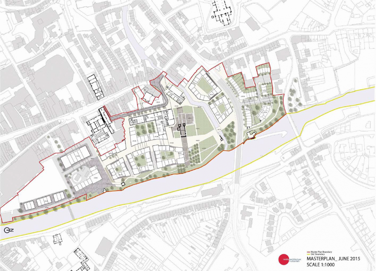
Table 4.2 overleaf details the following with respect to the selected alternative which was developed for the Masterplan and placed on public display (this final design is provided at Figure 3.1):
Significant positive effects facilitated;
Potentially significant adverse effects, if unmitigated; and
Potential significant Residual Adverse Effect once all mitigation is adhered to.
*It is intended to place the Masterplan on a statutory footing by way of Variation No. 1 to the City Development Plan (this
Proposed Variation and associated SEA and AA documents have been placed on public display at the same time as the Draft
Masterplan and its associated SEA and AA documents).
Table 4.2 Significant positive effects facilitated, potentially significant adverse effects, if unmitigated, and residual non-significant adverse effects
| Environmental/Component | Significant Positive Effect facilitated | Potentially Significant Adverse Effect, if unmitigated | Potential Significant Residual Adverse Effect once all mitigation is adhered to |
| Biodiversity and Flora and Fauna |
Contribution towards the protection of designated ecological sites (River Barrow and River Nore candidate Special Area of Conservation and the River Nore Special Protection Area) and ecological connectivity Contribution towards enhancement of ecological connectivity along the banks of the Nore Reduces need to develop greenfield lands (with associated impacts upon biodiversity elsewhere |
Loss of/disturbance to biodiversity with regard to Natura 2000 Sites, including the River Barrow and River Nore candidate Special Area of Conservation and the River Nore Special Protection Area Loss of/disturbance to biodiversity with regard to ecological connectivity and non-designated biodiversity Loss of/disturbance to biodiversity with regard to listed species |
None |
| Population and Human Health | Contribution towards the protection of human health as a result of contributing towards the protection of environmental vectors, especially air |
Spatially concentrated deterioration in human health |
Flood related risks remain due to uncertainty with regard to extreme weather events |
| Soil | Reduces need to develop greenfield lands (with associated impacts upon soil elsewhere) |
Damage to the hydrogeological and ecological function of soil |
None |
| Water | Contribution towards the protection of status of surface and ground waters |
Potential interactions with the status of water bodies (River Nore, River Breagagh and groundwater) and entries to the WFD Register of Protected Areas7, arising from: - Changes in quality, flow and/or morphology; and - Increases in outflow at waste water treatment plant as a result of increases in population. Increase in flood risk |
Flood related risks remain due to uncertainty with regard to extreme weather events |
| Air and Climatic Factors and Sustainable Transport | Contribution towards a shift from car to more sustainable and non-motorised transport modes Contribution towards managing traffic flows and associated adverse effects on air quality Contribution towards reductions in travel related greenhouse gas and other emissions to air Contribution towards reduction in energy usage |
Failure to contribute towards sustainable transport and associated impacts (energy usage and emissions to air including noise and greenhouse gases) |
None |
| Material Assets | Enhances public assets Facilitates provision of water services and waste management |
The need to provide adequate and appropriate water services (it is the function of Irish Water to provide for such needs) Increases in waste levels |
Residual wastes to be disposed of in line with higher level waste management policies |
| Archaeological and Architectural Heritage |
Contribution towards the protection of architectural and archaeological heritage and its context by facilitating compliance with relevant legislation Reduces need to develop greenfield lands (with associated impacts upon architectural and archaeological heritage elsewhere) |
Effects on the Zone of Archaeological Potential, St. Francis Abbey, Kilkenny Town wall, Evans Tower, entries to the Record of Monuments and Places and other archaeological heritage Effects on entries to the Records of Protected Structures, National Inventory of Architectural Heritage and Architectural Conservation Areas (St. Canice’s ACA and City Centre ACA) and other architectural heritage |
Potential alteration to the context and setting of designated cultural heritage however these will occur in compliance with provisions of the Masterplan and relevant legislation. Potential loss of unknown archaeology however this loss will be mitigated by measures which have been integrated into the masterplan |
| Landscape | Contribution towards the protection of landscape designations by facilitating compliance with City Development Plan Opens up new views Reduces need to develop greenfield lands (with associated impacts upon landscapes elsewhere) |
Occurrence of adverse visual impacts especially with respect to protected views and prospects |
None |
Section 5 Assessment of Draft Masterplan Provisions
5.1 Overall Findings
The overall findings of the SEA are that:
The Council have integrated all recommendations arising from the SEA, Appropriate Assessment and Flood Risk Assessment processes into the Masterplan, facilitating compliance of the Masterplan with various European and National legislation and Guidelines relating to the protection of the environment and the achievement of sustainable development.
The Masterplan facilitates the reuse and regeneration of brownfield lands thereby contributing towards a higher efficiency of land utilisation, sustainable mobility and a reduction in the need to develop greenfield lands on the outskirts of the City. By reducing the need to develop greenfield lands, potential adverse effects upon ecology, landscape designations, architectural and archaeological heritage and soil will be avoided. By contributing towards sustainable mobility, the Masterplan would be likely to contribute towards compliance with targets relating to greenhouse gas emissions, energy usage and air and noise emissions.
Some Masterplan provisions would be likely to result in significant positive effects such as contributions towards achieving sustainable mobility and the protection of ecology, archaeological heritage and the status of waters.
Some Masterplan provisions would have the potential to result in significant negative environmental effects however these effects will be mitigated by mitigation measures, including those which have been integrated into the Masterplan.
5.2 Potential Adverse Effects and Residual Effects
Environmental impacts which occur, if any, will be determined by the nature and extent of multiple or individual projects and site specific environmental factors. The potentially significant adverse environmental effects arising from implementation of the Masterplan if unmitigated – are detailed on Table 4.2. Potential significant residual adverse effects likely to occur - considering the extent of detail provided by the Masterplan and assuming that all mitigation measures are complied with by development - are identified for each of the environmental components on Table 5.1 below.
Table 5.1 Potential Significant Residual Adverse Effects
| Environmental/ Component | Potential Significant Residual Adverse Effect once all mitigation is adhered to |
| Biodiversity and Flora and Fauna | None |
| Population and Human Health | Flood related risks remain due to uncertainty with regard to extreme weather events |
| Soil | None |
| Water | Flood related risks remain due to uncertainty with regard to extreme weather events |
| Air and Climatic Factors and Sustainable Transport |
None |
| Material Assets | Residual wastes to be disposed of in line with higher level waste management policies |
| Archaeological and Architectural Heritage |
Potential alteration to the context and setting of designated cultural heritage however these will occur in compliance with provisions of the Masterplan and relevant legislation. Potential loss of unknown archaeology however this loss will be mitigated by measures which have been integrated into the Masterplan |
| Landscape | None |
Section 6 Mitigation and Monitoring Measures
6.1 Mitigation
The Draft Masterplan has been prepared with environmental considerations being one of the key Masterplan informants and influences.
The undertaking of Strategic Environmental Assessment, Appropriate Assessment and Flood Risk Assessment has further informed the Draft Masterplan. By integrating related recommendations into the Masterplan, the Council have ensured that both the beneficial environmental effects of implementing the Masterplan have been and will be maximised and that potential adverse effects have been and will be avoided, reduced or offset.
The text of the Masterplan outlines how the various Strategies in the Masterplan will contribute towards environmental protection and sustainable development. Strategies such as the Connectivity and Movement Strategy, the Conservation and Heritage Strategy, the Urban Design Strategy and the Sustainability Strategy would facilitate contributions towards the protection of various environmental components and sustainable development.
In addition to these Strategies, proposals for development within the Masterplan area must comply as appropriate with the relevant provisions included within the Kilkenny City Development Plan 2014-2020. A number of City Plan provisions which contribute towards environmental protection and sustainable development are reproduced in Appendix A to the Masterplan document. Proposals for development are required to adhere to these and the other provisions contained within the City Plan.
6.2 Monitoring
The SEA Directive requires that the significant environmental effects of the implementation of plans and programmes are monitored. The monitoring of potential significant effects (see Table 4.2) within the Masterplan area will be undertaken in conjunction with the monitoring programme for Proposed Variation No. 1 to the Kilkenny City Development Plan. The monitoring measures are the same as those included as part of the monitoring programme detailed for Proposed Variation No. 1.
Monitoring can enable, at an early stage, the identification of unforeseen adverse effects and the undertaking of appropriate remedial action.
A stand-alone Monitoring Report on the significant environmental effects of implementing Proposed Variation No. 1 to the Kilkenny City Development Plan and the Masterplan will be prepared in 2017 and again in 2019. The Kilkenny City Development Plan will be reviewed in 2019-2020 and monitoring arrangements will be re-examined at this stage. Monitoring reports should address the indicators set out below.
The Council is responsible for the ongoing review of indicators and targets, collating existing relevant monitored data, the preparation of monitoring evaluation report(s), the publication of these reports and, if necessary, the carrying out of corrective action.