Section 4 Environmental Baseline
4.1 Introduction
The SEA Directive requires that the information on the baseline environment is focused upon the relevant aspects of the environmental characteristics of areas likely to be significantly affected and the likely evolution of the current environment in the absence of the Plan. Being consistent with the strategic provisions of the Plan, this section provides a strategic description of aspects of environmental components which have the greatest potential to be affected by implementation of the Plan, if unmitigated.
Article 5 of the SEA Directive states that the report shall include the information that may reasonably be required taking into account:
- Current knowledge and methods of assessment;
- The contents and level of detail in the plan or programme and its stage in the decision-making process; and
- The extent to which certain matters are more appropriately assessed at different levels in that process in order to avoid duplication of the assessment.
What this means in practice is, inter alia, that SEA involves collating currently available, relevant environmental data; it does not require major new research. Where data deficiencies or gaps exist, this should be acknowledged in the report.
With respect to the likely evolution of the environment in the absence of the Plan:
1. The 2009-2020 Callan Local Area Plan contains provisions which contribute towards environmental protection and sustainable development within Callan town.
2. Higher level environmental protection objectives are also included in the County Development Plan 2014-2020 and various EU Directives and transposing Irish Regulations.
Cumulative effects occur as a result of the addition of many small impacts to create one larger, more significant, impact.
Such adverse effects could include:
- Loss of biodiversity with regard to Natura 2000 Sites and Annexed habitats and species;
- Loss of biodiversity with regard to ecological connectivity and stepping stones;
- Loss of biodiversity with regard to designated sites including Wildlife Sites and species listed on Schedule 5 of the Wildlife Act 1976;
- Spatially concentrated deterioration in human health;
- Adverse impacts on the hydrogeological and ecological function of the soil resource;
- Adverse impacts upon the status of water bodies arising from changes in quality, flow and/or morphology;
- Increase in the risk of flooding;
- Failure to provide adequate and appropriate waste water treatment;
- Failure to comply with drinking water regulations and serve new development with adequate drinking water that is both wholesome and clean;
- Increases in waste levels;
- Failure to contribute towards sustainable transport and associated impacts;
- Effects on entries to the Record of Monuments and Places and other archaeological heritage;
- Effects on entries to the Records of Protected Structures and other architectural heritage; and
- Occurrence of adverse visual impacts.
4.2 Biodiversity and Flora and Fauna
4.2.1 Natura 2000
Candidate Special Areas of Conservation (cSACs) have been selected for protection under the European Council Directive on the conservation of natural habitats and of wild fauna and flora (92/43/EEC) by the (former) Department of the Environment, Heritage and Local Government due to their conservation value for habitats and species of importance in the European Union.
Special Protection Areas (SPAs) have been selected for protection under the 1979 European Council Directive on the Conservation of Wild Birds (79/409/EEC) due to their conservation value for birds of importance in the European Union.
SPAs, along with SACs, comprise Ireland’s Natura 2000 network – part of an EU-wide network of protected areas established under the Habitats Directive.
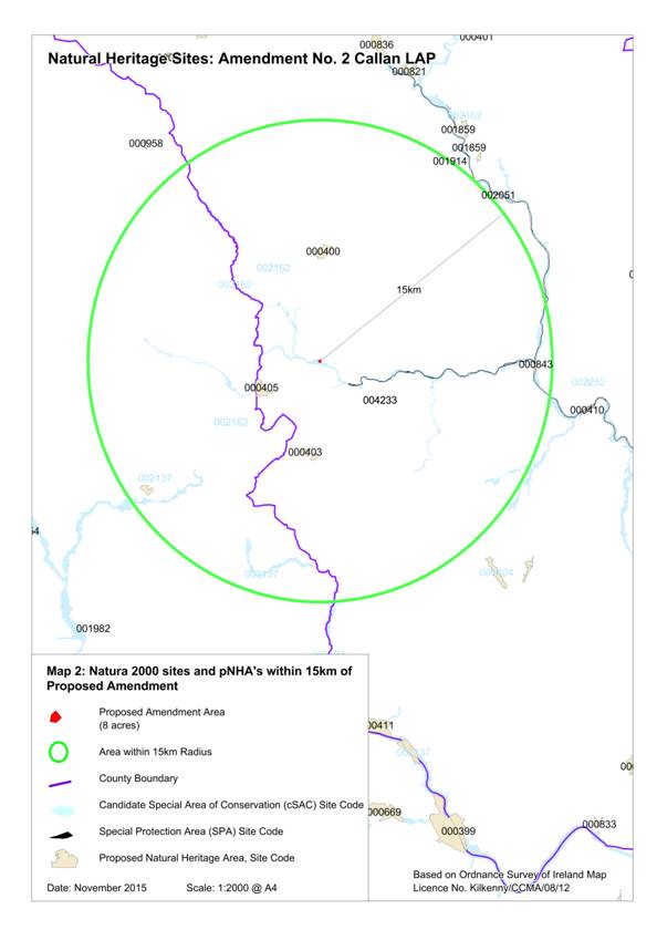
The River Barrow and River Nore candidate Special Area of Conservation (cSAC) (code 002162) is located immediately beside the plan area (King’s River). The River Nore SPA (code 004233) is approx. 2.1km to the east of the amendment site. These Natura 2000 sites in the vicinity of the Plan area are shown on Figure 4.1. These are also listed on Table 4.1.
Table 4.1 Natura 2000 sites within 15km of the Plan area
|
Site Name |
Qualifying Feature |
Threats to Site Integrity |
|
|
002162 |
River Barrow and River Nore cSAC |
Annex I Habitats [1130] Estuaries [1140] Tidal Mudflats and Sandflats [1310] Salicornia mud [1320] Spartina Swards [1330] Atlantic Salt Meadows [1410] Mediterranean Salt Meadows [3260] Floating River Vegetation [4030] Dry heath [6430] Hydrophilous Tall Herb [7220] Petrifying springs* [91A0] Old Oak Woodlands [91E0] Residual Alluvial Forests* Annex II Species [1016] Desmoulin’s whirl snail (Vertigo moulinsiana) [1029] Freshwater pearl mussel (Margaritifera margaritifera) [1092] White-clawed crayfish (Austropotamobius pallipes) [1095] Sea lamprey (Petromyzon marinus) [1096] Brook lamprey (Lampetra planeri) [1099] River lamprey (Lampetra fluviatilis) [1102] Allis shad (Alosa alosa) [1103] Twaite shad (Alosa fallax fallax) [1106] Salmon (Salmo salar) [1355] Otter (Lutra lutra) [1421] Killarney fern (Trichomanes speciosum) [1990] Pearl mussel (Margaritifera durrovensis) |
The principle threats to the River Barrow and River Nore cSAC are pollution caused by increased fertiliser application, sewage and industrial waste. Species such as Freshwater Pearl Mussel are highly susceptible to siltation of water course and proposed developments in the vicinity of the cSAC may give rise to siltation and run-off of pollutants. The river has also been designated for its population of otter, a species vulnerable to the felling of mixed wood and scrub. Otters may become displaced due to disturbance during the development of unmitigated residential areas in proximity to the cSAC. |
|
002137 |
Lower River Suir cSAC |
Annex I Habitats [1330] Atlantic Salt Meadows [1410] Mediterranean Salt Meadows [3260] Floating River Vegetation [6430] Hydrophilous Tall Herb [91A0] Old Oak Woodlands [91E0] Residual Alluvial Forests* [91J0] Yew Woodlands* Annex II Species [1029] Freshwater pearl mussel (Margaritifera margaritifera) [1092] White-clawed crayfish (Austropotamobius pallipes) [1095] Sea lamprey (Petromyzon marinus) [1096] Brook lamprey (Lampetra planeri) [1099] River lamprey (Lampetra fluviatilis) [1102] Allis shad (Alosa alosa) [1103] Twaite shad (Alosa fallax fallax) [1106] Salmon (Salmo salar) [1355] Otter (Lutra lutra) |
Water quality of this site is vulnerable to enrichment from surrounding agricultural activities and commercial and private developments near the river edge. Infilling and drainage threatens the continued presence of the rare plant species Hordeum secalinum and Groenlandia densa. Drainage in the catchment results in flash floods which can have a negative impact on the many Annex II species present. Any further planting or spread of exotic species would be damaging to the existing woodland habitats. |
|
004233 |
River Nore SPA |
[A229] Kingfisher (Alcedo atthis) |
There are no reported threats to this SPA. Kingfisher would be vulnerable to disturbance during the breeding season. They nest within burrows on river banks. |
A Stage 2 Appropriate Assessment was undertaken on the Plan as a result of potential impacts arising.
4.2.2 Proposed Natural Heritage Area
Natural Heritage Areas (NHAs) are designated due to their national conservation value for ecological and/or geological/geomorphological heritage. They cover nationally important semi-natural and natural habitats, landforms or geomorphological features, wildlife plant and animal species or a diversity of these natural attributes. NHAs are designated under the Wildlife (Amendment) Act 2000. Proposed NHAs (pNHA) were published on a non-statutory basis in 1995, but have not since been statutorily proposed or designated.
There are no NHA’s or pNHA’s occurring inside the Plan boundary. The nearest NHA’s are Kyleadohir Wood Nature Reserve (code 000405), located approx. 3.6km to the south west, and Ballykeeffe Woodland (code 000400), located approx. X km to the north east: both are listed in Table 4.2 and mapped on Figure 4.1.
Table 4.2 NHAs and pNHAs in the vicinity of the Plan area
|
Natural Heritage Areas |
||
|
Designation |
Code |
Site Name |
|
NHA |
405 |
Kyleadohir Wood Nature Reserve |
|
pNHA |
400 |
Ballykeeffe Woodland |
Figure 4.1 cSACs, SPAs and pNHA’s in the vicinity of the Amendment area
4.2.3 Water Framework Directive Registers of Protected Areas
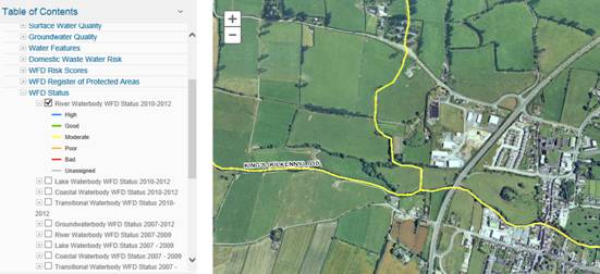
According to the EPA WFD Status record, groundwater underlying the Plan area is identified as being of ‘good’ status and the quality of the King’s River[4] 2010-2012 is ‘moderate’. This is illustrated in Figure 4.2 below.
Figure 4.2 River Waterbody Status 2010-2012, Source EPA
4.2.4 CORINE Land Cover Mapping
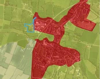
CORINE land cover mapping[5] for Callan town for the year 2012 is shown on Figure 4.3. The type of cover for the area of the proposed Amendment is ‘Pastures’. The main type of cover in Callan Town is ‘Discontinuous Urban Fabric’ - indicative of the built area of the town.
Figure 4.3 CORINE Land Cover Data 2012 Source: EPA (2015)
|
4.2.5 Ecological Networks and Connectivity
Ecological networks are important in connecting areas of local biodiversity with each other and with nearby designated sites so as to prevent islands of habitat from being isolated entities. They are composed of linear features, such as treelines, hedgerows and rivers/streams, which provide corridors or stepping stones for wildlife species moving within their normal range. They are important for the migration, dispersal and genetic exchange of species of flora and fauna particularly for mammals, especially for bats and small birds and facilitate linkages both between and within designated ecological sites, the non-designated surrounding countryside and the town.
Important ecological networks comprise a variety of features including the King’s River that flows through the town, various agricultural lands, stands of trees and hedgerows.
The current County Development Plan 2014-2020 contains objectives and Development Management Standards in relation to protection of ecological networks (See Section 8.3 of this report).
4.2.6 Other Protected Species/Habitats
In addition to certain species and habitats already mentioned above, other species are protected under law wherever they occur, such as:
· ‘Protected Species and natural habitats’ as defined in the Environmental Liability Directive (2004/35/EC) and European Communities (Environmental Liability) Regulations 2008 including annexed habitats and species listed under Annexes I, II and IV of the EU Habitats Directive and Annex I of the EU Birds Directive;
· Species/Habitats legally protected under the Flora Protection Order in the Wildlife (Amendment) Act 2000;
· Other species of flora and fauna and their key habitats which are protected under the Wildlife Acts 1976-2000 including all native mammals; and
· Stepping stones and ecological corridors including nature conservation sites (other than Natura 2000 sites), habitats and species locations covered by Article 10 of the Habitats Directive.
4.2.7 Existing Problems
Previous developments in the town such as residential, commercial and transportation have resulted in loss of biodiversity and flora and fauna however legislative objectives governing biodiversity and fauna were not identified as being currently conflicted with.

4.3 Population and Human Health
4.3.1 Population
The population of Callan town (both Urban and Rural CSO areas) was recorded as being 2,330 in 2011. This was up from 1,771 in 2006.
4.3.2 Human Health
Human health has the potential to be impacted upon by environmental vectors (i.e. environmental components such as air, water or soil through which contaminants or pollutants, which have the potential to cause harm, can be transported so that they come into contact with human beings).Hazards or nuisances to human health can arise as a result of exposure to these vectors arising from incompatible adjacent land uses for example. These factors have been considered with regard to the description of: the baseline of each environmental component; and the identification and evaluation of the likely significant environmental effects of implementing the Plan.
4.3.3 Existing Problems
The Strategic Flood Risk Assessment (SFRA) undertaken alongside the preparation of the Plan has identified lands that are at elevated levels of flood risk within the Plan area. The SFRA has facilitated the integration of flood risk management considerations into the Plan. Other issues relating to drinking water and waste water treatment are discussed in detail in Section 4.7.
4.4 Soil
Soil is the top layer of the earth’s crust. It is formed by mineral particles, organic matter, water, air and living organisms. Soil can be considered as a non-renewable natural resource because it develops over very long timescales. It is an extremely complex, variable and living medium and performs many vital functions including: food and other biomass production, storage, filtration and transformation of many substances including water, carbon, and nitrogen. Soil has a role as a habitat and gene pool, serves as a platform for human activities, landscape and heritage and acts as a provider of raw materials. Such functions of soil are worthy of protection because of their socio-economic as well as environmental importance. Soils in any area are the result of the interaction of various factors, such as parent material, climate, vegetation and human action.
To date, there is no Directive which is specific to the protection of soil resources. However, there is currently an EU Thematic Strategy on the protection of soil which includes a proposal for a Soil Framework Directive which proposes common principles for protecting soils across the EU.
Soil types, as classified by Teagasc in co-operation with the Forest Service, EPA and GSI, are mapped on Figure 4.2. The underlying soil type of the amendment area is classified as ‘Acid brown earths – Brown Podzolics’.
4.4.1 County Geological Sites
The Geological Survey of Ireland in partnership with Kilkenny County Council and Kilkenny Heritage Forum carried out an audit of the County Geological Sites in Kilkenny in 2007. The resulting report was an action of the County Kilkenny Heritage Plan.
There are no County Geological Sites within the Amendment Area. The nearest County geological Sites are mapped on Figure 4.7.
The underlying rock type in Callan town is generally ‘Carboniferous’, and the plan amendment area is identifiable as ‘dark shaly micrite, peloidal limestone’.
4.4.2 Existing Problems
Legislative objectives governing soil were not identified as being conflicted with.
Table 4.3 County Geological Sites near to Plan area
|
Site Code in CDP |
Geological Site name |
County |
Site Description |
Geological Features |
Designation |
|
4 |
Ballykeefe Quarry |
Kilkenny |
Disused Quarries exposing slate |
A well exposed section of fossiliferous Lower Carboniferous limestone within the Lower Carboniferous Ballyadams Formation. |
County Geological Site |
|
19 |
Rathduff (Bayley) King’s River |
Kilkenny |
Exposed limestone road cutting (M9) |
County Geological Site |
|
|
17 |
Windgap Artesian Borehole |
Kilkenny |
Artesian Well |
Such wells get their water supply from confined aquifers, containing groundwater that flows upwards, against gravity, without need for a pump. |
County Geological Site |
Figure 4.2 Soil Type
Source: Teagasc, GSI, Forest Service & EPA (2006) Soils and Subsoils Class
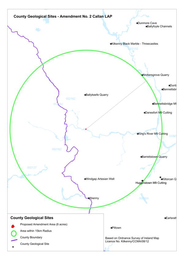
Figure 4.3 County Geological Sites in Plan area, Source: Kilkenny County Council
4.5 Water
4.5.1 Potential Pressures on Water Quality
Human activities, if not properly managed, can cause deterioration in water quality. Pressures exerted by human activities include the following:
· Sewage and other effluents discharged to waters from point sources, e.g. pipes from treatment plants;
· Discharges arising from diffuse or dispersed activities on land;
· Abstractions from waters; and
· Structural alterations to water bodies.
A point source pressure has a recognisable and specific location at which pollution may originate. Examples of significant point source pressures include direct discharges from waste water treatment plants, licensed discharges from industrial activities, landfills, contaminated lands (e.g. disused gas works) and mines.
4.5.2 The Water Framework Directive
4.5.2.1 Introduction and Requirements
Since 2000, Water Management in the EU has been directed by the Water Framework Directive 2000/60/EC (WFD). The WFD requires that all Member States implement the necessary measures to prevent deterioration of the status of all waters - surface, ground, estuarine and coastal - and protect, enhance and restore all waters with the aim of achieving “good status” by 2015. All public bodies are required to coordinate their policies and operations so as to maintain the good status of water bodies which are currently unpolluted and improve polluted water bodies to good status by 2015.
4.5.2.2 River Basin Districts and Water Bodies
For the purpose of implementing the WFD, Ireland has been divided into eight River Basin Districts (RBDs) or areas of land that are drained by a large river or number of rivers and the adjacent estuarine/coastal areas. The management of water resources is on these river basin districts.
Callan falls within the South Eastern RBD.
Within each river basin district - for the purpose of assessment, reporting and management - water has been divided into groundwater, rivers, lakes, estuarine waters and coastal waters which are in turn divided into specific, clearly defined water bodies.
4.5.2.3 River Basin Management Plans
Local Authorities, including Kilkenny County Council, have prepared the South Eastern River Basin Management Plan 2009-2015 which is implemented in order to help protect and improve the status of waters. The Management Plans provide specific policies for individual river basins in order to implement the requirements of the WFD.
4.5.3 Surface Water
4.5.3.1 WFD Surface Water Status
The WFD defines ‘surface water status’ as the general expression of the status of a body of surface water, determined by the poorer of its ecological status and its chemical status. Thus, to achieve ‘good surface water status’ both the ecological status and the chemical status of a surface water body need to be at least ‘good’.
Ecological status is an expression of the structure and functioning of aquatic ecosystems associated with surface waters. Such waters are classified as of “good ecological status” when they meet Directive requirements.
Chemical Status is a pass/fail assignment with a failure defined by a face-value exceedance of an Environmental Quality Standards (EQS) for one or more Priority Action Substances (PAS) listed in Annex X of the Water Framework Directive (WFD). The EQS values for individual PAS substances are set at European level. Good surface water chemical status means that concentrations of pollutants in the water body do not exceed the environmental limit values specified in the Directive.
Figure 4.5 illustrates the surface water quality in the area of the proposed amendment, which is ‘good status’.
4.5.3.2 Quality of Rivers
River water quality is monitored by the EPA at a number of locations. The most recent data from the EPA identify the King’s River as ‘moderate’.
4.5.4 Ground Water
4.5.4.1 Introduction
Groundwater is stored in the void spaces in underground layers of rock, or aquifers. These aquifers are permeable, allowing both the infiltration of water from the soils above them and the yielding of water to surface and coastal waters. Groundwater is the part of the subsurface water that is in the saturated zone - the zone below the water table, the uppermost level of saturation in an aquifer at which the pressure is atmospheric, in which all pores and fissures are full of water.
4.5.4.2 WFD Groundwater Status
For groundwater bodies, the approach to classification is different from that for surface water. For each body of groundwater, both the chemical status and the quantitative must be determined. Both have to be classed as either good or poor. The WFD sets out a series of criteria that must be met for a body to be classed as good chemical and quantitative status.
The status of the groundwater underlying Callan is identified as being of ‘good’ status (Source: EPA).
4.5.4.3 Aquifer Productivity, Vulnerability and Protection
The Geological Survey of Ireland (GSI) databases illustrate that a National Gravel Aquifer (Draft Mao) underlies the site, and this is illustrated in Figure 4.4 below.
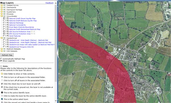
Figure 4.4 National Draft Gravel Aquifer Map, Source GSI.
4.5.5 Register of Protected Areas
The groundwater underlying both the town and surrounding area is listed on the RPA for Drinking Water (Groundwater) (Source EPA).
4.5.6 Flooding
4.5.6.1 Introduction
Flooding is an environmental phenomenon which, as well have causing economic and social impacts, could in certain circumstances pose a risk to human health.
4.5.6.2 EU Floods Directive
European Directive 2007/60/EC on the assessment and management of flood risks requires Member States to carry out a preliminary assessment by 2011 in order to identify the river basins and associated coastal areas at risk of flooding. For such zones, flood risk maps currently being finalised. Flood risk management plans focused on prevention, protection and preparedness will be finalised in 2016. The Office of Public Works has prepared Preliminary Flood Risk Assessment (PFRA) maps which identify areas where the risks associated with flooding might be significant. These areas, Areas for Further Assessment (AFAs), including Callan, are where more detailed assessment is required to more accurately assess the extent and degree of flood risk. Flood hazard and flood risk maps for AFAs will be finalised in 2015 and Flood Risk Management Plans will be finalised in 2016.
4.5.6.3 DEHLG Flood Risk Management Guidelines
In 2009 the DEHLG published The Planning System and Flood Risk Management Guidelines for Planning Authorities. These are aimed at ensuring a more consistent, rigorous and systematic approach which will fully incorporate flood risk assessment and management into the planning system. Planning authorities are required to undertake flood risk identification, assessment and management processes as appropriate when preparing land use plans and in the consideration of applications for planning permission.
4.5.6.4 Strategic Flood Risk Assessment
A Strategic Flood Risk Assessment (SFRA) has been undertaken alongside the preparation of the Plan. The requirement for SFRA is provided under ‘The Planning System and Flood Risk Management Guidelines for Planning Authorities’ (DEHLG and OPW, 2009). The preparation of the Plan, SEA and SFRA has taken place concurrently and the findings of the SFRA have informed both thePlan and the SEA. The SFRA has facilitated the integration of flood risk management considerations into the Plan.
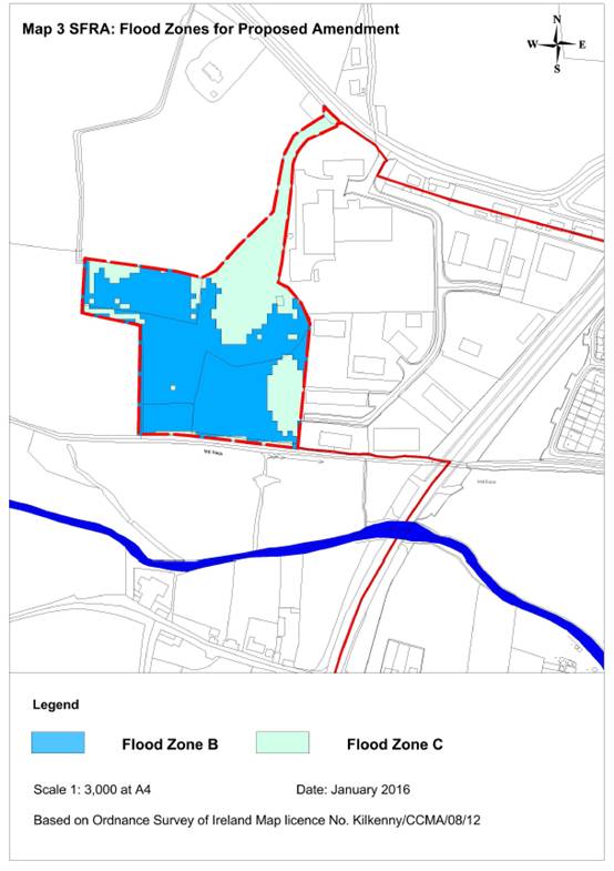
Further detail on lands that are at elevated levels of flood risk within the Plan area can be found within the SFRA which accompanies the Plan. The indicative Flood Zone B from that SFRA is reproduced in the Figure 4.10 overleaf.
4.5.7 Existing Problems
The SFRA has identified lands that are at elevated levels of flood risk within the Plan area and has facilitated the integration of flood risk management considerations into the Plan.

Figure 4.4 WFD Surface Water Status
Source: EPA (2011; datasets downloaded November, 2015)
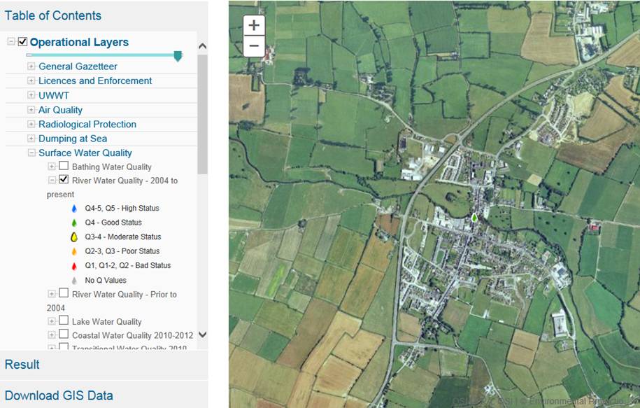
Figure 4.5 Surface Water Quality 2004-present.
Source: EPA (Various)
Figure 4.10 Proposed flood zones from SFRA.
4.6 Air and Climatic Factors
4.6.1 Ambient Air Quality
4.6.1.1 Introduction and Legislation
In order to protect human health, vegetation and ecosystems, EU Directives set down air quality standards in Ireland and the other Member States for a wide variety of pollutants. These pollutants are generated through fuel combustion, in space heating, traffic, electricity generation and industry and, in sufficient amounts, could affect the well-being of the areas inhabitants. The EU Directives include details regarding how ambient air quality should be monitored, assessed and managed.
The principles to this European approach are set out under the Air Quality Framework Directive 1996 as transposed into Irish law under the Environmental Protection Agency Act 1992 (Ambient Air Quality Assessment and Management) Regulations 1999 (SI No. 33 of 1999).
Four daughter Directives lay down limits or thresholds for specific pollutants. The first two of these directives cover: sulphur dioxide, nitrogen dioxide and oxides of nitrogen, particulate matter and lead; and, carbon monoxide and benzene. Two more daughter directives deal with: ozone; and polyaromatic hydrocarbons, arsenic, nickel, cadmium and mercury in ambient air.
4.6.1.2 Air Zones
In order to comply with the directives mentioned above, the EPA measures the levels of a number of atmospheric pollutants. For the purposes of monitoring in Ireland, four zones are defined in the Air Quality Standards Regulations 2002 (SI No. 271 of 2002). The main areas defined in each zone are:
· Zone A: Dublin Conurbation.
· Zone B: Cork Conurbation.
· Zone C: 21 Other cities and large towns including Galway, Limerick, Waterford, Clonmel, Kilkenny, Sligo, Drogheda, Wexford, Athlone, Ennis, Bray, Naas, Carlow, Tralee and Dundalk.
· Zone D: Rural Ireland, i.e. the remainder of the State - small towns and rural areas of the country - excluding Zones A, B and C.
Callan and its surrounds in County Kilkenny is located within Zone D where air quality is currently identified as being “good”. The EPA’s (2015) Air Quality in Ireland 2014 identifies that, overall, air quality in Ireland compares favourably with other EU Member States and continues to be of good quality relative to other EU countries.
4.6.2 Noise
Noise is unwanted sound. The Environmental Noise Regulations (SI No. 140 of 2006) transpose into Irish law the EU Directive 2002/49/EC relating to the assessment and management of environmental noise, which is commonly referred to as the Environmental Noise Directive or END. The END defines a common approach intended to avoid, prevent or reduce on a prioritised basis the harmful effects, including annoyance, due to exposure to environmental noise. The END does not set any limit value, nor does it prescribe the measures to be used in the action plans, which remain at the discretion of the competent authorities. Limit values are left to each member state. At this point in time, Ireland does not have any statutory limit values.
4.6.3 Climatic Factors
The key issue involving the assessment of the effects of implementing the plan on climatic factors relates to greenhouse gas emissions arising from transport. It is noted that the Plan contains a number of actions which respond to potential threats to environmental components arising from a changing climate.
Flooding (see Section 4.5.6) - is influenced by climatic factors. There are emerging objectives relating to climate adaptation and that there is likely to be future Guidance for climate change proofing of land use plan provisions as is flagged in the National Climate Change Adaptation Framework (DECLG, 2012). Some of these objectives might relate to green infrastructure which can achieve synergies with regard to the following:
- Provision of open space amenities;
- Sustainable management of water;
- Protection and management of biodiversity;
- Protection of cultural heritage; and
- Protection of protected landscape sensitivities.
In 2009, Ireland's greenhouse gas emissions decreased across all sectors due to the effects of the economic downturn with a decline in total emissions of 7.9 per cent. In 2010, Ireland's emissions fell by a further 0.7 per cent.
Ireland’s emissions profile has changed considerably since 1990, with the contribution from transport more than doubling and the share from agriculture reducing since 1998.
Travel is a source of:
- Noise;
- Air emissions; and
- Energy use 39% of Total Final Energy Consumption in Ireland in 2012 was taken up by transport, the largest take up of any sector)[6].
Land-use planning contributes to what number and what extent of journeys occur. By addressing journey time through land use planning and providing more sustainable modes and levels of mobility, noise and other emissions to air and energy use can be minimised. Furthermore, by concentrating populations, greenfield development - and its associated impacts - can be minimised and the cost of service provision can be reduced.
Between 2008 and 2011, Ireland's greenhouse gas emissions decreased across all sectors due to the effects of the economic downturn with emissions falling by 15.2% between 2008 and 2011. However, 2012 saw emissions rise by 1.2% when compared with 2011[7].
Maximising sustainable mobility will help Ireland meet its emission target for greenhouse gases under the 2020 EU Effort Sharing target which commits Ireland to reducing emissions from those sectors that are not covered by the Emissions Trading Scheme (e.g. transport, agriculture, residential) to 20% below 2005 levels. The EPA 2013 publication Ireland’s Greenhouse Gas Emission Projections 2012-2030, identifies that Ireland is on track to meet its commitment under the Kyoto Protocol, primarily, as a direct result of the recent economic downturn and economic outlook for the future. However, the report also identifies that there continues to be a significant risk that Ireland will not meet the EU Effort Sharing target for 2020, with strong projected growth in emissions from transport and agriculture.
4.6.4 Existing Problems
Legislative objectives governing air and climatic factors in Kilkenny were not identified as being conflicted with.
4.7 Material Assets
4.7.1 Water Services
4.7.1.1 Irish Water
Since January 2014 the delivery, integration and implementation of strategic water and waste water projects and infrastructural improvements are now the responsibility of the newly established State body ‘Irish Water’.
Kilkenny County Council no longer has a direct role in this area; however the Local Authority will work with Irish Water to ensure that the Local Area Plan and any water services investment plan will align with both the National Spatial Strategy and the Regional Planning Guidelines and that the provision of water/waste water services will not be a limiting factor in terms of forecasted growth.
The function and role of Irish Water includes:
- Abstracting and treating water;
- Delivering water and waste water services to homes and businesses;
- Installing water meters and billing domestic and business customers;
- Raising finance to fund improvements and repairs in the water system; and
- Maintaining and operating the water system.
The upgrading of the infrastructure will contribute towards compliance with the Water Framework Directive, EU Urban Waste Water Treatment Directive and Drinking Water Regulations and will help to protect human health and maintain the quality of coastal waters.
The responsibility for the provision of these services now lies with Irish Water, supported by Kilkenny County Council, as appropriate.
4.7.1.2 Waste Water Performance
In 2015, the Callan Waste Water Treatment Plant (WWTP) passed water quality standards set down under requirements of the Urban Waste Water Treatment Directive (D0159-01 EPA Licence 09/03/2015).
4.7.1.3 Waste Water Capacity and Demand
The current WWTP has capacity for approximately 4,000 Population Equivalent (PE) and has sufficient capacity to meet the demands of the proposed amendment. The current Urban Area (PE) using the WWTP is 2876 – See Table 4.4 below (Source: Sanitary Services Department of Kilkenny County Council, as of 2016).
Table 4.4 WWTPs in Plan Area
|
WWTP |
Urban Area (p.e.) |
WWTP (p.e.) |
Treatment Level |
2015 Status |
|
Callan – D0159-01 |
2,876 |
4,000 |
Secondary |
Pass |
4.7.1.4 Drinking Water Performance
Drinking water must be clean and wholesome. That means it must meet the relevant water quality standards and must not contain any other substance or micro-organism in concentrations or numbers that constitute a potential danger to human health.
Compliance with the drinking water requirements is determined by comparing the results of analyses submitted by water suppliers to the standard for 48 parameters specified in the European Communities (Drinking Water) Regulations (No. 2), 2007. To ensure that these standards are met, each water supply must be monitored on a regular basis.
Under Section 58 of the Environmental Protection Agency Act 1992 the EPA is required to collect and verify monitoring results for all water supplies in Ireland covered by the European Communities (Drinking Water) Regulations, 2000. The EPA publishes their results in annual reports which are supported by Remedial Action Lists (RALs). The RAL identifies water supplies which are not in compliance with the Regulations mentioned above.
The Callan Water Supply Scheme is not listed on the EPA’s most recent (Q3 2015) Remedial Action List (a list of public water supplies where remedial action is required to ensure compliance with drinking water standards).
4.7.1.5 Capacity and Demand
The current water supply is considered to be sufficient to meet commercial, industrial, residential and agricultural water needs during the LAP period.
4.7.2 Waste Management
EU and National waste management policy can be summarised by the waste hierarchy of prevention, recycling, energy recovery and disposal.
For the purposes of waste management planning, Ireland is now divided into three regions: Southern, Eastern-Midlands and Connacht-Ulster. Callan is located within the Southern Region. The Southern Region Waste Management Plan, adopted on the 14th of May 2015, covers 10 local authorities in the Region and sets out a number of key targets in relation to waste prevention activities.
Callan currently has a number of waste management facilities located in or close to the town including a local civic amenity site and bring bank facilities. These are administered by Kilkenny County Council.
4.7.3 Transport
The N76 is the National Road that bypasses the centre of Callan. It connects to the ring road at Kilkenny to the North-East and to Clonmel to the South-West. The main road to the West of the N76 heads out to Mullinahone. The South road heads through Courtnabooly West in the direction of Carrick-on-Suir. Callan is approximately 45 minutes by bus from Clonmel and 20 minutes from Kilkenny, both of which are served by train from Dublin.
Callan is served by the JJ Kavanagh service which operates services from Monday to Saturday leaving from Clonmel and finishing in Dublin Airport. All buses stop in Kilkenny and Dublin city centre. Callan is also served by Bus Eireann Expressway 007, Dublin-Kilkenny-Clonmel-Cork. There are nine services heading to Cork Monday to Saturday that pick up at Glennons
The Department of Education runs a school bus service for Primary and Secondary School children. The scheme is administered by Bus Eireann with help from Kilkenny VEC.
4.7.4 Existing Problems
It is an objective of the Council, Irish Water and the LAP to protect the water source and wastewater management of the town into the future.
4.8 Cultural Heritage
4.8.1 Introduction
Heritage, by definition, means inherited properties, inherited characteristics and anything transmitted by past ages and ancestors. It covers everything, from objects and buildings to the environment. Cultural heritage includes physical buildings, structures and objects, complete or in part, which have been left on the landscape by previous and indeed current generations.
Callan is a medieval town and its earliest surviving developments include an Anglo-Norman motte and the Augustine Abbey which are located to the north of the King’s River. The majority of the town’s physical fabric is evidence of its early development and this is recognised by its designation as a zone of potential archaeological interest.
4.8.2 Archaeological Heritage
4.8.2.1 Introduction
Archaeology is the study of past societies through the material remains left by those societies and the evidence of their environment. Archaeological heritage consists of such material remains (whether in the form of sites and monuments or artefacts in the sense of moveable objects) and environmental evidence. As archaeological heritage can be used to gain knowledge and understanding of the past it is of great cultural and scientific importance.
4.8.2.2 Record of Monuments and Places
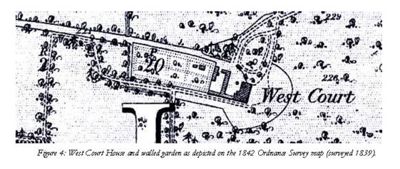
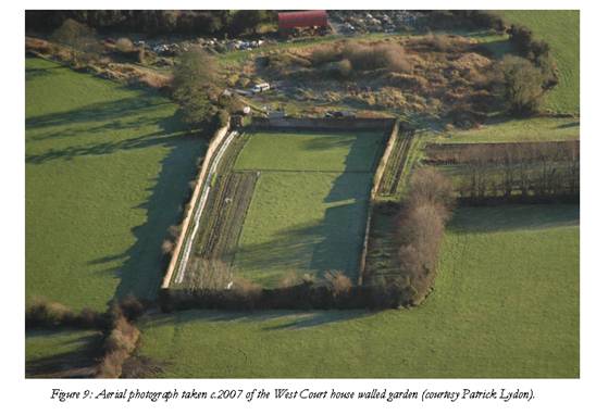
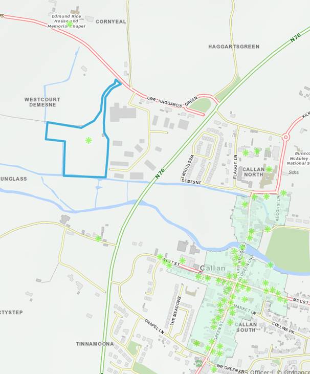
Callan’s archaeological heritage is protected under the National Monuments Acts (1930-2004), Natural Cultural Institutions Act 1997 and the Planning Acts. The Record of Monuments and Places (RMP) is an inventory, established under Section 12 of the National Monuments (Amendment) Act 1994, of sites and areas of archaeological significance, numbered and mapped. The RMP includes all known monuments and sites of archaeological importance dating to before 1700 AD, and some sites which date from after 1700 AD. There is a Recorded Monument within the amended area, ref. KK026-002 ‘Castle’ located in Westcourt Demesne (shown in figure 4.10 below) and Callan town is a zone of archaeological potential.
According to Colín O Drisceoil’s report[8], c.1940 there was a catastrophic fire at West Court house and the house was abandoned and later knocked. The rubble heap to the west of the walled garden marks the location of the house. Its foundations, perhaps cellars, and related structures probably survive below ground level.
4.8.3 Architectural Heritage
4.8.3.1 Introduction
The term architectural heritage is defined in the Architectural Heritage (National Inventory) and Historic Monuments Act 1999 as meaning all: structures and buildings together with their settings and attendant grounds, fixtures and fittings; groups of structures and buildings; and, sites which are of technical, historical, archaeological, artistic, cultural, scientific, social, or technical interest.
4.8.3.2 Record of Protected Structures
The Record of Protected Structures (RPS) included in the County Development Plan is legislated for under the Planning and Development Act 2000 as amended. There is one Protected Structure within the Amendment area. This is the ‘Ruin of a seven bay, two storey house, c18th’. The photograph below illustrate that there is no above ground structure visible on the site, with the exception of the walled garden (foreground). The walled garden of West Court house measures 111m x 42m and was situated to the west of the house complex.
Current entries to the RPS for the surrounding area are mapped on Figure 4.7. There are no entries to the National Inventory of Architectural Heritage (NIAH) in the Amendment area.
4.8.3.3 Architectural Conservation Area
An Architectural Conservation Area (ACA) is a place, area, group of structures or townscape, which is of special architectural, historical, archaeological, artistic, cultural, scientific, social or technical interest or contributes to the appreciation of a Protected Structure. In an ACA, protection is placed on the external appearance of such areas or structures. Planning permission must be obtained before significant works can be carried out to the exterior of a structure in an ACA, which might alter the character of the structure, or of the ACA.
The Callan ACA is mapped on Figure 4.7. The area to which the Amendment refers is located outside of the ACA.
4.8.4 Existing Problems
The context of archaeological and architectural heritage has changed over time within the Plan area however no existing conflicts with legislative objectives governing archaeological and architectural heritage have been identified.
Figure 4.6 Archaeological Heritage - Entries to the Record of Monuments and Places and Zone of Archaeological Importance
Source: Kilkenny County Council (2015)
Figure 4.7 Architectural Heritage - Entries to the Record of Protected Structures and Architectural Conservation Area
Source: Kilkenny County Council (2015)
4.9 Landscape
4.9.1 Introduction
Landscapes are areas which are perceived by people and are made up of a number of layers: landform, which results from geological and geomorphological history; land cover, which includes vegetation, water, human settlements, and; human values which are a result of historical, cultural, religious and other understandings and interactions with landform and landcover.
4.9.2 Legislation
The importance of landscape and visual amenity and the role of its protection are recognised in the Planning and Development Act 2000 as amended, which requires that Plans include objectives for the preservation of the landscape, views and the amenities of places and features of natural beauty.
4.9.3 Landscape Character Assessment
4.9.3.1 Overview
A Landscape Character Assessment (LCA) is a study of a given landscape to determine its ‘character’. Landscape character is the combination of physical, as well as, perceived aspects of the landscape.
The Kilkenny LCA was produced as part of the Kilkenny County Development Plan 2014-2020 -2014 and has subsequently been incorporated into the 2014-2020 County Plan. The LCA divides the County into Landscape Character Areas i.e. unique, geographically-specific areas of a particular landscape type.
The aim of the County Kilkenny LCA is to provide a tool for decision making regarding development control and to influence landscape policy at local level. In considering landscape character in the area, the Council acknowledges the importance of taking into account adjoining landscape character, landscape features and designations, including those in adjoining counties.
The town of Callan is located in a ‘Lowland’, classified as the ‘Kilkenny Western Basin’ area as set out in Figure 8.2 of the County Development Plan.
4.9.4 Views and Prospects
It is the policy of the Council to protect scenic views and routes within the County. Those proposing development on lands affected by the protected views will be required to demonstrate that the development proposals will allow for the public appreciation of the protected views as well as ensuring protection of the setting and context of the monument, how it would have sat within the wider landscape and having regard to the place as well as the monument. Where appropriate, photomontages will be required.
The nearest protected views, as per the County Development Plan, to the subject site are shown on the following map.
Map 4.17: Protected Views and Proposed Amendment
4.9.5 Existing Environmental Problems
Developments have resulted in changes to the visual appearance of the landscape within the Plan area however legislative objectives governing landscape and visual appearance were not identified as being conflicted with.
4.10 Overlay of Sensitivities
In order to illustrate the sensitivities described above,
Figure 4.8 is a composite overlay of heritage sensitivities for the Amendment area. This illustrates that there is a Recorded Monument and Protected Structure within the Amendment area, and that the River Barrow River Nore SAC, a Natura 2000 site, is located immediately to the south.
The occurrence of multiple sensitivities in any location does not preclude development; rather it flags at a strategic level that the mitigation measures - which have already been integrated into the special development objective as part of the proposed Amendment- will need to be complied with in order to ensure that the implementation of the Plan contributes towards environmental protection.

Figure 4.8 Composite map of Heritage Sensitivities