Strategic Flood Risk Assessment (SFRA)
|
Planning Department, Kilkenny County Council |
|
Strategic Flood Risk Assessment |
|
Proposed Amendment No. 2 of Callan Local Area Plan 2009-2020 |
|
Forward Planning |
|
January 2016 |
|
|
Contents
1.2 Structure of a Flood Risk Assessment (FRA)
2.1 Stage 1 Flood Risk Identification
2.1.1 Regional Flood Risk Appraisal
2.1.2 Strategic Flood Risk Appraisal
2.2 Stage 2 Initial Flood Risk Assessment
List of Maps
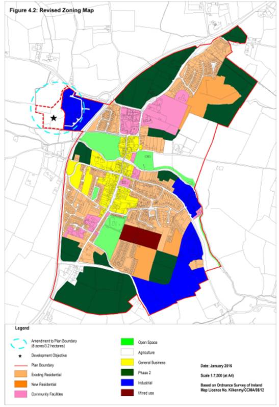
Map 1: Revised Figure 4.2 Zoning Map Callan Local Area Plan 2009-2020
Map 2: Composite Map of Flood Risks
Map 3: Flood Zones
List of Figures
Figure 1: CFRAMS Draft Mapping for Callan, 2015
Figure 2: Hyder Consulting Flood Zones for Callan, 2010
Figure 3: Historic Flood Events, OPW
Figure 4: Benefitting Lands, OPW
Figure 5: Alluvial Soils, 2006
Figure 6: Ordnance Survey 6 inch map, 1829-1842
1 Introduction
In line with The Planning System and Flood Risk Management – Guidelines for Planning Authorities, a staged approach has been taken to the appraisal and assessment of flood risk for Amendment No. 2 of the Callan Local Area Plan 2009-2020.
The proposed Amendment involves the extension of the LAP boundary to include an 8 acre site at Westcourt, Callan as per revised Figure 4.2 Zoning Map. The land will be zoned ‘Agriculture’. The ‘Agriculture’ zoning objective to be included in the Plan is as follows:
Objective: To conserve and protect agricultural land from interference from non-agricultural uses. To prevent development of agricultural land adjacent to development areas which would prejudice the future expansion of the town, except in exceptional circumstances where there are site specific development objectives for the provision of certain types of development.
Permissible uses: Agriculture, horticulture, public service installations, uses identified in site specific development objectives.
Open for Consideration: Public open space, guesthouse, restaurant, nursing home, dwelling houses in certain limited cases, halting site, private open space, other uses not contrary to the proper planning and sustainable development of the area.
It is proposed to include a site specific objective for this land as follows:
To facilitate the development of a residential complex (10 units approx.) initiated by the Camphill Community with ancillary small scale socio-economic uses related to the activities of the residents of the development, and to provide for a pedestrian link from the lands to the town centre, subject to the following:
· The development must not interfere with the ecological integrity of the adjacent Kings River which forms part of the River Barrow and River Nore SAC, a Natura 2000 site. Any future development (including pedestrian link) of the lands will be subject to Appropriate Assessment in accordance with Article 6 of the Habitats Directive.
· A site-specific Flood Risk Assessment appropriate to the type and scale of the proposed development and a site specific justification test if required must be submitted at planning application stage in line with the DoEHLG Guidelines “The Planning System and Flood Risk Management”, November 2009.
· Any developments proposed for the lands at Westcourt must be connected to the foul sewer network for treatment of waste water. Such developments will only proceed subject to the local treatment plant having capacity to adequately treat the additional load. It must be shown by proposals that all storm water can be appropriately collected, stored and treated so as not to affect the quality of water bodies.
· The archaeological importance of the site must be safeguarded by protecting archaeological sites and monuments (including their setting), and archaeological objects, including those that are listed in the Record of Monuments and Places, and in the Urban Archaeological Survey of County Kilkenny or newly discovered sub‐surface archaeological remains. Any proposed development in the vicinity or confines of archaeological monuments will require an archaeological assessment and the preparation of an archaeological impact statement for submission as part of any planning application for development within this area.
· When innovative layouts and exceptional design for living are achieved, strict adherence to the development management standards for new residential developments as set out in Chapter 12 of the County Development Plan 2014-2020 will not be required, provided the proposed designs can be demonstrated to satisfy the social and physical needs of the occupants.
1.1 Disclaimer
It is important to note that compliance with the requirements of The Planning System and Flood Risk Management - Guidelines for Planning Authorities, and of the Floods Directive 2007 60/EC is a work in progress and is currently based on emerging and incomplete data as well as estimates of the locations and likelihood of flooding. In particular, the assessment and mapping of areas of flood risk awaits the adoption of the finalised Catchment-based Flood Risk Assessment and Management Plans [CFRAMs]. As a result, this Flood Risk Assessment is based on available information.
Accordingly, all information in relation to flood risk is provided for general policy guidance only. It may be substantially altered in light of future data and analysis. As a result, all landowners and developers are advised that Kilkenny County Council and its agents can accept no responsibility for losses or damages arising due to assessments of the vulnerability to flooding of lands, uses and developments. Owners, users and developers are advised to take all reasonable measures to assess the vulnerability to flooding of lands in which they have an interest prior to making planning or development decisions.
1.2 Structure of a Flood Risk Assessment (FRA)
The Guidelines recommend that a staged approach is adopted when undertaking a Flood Risk Assessment (FRA). The recommended stages are briefly described below:
• Stage 1 ~ Flood Risk Identification
To identify whether there may be any flooding or surface water management issues that may require further investigation. This stage mainly comprises a comprehensive desk study of available information to establish whether a flood risk issue exists or whether one may exist in the future. This stage also includes collation of relevant local information.
• Stage 2 ~ Initial Flood Risk Assessment
If a flood risk issue is deemed to exist arising from the Stage 1 Flood Risk Identification process, the assessment proceeds to Stage 2 which confirms the sources of flooding, appraises the adequacy of existing information and determines what surveys and modelling approach is appropriate. The extent of the risk of flooding should be assessed which may involve preparing indicative flood zone maps. The initial assessment may determine that sufficient quantitative information is available, appropriate to the scale and nature of the changed land use or development proposed for the necessary decision to be made.
• Stage 3 ~ Detailed Flood Risk Assessment
This is carried out to assess flood risk issues in sufficient detail and to provide a quantitative appraisal of potential flood risk to a proposed or existing development or land to be zoned, of its potential impact on flood risk elsewhere and of the effectiveness of any proposed mitigation measures.
Map 1: Revised Figure 4.2 Zoning Map Callan LAP
1.3 The Sequential Approach
The sequential approach in terms of flood risk management is based on the following principles: AVOID - SUBSTITUTE - JUSTIFY - MITIGATE – PROCEED.
The primary objective of the sequential approach is that development is primarily directed towards land that is at low risk of flooding (AVOID). The next stage is to ensure that the type of development proposed is not especially vulnerable to the adverse impacts of flooding (SUBSTITUTION).
The Justification Test is designed to rigorously assess the appropriateness, or otherwise, of particular developments that, for various reasons, are being considered in areas of moderate or high flood risk (JUSTIFICATION). The test is comprised of two processes, namely the Plan-Making Justification Test and the Development Management Justification Test. Only the former (Plan-Making Justification Test) is relevant to a Strategic Flood Risk Assessment for a Plan, and this is described as follows.
Justification Test for Development Plans (See p.37 of the Guidelines)
“Where, as part of the preparation and adoption or variation and amendment of a development/local area plan, a planning authority is considering the future development of areas in an urban settlement that are at moderate or high risk of flooding, for uses or development vulnerable to flooding that would generally be inappropriate as set out in Table 3.2 of the Guidelines, all of the following criteria must be satisfied:
1) The urban settlement is targeted for growth under the National Spatial Strategy, regional planning guidelines, statutory plans as defined above or under the Planning Guidelines or Planning Directives provisions of the Planning and Development Act 2000, as amended.
2) The zoning or designation of the lands for the particular use or development type is required to achieve the proper and sustainable planning of the urban settlement and in particular:
i. Is essential to facilitate regeneration and/or expansion of the centre of the urban settlement
ii. Comprises significant previously developed and/or under-utilised lands;
iii. Is within or adjoining the core of an established or designated urban settlement;
iv. Will be essential in achieving compact or sustainable urban growth;
v. There are no suitable alternative lands for the particular use or development type, in areas at lower risk of flooding within or adjoining the core of the urban settlement (This criterion may be set aside where section 4.27b applies- ‘Existing undeveloped zoned areas at risk of flooding’).
3) A flood risk assessment to an appropriate level of detail has been carried out as part of the Strategic Environmental Assessment as part of the development plan preparation process, which demonstrates that flood risk to the development can be adequately managed and the use or development of the lands will not cause unacceptable adverse impacts elsewhere.
N.B. The acceptability or otherwise of levels of any residual risk should be made with consideration for the proposed development and the local context and should be described in the relevant flood risk assessment.”
MITIGATION is the process where the flood risk is reduced to acceptable levels by means of land use strategies or by means of detailed proposals for the management of flood risk and surface water, all as addressed in the Flood Risk Assessment. The decision to PROCEED should only be taken after the Justification Test has been passed.
2 Flood Risk Assessment
2.1 Stage 1 Flood Risk Identification
The purpose of this stage is to identify whether there are any flooding or surface water management issues relating to the proposed amendment plan area that may warrant further investigation. Sources which were consulted are outlined below. This assessment is for an amendment to a Local Area Plan and therefore is at the Strategic Flood Risk Assessment scale.
2.1.1 Regional Flood Risk Appraisal
A Regional FRA was carried out and published as Appendix 3 to the Strategic Environmental Assessment of the South East Regional Planning Guidelines, 2010. This document provided guidance on the issues to be addressed in any Strategic Flood Risk Assessment. The Regional FRA referred to flooding that occurred in August 2008 and stated that “Graiguenamanagh and Callan, two of the worst-hit parts of the county, along with Thomastown will benefit from a Flood Risk Management Study which will be undertaken by Kilkenny County Council” (See Section 2.4 below).
2.1.2 Strategic Flood Risk Appraisal
A Strategic Flood Risk Assessment for the County was published in 2014 as part of the County Development Plan 2014-2020. This examined the level of information available on flooding in the county. This did not specifically address the Callan LAP area.
A Flood Risk Assessment of Amendment 1 to the Callan Local Area Plan (Core Strategy) was carried out in March 2012.
2.1.3 CFRAM Programme
CFRAM is Catchment Flood Risk Assessment and Management. The national CFRAM programme commenced in Ireland in 2011. The OPW is the lead agency for flood risk management in Ireland and is the national competent authority for the EU Floods Directive. The CFRAM Programme comprises three phases:
- The Preliminary Flood Risk Assessment (PFRA): 2011
- The CFRAM Studies and parallel activities: 2011-2015
- Implementation and Review: 2016 onwards
The ‘Floods’ Directive[1] requires Member States to undertake a national preliminary flood risk assessment by 2011 to identify areas where significant flood risk exists or might be considered likely to occur. In March 2012, the OPW published the National Preliminary Flood Risk Assessment, Overview Report. The objective of the PFRA is to identify Areas for Further Assessment (AFA’s) and this further assessment will take place though Catchment Flood Risk Assessment and Management Studies (CFRAMS). Callan was identified as a ‘Possible Area for Further Assessment’. A Draft CFRAM flood map for the Callan area was published by the OPW in November 2015 and this is discussed below.
2.1.4 Available sources
The data listed below is available and provides information on the historical occurrence of flooding as it relates to the proposed amendment.
Primary Sources for flood risk information:
(i) CFRAM floodmaps / models
A draft flood hazard map for Callan was published on behalf of the OPW for public consultation purposes in 2015. This shows that the subject site is affected by the 1% and 0.1% AEP event risk. An extract is reproduced below (It should be noted that this is a draft map published for consultation purposes only):
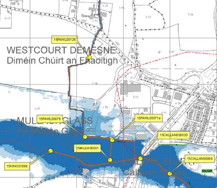
Figure 1: CFRAMS Draft Mapping for Callan, 2015.
(ii) Detailed flood study
Kilkenny County Council commissioned Hyder Consulting to carry out a Flood Relief Report for Callan, Thomastown and Graiguenamanagh in 2010. The Callan Report included detail on historical flood events and mapped the 100 year flood extent around the River Nore (see extract from the map below). This report recommended two measures for mitigation of flood risk in Callan:
· Flood Cell 1 (the left bank) - Flood defence wall around the car park at KCAT
· Flood Cell 2 (the right bank) Flood proofing and awareness
These measures were incorporated into the flood alleviation scheme which was completed in Callan in 2011. This scheme is to address flooding in the central core of the town around Bridge Street/KCAT car park/Clotheen Lane area. Its focus is the protection of residences and businesses. It has done this by a combination of earthen bunds, structural walls, flood gates and flap valves on existing outflows.
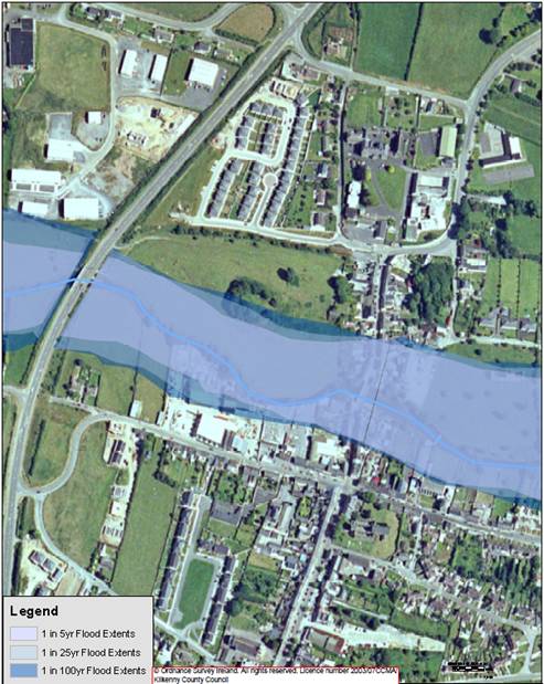
Figure 2: Hyder Consulting Flood Zones for Callan, 2010
Secondary Sources
i) Office of Public Works OPW Flood Events Mapping
As part of the National Flood Risk Management Policy, the OPW developed the www.floodmaps.ie web based data set, which contains information concerning historical flood data, displays related mapped information and provides tools to search for and display information about selected flood events. Two flood events are noted proximate to the site, as shown below, (i) Approx. 170m south of the subject site a flood event occurred in October 2004, and (ii) approx. 130m to the south east of the subject lands a flood event occurred in October 2004 also. No flood events are shown on the subject site.
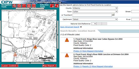
Figure 3: Historic Flood Events, www.flooding.ie
ii) OPW Benefitting Lands mapping
These maps were prepared to identify areas that would benefit from land drainage schemes, and typically indicate low-lying land near rivers and streams that might be expected to be prone to flooding. The extract below shows the south-western part of the proposed amendments area to be benefitting lands (indicated in red hatching).
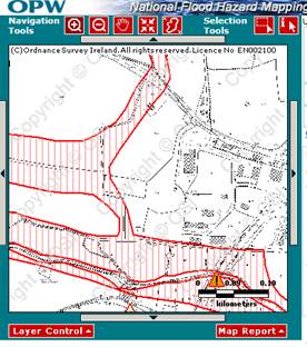
Figure 4: Benefitting Lands, www.flooding.ie
iii) Mineral Alluvial Soil Mapping
The soils and subsoils maps were created by the Spatial Analysis Unit, Teagasc. The project was completed in May 2006 and was a collaboration between Teagasc, Geological Survey of Ireland, Forest Service and the EPA. The presence of alluvial soils can indicate areas that have flooded in the past (the source of the alluvium). The map below shows the location of alluvial soils immediately south of the Amendment area and to the north (none on the subject site).
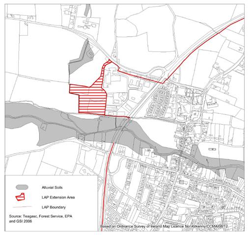
Figure 5: Alluvial Soils, 2006
iv) Ordnance Survey “Lands liable to floods” mapping (6” OS maps)
These maps have been studied to see if there is an area marked as being “Liable to Floods” in or in the vicinity of the zoned areas. It is noted that the OS maps simply show the text “Liable to Floods” without delineating the extent of these areas. An extract from the 6’’ map is attached overleaf. No text is shown in relation to the proposed amendment site.
It should be noted that some of this data is historically derived, not prescriptive in relation to flood return periods and not yet predictive or inclusive for climate change analysis. Many of these maps were based on survey work carried out from 1833-1844 with many updated in the 1930s and 1940s. Therefore they do not show or take account of recent changes in surface drainage, such as development in floodplains, road realignments or drainage works for forestry or agriculture. So there is significant potential that flood risk in some areas may have increased or been reduced since they were prepared.
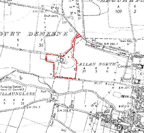
Figure 6: Ordnance Survey 6 inch map, 1829-1842
2.1.5 Conclusion of Stage 1
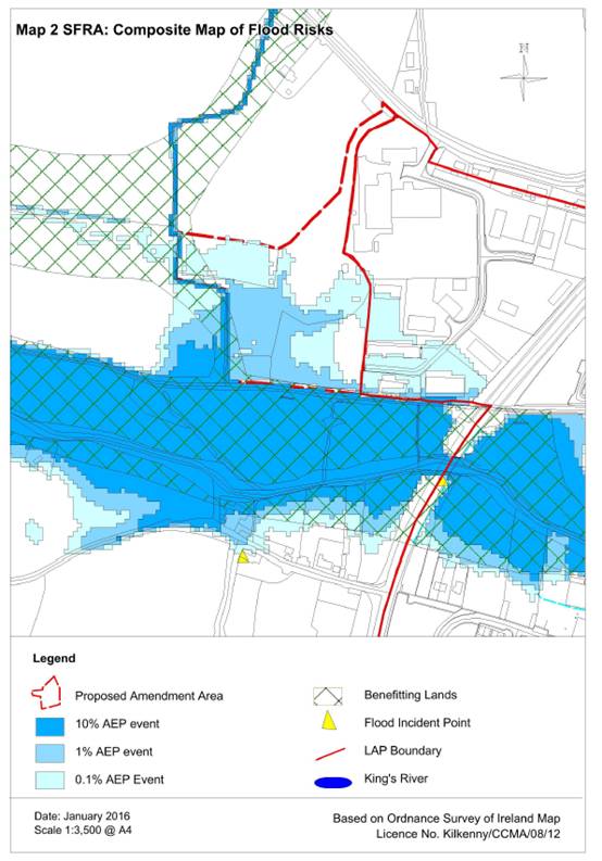
The available sources of information is summarised in table 1 below and a composite map of the flood risks in relation to the proposed amendment area is shown in Map 2.
Having regard to all of the information sources as outlined above, it is considered that the area could be subject to a potential flood risk issue and therefore the assessment should proceed to Stage 2.
2.2 Stage 2 Initial Flood Risk Assessment
The purpose of this stage is to ensure that all relevant flood risk issues are assessed in relation to the decisions to be made, and potential conflicts between flood risk and development are addressed to the appropriate level of detail. The extent of the risk of flooding should be assessed which may involve preparing indicative flood zone maps. Having identified flood zones, the sequential approach is used to direct, where possible, new development to areas at low risk of flooding.
2.2.1 Flood zone mapping
Flood zones are geographical areas within which the likelihood of flooding is in a particular range. There are three types of flood zones defined:
- Flood zone A – where the probability of flooding from rivers and the sea is highest (greater than 1% or 1 in 100 for river flooding)
- Flood Zone B – where the probability of flooding from rivers and the sea is moderate (greater than 0.1% or 1 in 1000 for river flooding)
- Flood Zone C – where the probability of flooding from rivers and the sea is low (less than 0.1% or 1 in 1000 for river flooding). Flood Zone C covers all areas of the plan which are not in zones A or B.
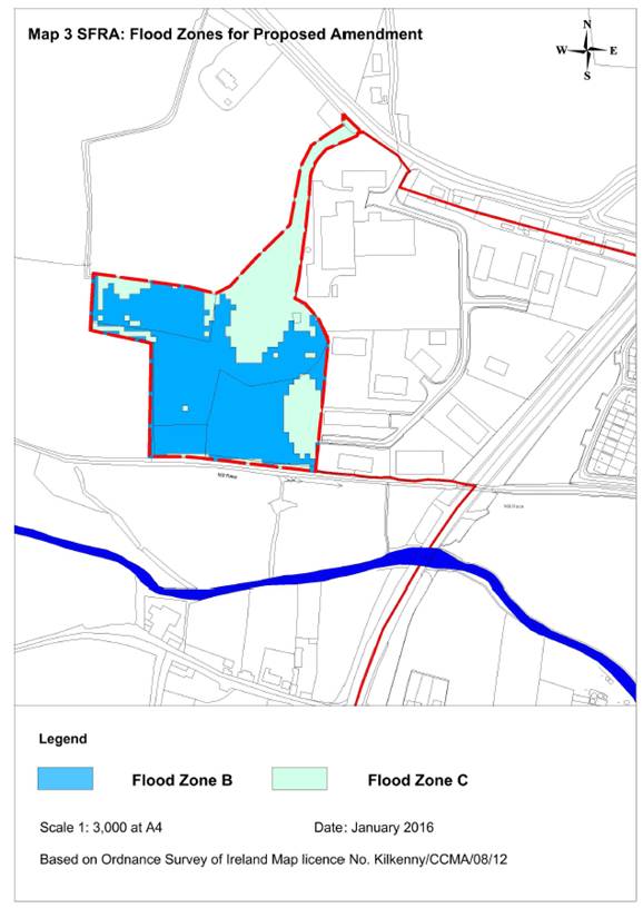
The Draft CFRAMS mapping produced for the King’s River is the most recent and reliable data in terms of flooding for the subject site. For this reason, it is used in determining flood zones on the subject site in deference to other sources.
Accordingly, it is considered that the south-western part of the subject site is located in Flood Zone B and the remainder of the site is located in Flood Zone C. This is illustrated in Map 3 overleaf.
2.2.2 Application of the Sequential Approach
Having identified the flood risk zones within the plan area the next step is to apply the sequential approach to land use planning. The Guidelines have categorised land uses into three vulnerability classes and have also specified which vulnerability class would be appropriate in each flood zone, or where the Justification Test would be required.
The table of vulnerability classes (Table 3.1 of the Guidelines) is as follows:
|
Table 1 Classification of vulnerability of different types of development |
|
|
Vulnerability Class |
Land uses and types of development which include*: |
|
Highly vulnerable development (including essential infrastructure) |
Garda, ambulance and fire stations and command centres required to be operational during flooding; Hospitals; Emergency access and egress points; Schools; |
|
Dwelling houses, student halls of residence and hostels; |
|
|
Residential institutions such as residential care homes, children’s homes and social services homes; |
|
|
Caravans and mobile home parks; |
|
|
Dwelling houses designed, constructed or adapted for the elderly or, other people with impaired mobility; and |
|
|
Essential infrastructure, such as primary transport and utilities distribution, including electricity generating power stations and sub-stations, water and sewage treatment, and potential significant sources of pollution (SEVESO sites, IPPC sites, etc.) in the event of flooding. |
|
|
Less vulnerable development |
Buildings used for: retail, leisure, warehousing, commercial, industrial and non-residential institutions; Land and buildings used for holiday or short-let caravans and camping, subject to specific warning and evacuation plans; |
|
Land and buildings used for agriculture and forestry; |
|
|
Waste treatment (except landfill and hazardous waste); |
|
|
Mineral working and processing; and |
|
|
Local transport infrastructure. |
|
|
Water-compatible development |
Flood control infrastructure; Docks, marinas and wharves; Navigation facilities; |
|
Ship building, repairing and dismantling, dockside fish processing and refrigeration and compatible activities requiring a waterside location; |
|
|
Water-based recreation and tourism (excluding sleeping accommodation); |
|
|
Lifeguard and coastguard stations; |
|
|
Amenity open space, outdoor sports and recreation and essential facilities such as changing rooms; and |
|
|
Essential ancillary sleeping or residential accommodation for staff required by uses in this category (subject to a specific warning and evacuation plan). |
|
|
*Uses not listed here should be considered on their own merits |
|
Table 3.2 of the Guidelines sets out how the vulnerability classes interact with the flood zones and when the Justification Test is required.
|
Development |
Flood Zone A |
Flood Zone B |
Flood Zone C |
|
Highly vulnerable |
Justification Test |
Justification Test |
Appropriate |
|
Less vulnerable |
Justification Test |
Appropriate |
Appropriate |
|
Water-compatible |
Appropriate |
Appropriate |
Appropriate |
The Amendment to the LAP is to zone the land ‘Agriculture’ and include a site specific development objective for the land.
Agricultural use is listed as a ‘less vulnerable’ class of use in Table 3.1 of the Guidelines. Therefore, the Agricultural zoning is appropriate for Flood Zones B and C, and a justification test is not required in this instance.
A residential based complex/development for the Camphill Community is considered to be a ‘highly vulnerable’ class of use as defined in Table 3.1 of the Guidelines. In accordance with Table 3.2 of the Guidelines, this type of use is appropriate in Flood Zone C and a justification test is required for this use in Flood Zone B.
While a site-specific Flood Risk Assessment and a site specific justification test is required to be submitted at planning application stage, it is considered prudent to carry out a justification test for this type of development as part of the strategic flood risk assessment in accordance with Section 3.8 of the Guidelines.
2.2.3 Justification Test
This justification test refers to a residential use for the Camphill Community as it pertains to the Flood Zone B part of the amendment site.
The criteria for the Justification Test are outlined in Section 1.3.1 of the Guidelines and the test is set out below.
1. The urban settlement is targeted for growth under the National Spatial Strategy, regional planning guidelines, statutory plans or under the Planning Guidelines or Planning Directives provisions of the Planning and Development Act 2000, as amended.
Callan is identified as a District Town in the Regional Planning Guidelines 2010-2022. District towns are “targeted for growth as centres that can perform an important role in driving the development of a particular spatial component of the overall region”. Callan is also a District Town in the County Development Plan spatial hierarchy.
2. The zoning or designation of the lands for the particular use or development type is required to achieve the proper and sustainable planning of the urban settlement and in particular:
a. Is essential to facilitate regeneration and/or expansion of the centre of the urban settlement
b. Comprises significant previously developed and/or under-utilised lands;
c. Is within or adjoining the core of an established or designated urban settlement;
d. Will be essential in achieving compact or sustainable urban growth;
e. There are no suitable alternative lands for the particular use or development type, in areas at lower risk of flooding within or adjoining the core of the urban settlement.
The site is immediately adjacent to the town boundary of the Callan LAP. The Camphill Community currently owns the subject site and it is economically feasible and viable for these lands to be developed for these purposes. The pedestrian connection from the site back to the core of the town will consolidate the Camphill community and help it grow sustainably within the town. However, the development of the Zone B part of the site is not essential in achieving compact urban growth and there are alternative zoned lands available in Callan that could be developed for this purpose. Therefore, it is considered that the development objective as it relates to Zone B does not satisfy this part of the justification test.
3. A flood risk assessment to an appropriate level of detail has been carried out as part of the Strategic Environmental Assessment as part of the development plan preparation process, which demonstrates that flood risk to the development can be adequately managed and the use or development of the lands will not cause unacceptable adverse impacts elsewhere.
A Flood Risk Assessment was carried out for Amendment No. 1 of the Callan LAP in 2010 for the Core Strategy. Flood management policies were included in that Amendment to mitigate unacceptable impacts from flooding.
The County Development Plan 2014-2020, for which a full SEA and SFRA were carried out, also contains policies in relation to flooding and mitigation of flooding which is relevant to Callan. A full suite of Development Management Standards in relation to surface water drainage is set out in Section 9.2.11 of the County Development Plan which is applicable to new developments in Callan also.
The SEA and SFRA carried out for Amendment No. 1 of the LAP and the County Development Plan 2014-2020 have informed policy in relation to flooding. These policies demonstrate that flood risk can be adequately managed and unacceptable adverse impacts elsewhere can be prevented.
Justification Test Conclusion:
The development objective as it relates to Zone B does not satisfy part 2 of the justification test as prescribed in Section 4.23 of the Guidelines and accordingly a residential use in flood zone B should be excluded from the Amendment.
2.2.4 Stage 2 Conclusion
Having regard to the following:
(i) The ‘Agriculture’ zoning objective proposed,
(ii) The mapped flood zones,
(iii) The wording of the proposed development objective which requires a site specific flood risk assessment and justification test to be carried out for any development on the site, and
(iv) The justification test regarding the site specific objective and the Flood Zone B part of the Amendment area
It is considered that, subject to residential use being excluded from the flood zone B part of the site, the flood risk to the development of this land can be adequately managed without causing unacceptable adverse impacts elsewhere and it is not necessary at this stage to proceed to Stage 3, Detailed Flood Risk Assessment.
3 Recommendations
The following measures are recommended to further mitigate flood risk:
· Residential use shall be excluded from Flood Zone B.
· The site specific Flood Risk Assessment for any development on these lands should be carried out in accordance with Appendix A of the Guidelines. The site specific FRA may result in the boundary of the flood zones being amended.
· Flood risk management should be addressed in the design of any development on these lands, in accordance with Appendix B of the Guidelines.
· The management of surface water on the site shall accord with the policies and objectives of the current Kilkenny County Development Plan 2014-2020 and the Local Area plan 2009-2020. Details of the management of surface water on the site shall be provided at planning application stage.
This SFRA is based on currently available data and in accordance with its status as a “living document” it will be subject to modification by these emerging datasets of maps and plans as they become available. In the interim any development proposal on the subject site will be subject to a site specific Flood Risk Assessment.
[1] Directive 2007/ 60/ EC of the European Parliament and of the Council of 23rd October 2007 on the assessment and management of flood risk: Official Journal L288/ 27-34.