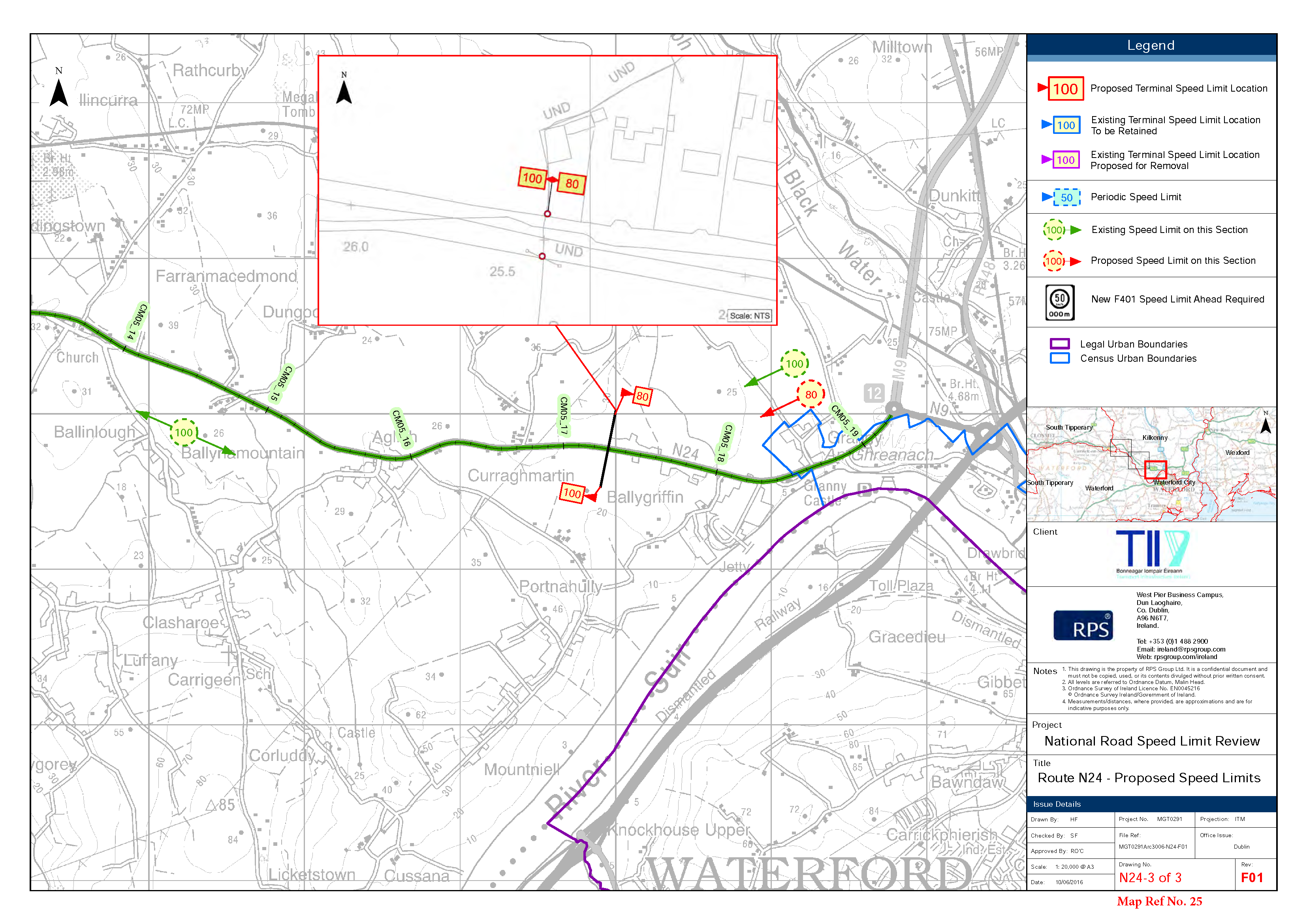
It is my understanding that the Kilkenny County Council plan to reduce the speed limit on the road from the Quarry Roundabout at Grannagh to the LAst house at Ballygriffin, from 100kmh to 80 kmh...
Sixth Schedule 80km/h
Dúnta10 Lún, 2016, 12:00pm - 9 M.F., 2016, 6:00pm
Roads in respect of which a special speed limit of 80km/hr is prescribed
The Waterford to Limerick Road (N24) from a point 590m east from its junction with the Holy Well Road (LS-7434) to a point 390m north-east of its junction with the Granny Road (LP-4221).
- The following roads at Ballyragget: (Map Ref No 3, N77-3 of 8)
The Durrow Road (N77) from a point 10m south of its junction with the Donaghmore Road (LS-5854) to a point 240m north of its junction with the Donaghmore Road (LS-5854).
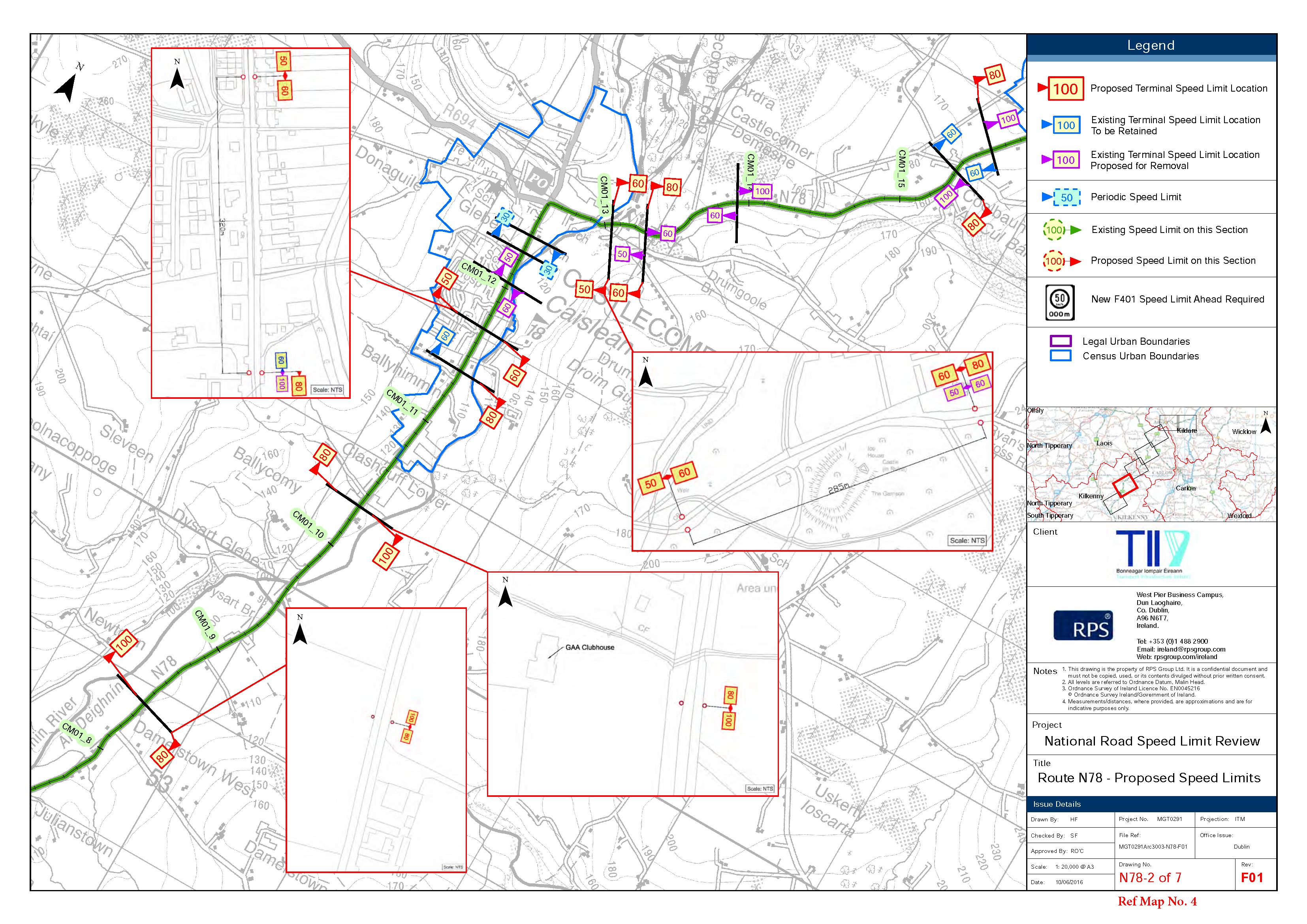
- The following roads at Castlecomer: (Map Ref No 4, N78-2 of 7)
a. The Kilkenny to Athy road (N78) from a point 550m north of its junction with the Lisnafunshin Road (LP-1823) to a point 105m south of its junction with Golf Club road (LS-5904)
b.The Kilkenny to Athy road (N78) from a point 14m north-east of its junction with Smithstown road (LP-1840) to a point 45m south-west of its junction with the Gorteen road (LS-5875).
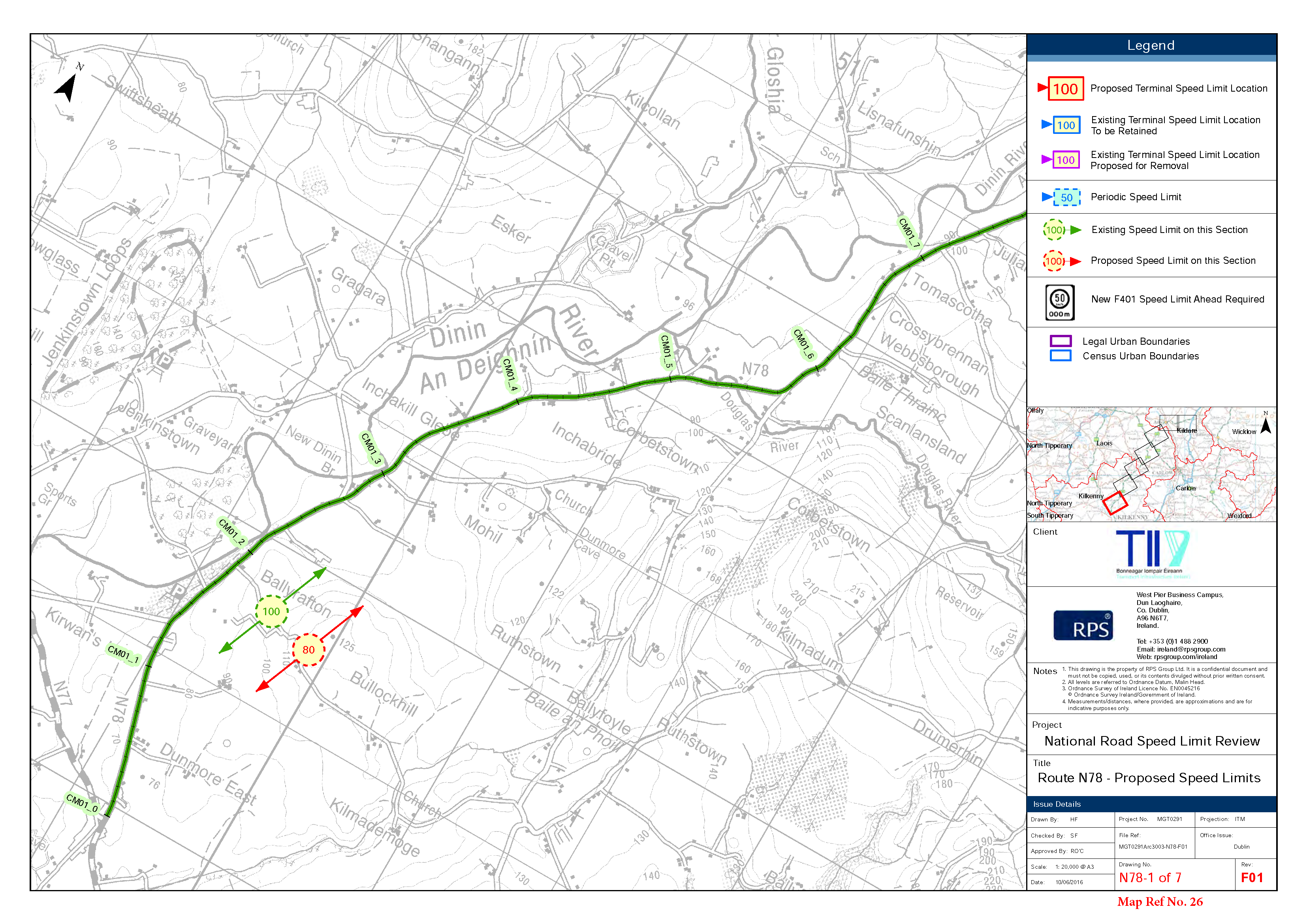
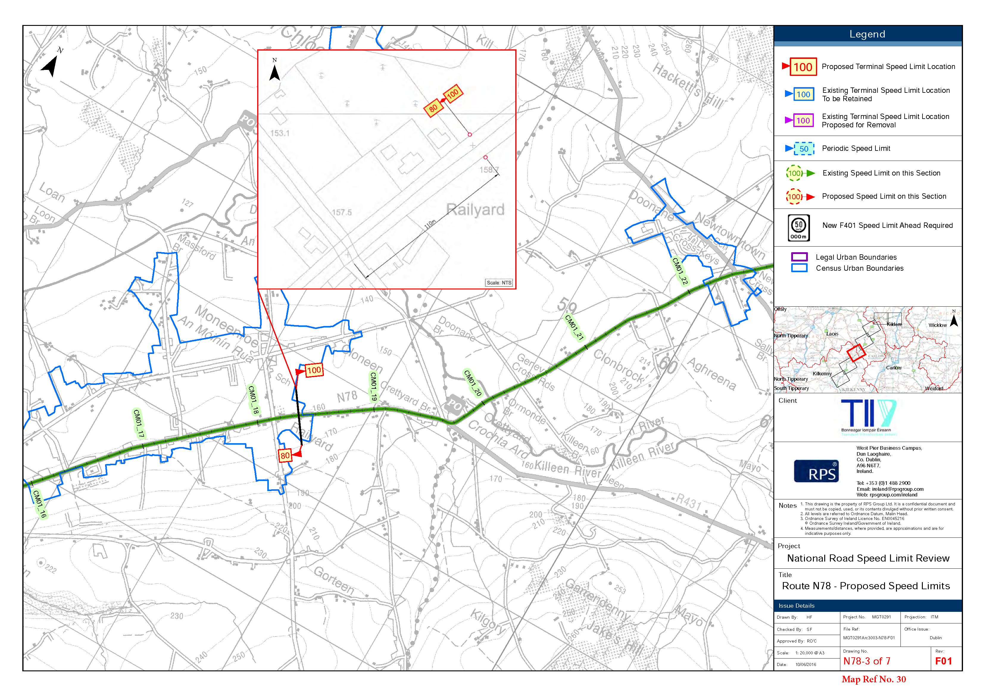
- The following roads at Corbetstown: (Map Ref No 26, N78 1 & 2 of 7)
The Kilkenny to Athy road (N78) from its junction with the Durrow road (N77) to a point 280m north of the Clogharinka road (LP-1844).
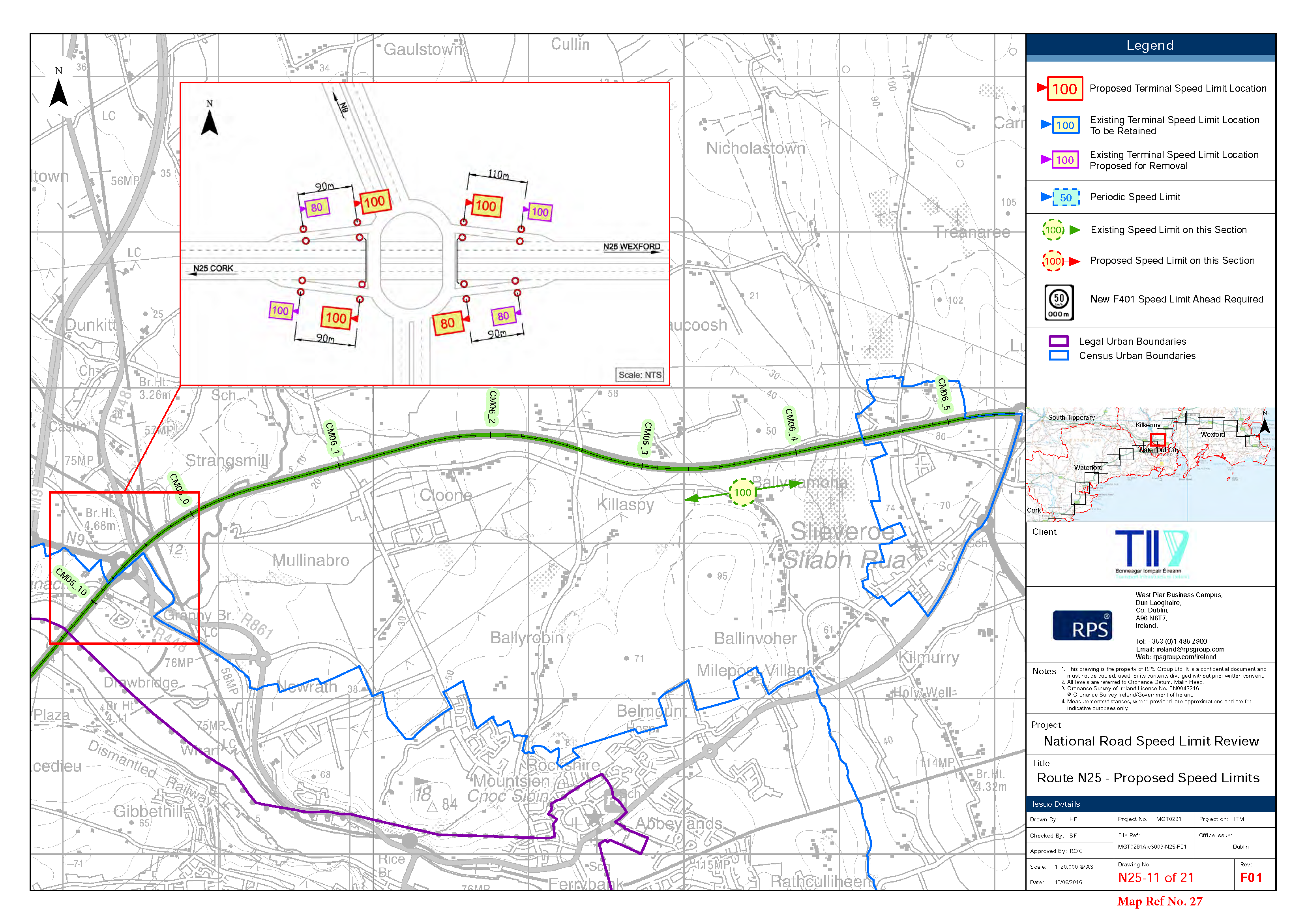
- The following roads at Grannagh: (Map Ref No 27 N25-11 of 21)
- The N25 Westbound off-ramp at Junction W1 (Grannagh Interchange) 15m north-east from the intersection of the off-ramp with the roundabout.
- The N25 Westbound on-ramp at Junction W1 (Grannagh Interchange) 15m south-west from the intersection of the on-ramp with the roundabout.
- The N25 Eastbound off-ramp at Junction W1 (Grannagh Interchange) 15m south-west from the intersection of the off-ramp with the roundabout.
- The N25 Eastbound on-ramp at Junction W1 (Grannagh Interchange) 15m north-east from the intersection of the on-ramp with the roundabout.
6. The following roads at Kilkenny: (Map Ref No 28 N10-2 & 3 of 3)
- The Waterford Road (N10) from a point 860m south of its junction with the Ring Road (N76) to a point 280m north of its junction with the Bamford Road (LP-2630).
- The Waterford Road (N10) from a point 30m north of its junction Western roundabout of the Danesfort Interchange to its tie in with the Ballyhale Road (R-713).
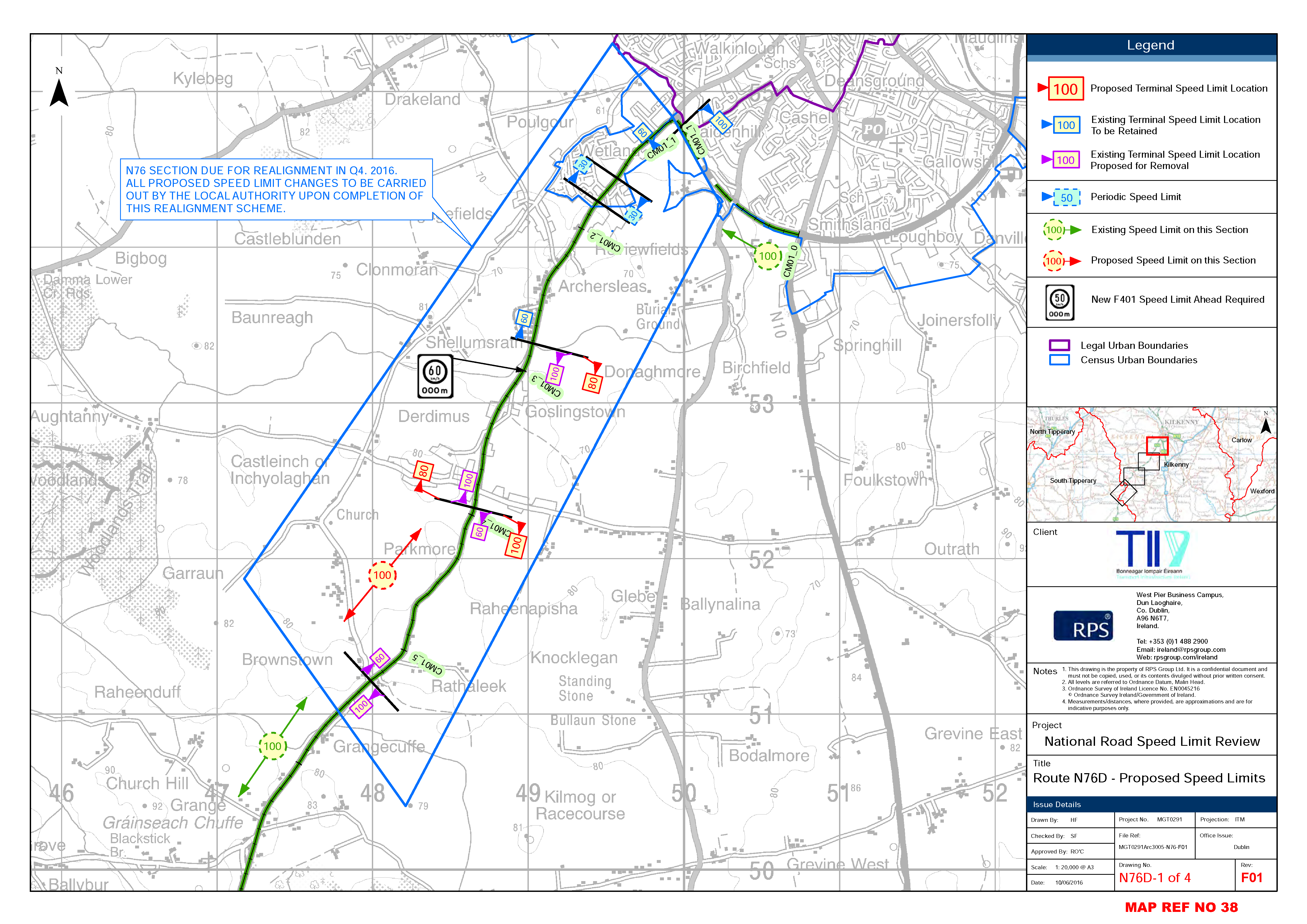
- The Kilkenny to Clonmel Road (N76) from a point 30m south of its junction with the southern entrance of the Shellumsrath Housing Estate Road (LS-6697) to a point 50m south of its junction with cross roads at Derdlmus (LP-2630). (Map reference 38 )
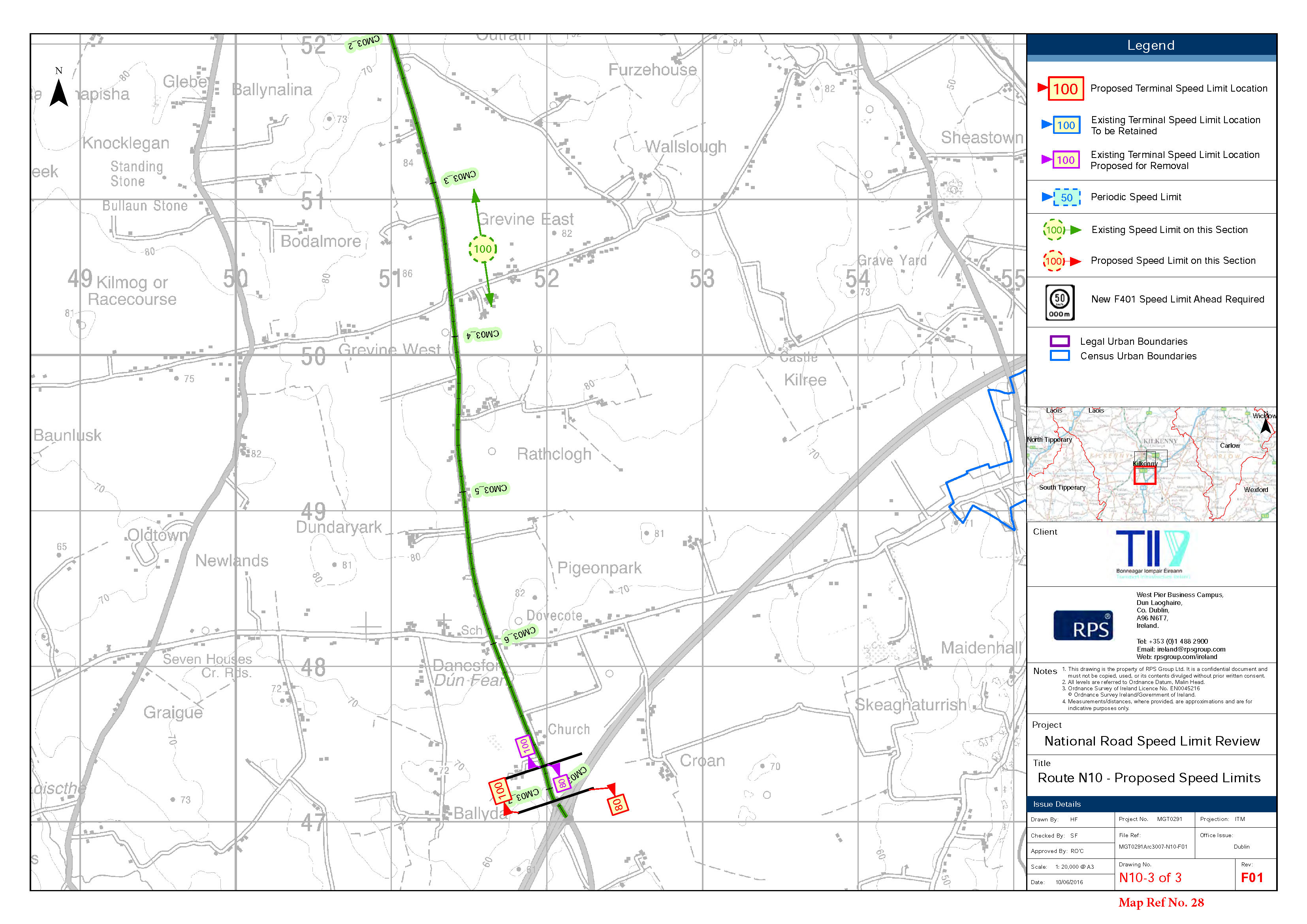
- The Durrow Road (N77) from a point 15m north of its junction with the Castlecomer Road (R-712) to a point 540m north of its junction with the Baun Road (LS-6647).
- The Durrow Road (N77) from a point 810m north of its junction with the Baun Road (LS-6647) to a point 430m north of its junction with the Connahy Road (LS-5857).
7. The following roads at Moneenroe: (Map Ref No 30, N78-2 & 3 of 7)
The Kilkenny to Athy road (N78) from a point 215m north-east of its junction with the (LS-5875) to a point 110m north-east of its junction with the (LS-5872).
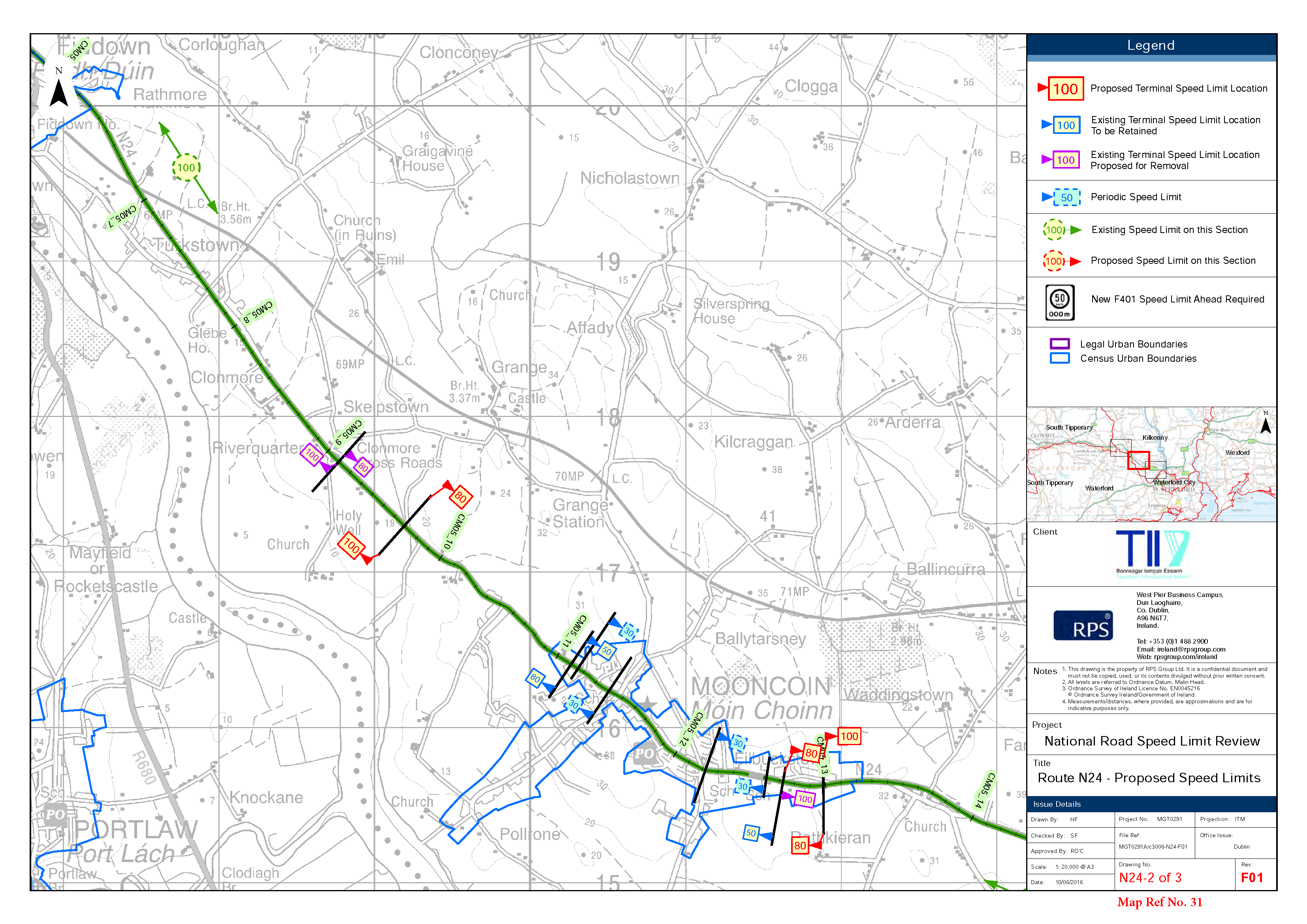
8. The following roads at Mooncoin: (Map Ref No 31 N24-2 of 3)
- The Waterford to Limerick Road (N24) from a point 10m north-west of its junction with the Grange Road (LS-7416) to a point 350m north-west of its junction with the Ballytarsney Road (LS-7419).
- The Waterford to Limerick Road (N24) from a point 550m east of its junction with the Doornane Road (LS-7417) to a point 700m west of its junction with the Rathcurby Road (LS-7431).
9. The following roads at New Ross: (Map Ref No 22, N25 14 of 21)
(a) The Waterford to New Ross Road(N25) from a point 650m east of its junction with the Forestalstown Road (LS-7512) to a point 1230m from its junction with the Forestalstown Road (LS-7512).
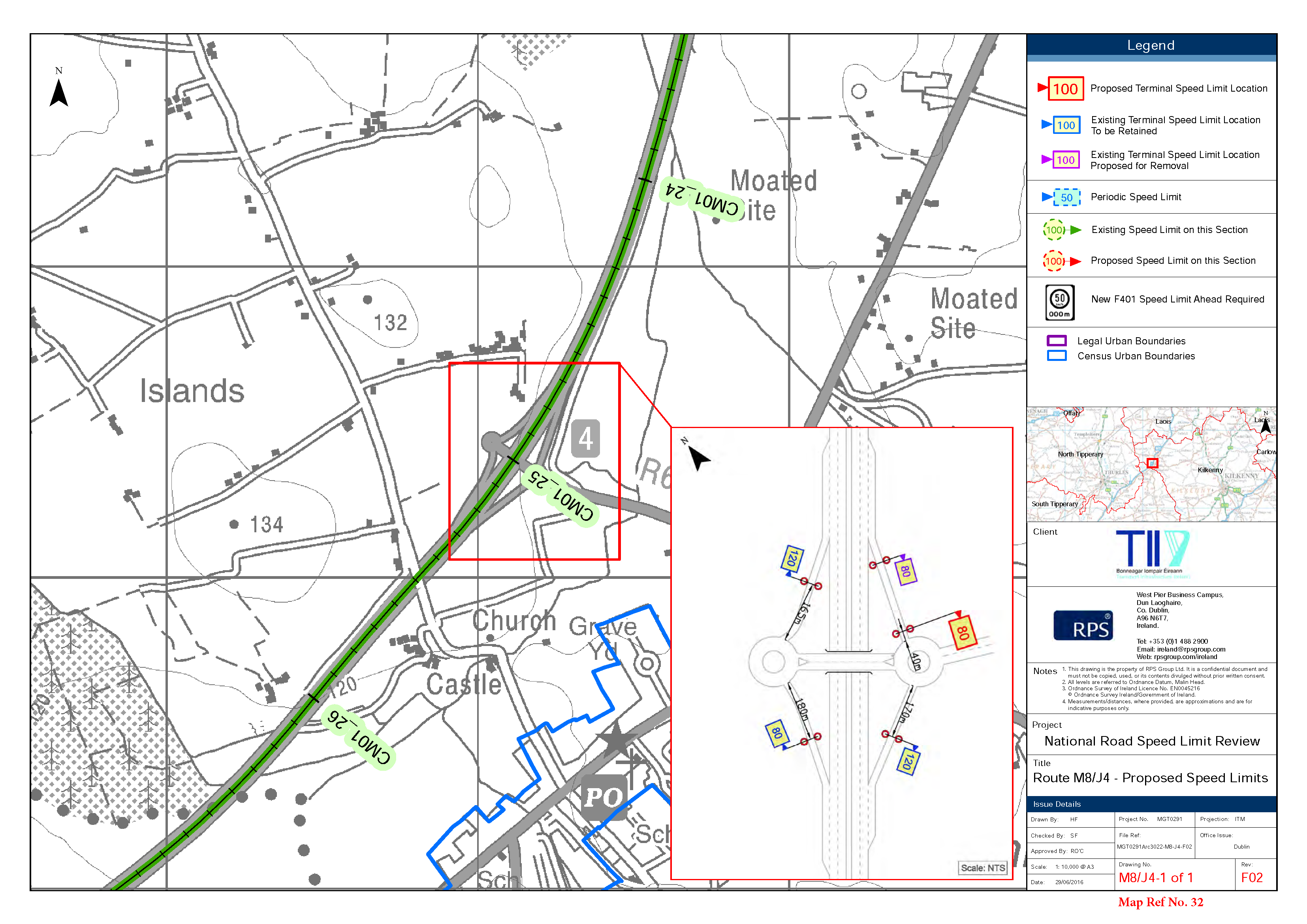
10. The following lengths of M8 Motorway Ramps in Kilkenny: (Map Ref No 32, M8/J4-1 of 1)
(a) M8 Motorway southbound on-ramp at Junction 4 (Urlingford Interchange) for a distance of 170m south-west from the intersection of the roundabout with the on-ramp.
(b) M8 Motorway northbound off-ramp at junction 4 (Urlingford Interchange) for a distance of 180m south from the intersection of the roundabout with the off-ramp.
(c) M8 Motorway northbound on-ramp at junction 4 (Urlingford Interchange) for a distance of 165m north-east from the intersection of the roundabout with the on-ramp.
(d) M8 Motorway southbound off-ramp at junction 4 (Urlingford Interchange) for a distance of 40m north-east from the intersection of the roundabout with the off-ramp.
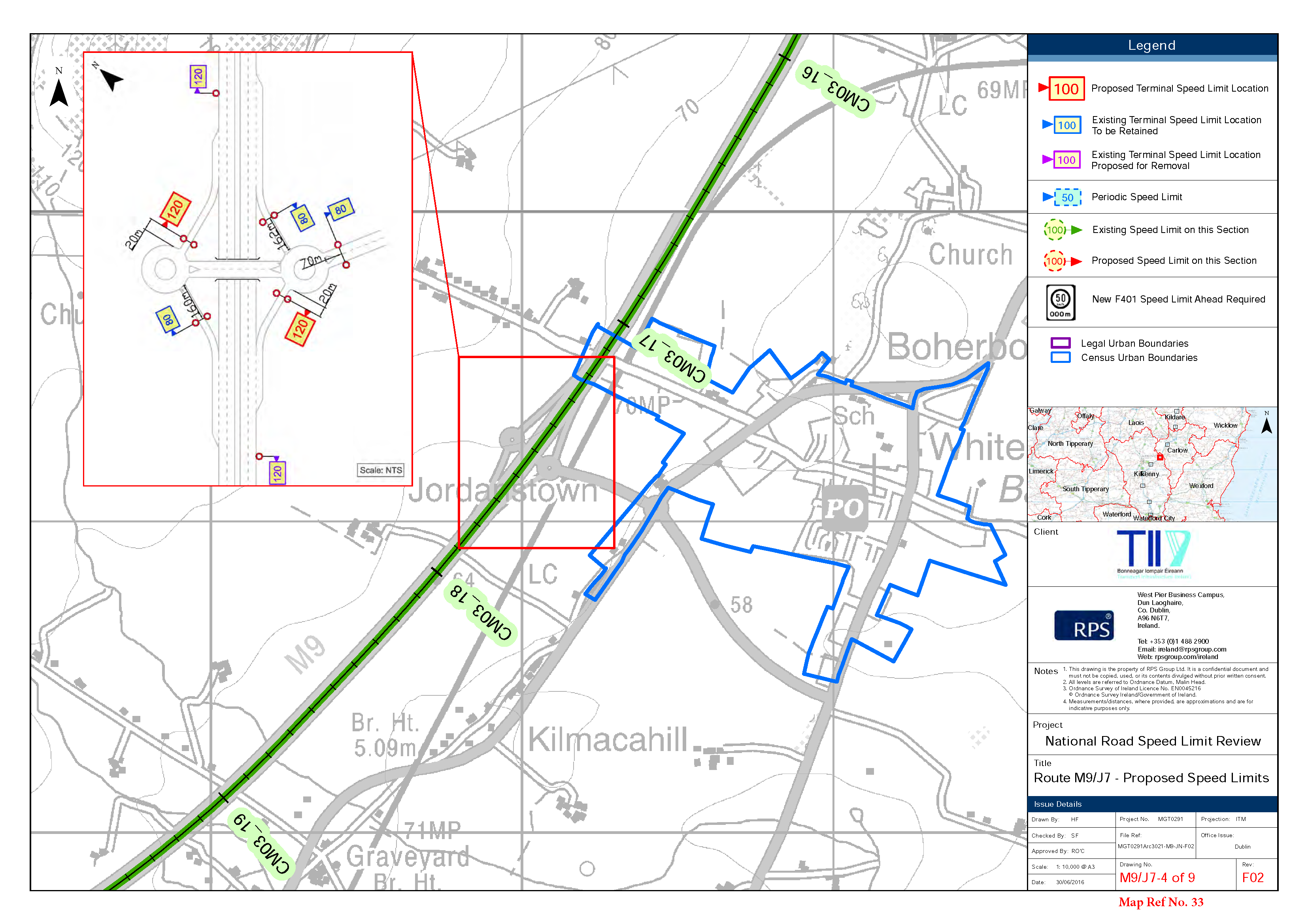
11. The following lengths of M9 Motorway Ramps in Kilkenny: (Map Ref No 33 M9/J7-4 & J8-5 & J9-6 & J10-7 of 9)
(a) M9 Motorway northbound off-ramp at Junction 7 (Paulstown Interchange) for a distance of 160m south-west from the intersection of the off-ramp with the roundabout.
(b) M9 Motorway northbound on-ramp at Junction 7 (Paulstown Interchange) for a distance of 20m north-east from the intersection of the on-ramp with the roundabout.
(c) M9 Motorway southbound on-ramp at Junction 7 (Paulstown Interchange) for a distance of 20m south-west from the intersection of the on-ramp with the roundabout.
(d) M9 Motorway southbound off-ramp at Junction 7 (Paulstown Interchange) for a distance of 162m north-east from the intersection of the off-ramp with the roundabout.
(e) M9 Motorway southbound on-ramp at Junction 8 (Rathbourne Interchange) from a point 255m east of the nosing between the northbound and southbound on-ramps, to a point 70m north-east of the nosing between the on-ramp and the M9 mainline in the southbound direction.
(f) M9 Motorway northbound off-ramp at Junction 8 (Rathbourne Interchange) from a point 45m north-east of the nosing between the off-ramp and the M9 mainline in the northbound direction, to a point 125m west of the nosing between the northbound and southbound off- ramps.
(g) M9 Motorway southbound off-ramp at Junction 8 (Rathbourne Interchange) from a point 45m north-east of the nosing between the off-ramp and the M9 mainline in the southbound direction, to a point 190m south-west of the nosing between the northbound and sout hbound off-ramps.
(h) M9 Motorway northbound off-ramp at Junction 9 (Danesfort Interchange) for a distance of 180m south-west from the intersection of the off-ramp with the roundabout.
(i) M9 Motorway northbound on-ramp at Junction 9 (Danesfort Interchange) for a distance of 40m north east from the intersection of the on-ramp with the roundabout.
(j) M9 Motorway southbound off-ramp at Junction 9 (Danesfort Interchange) for a distance of 140m north-east from the intersection of the off-ramp with the roundabout.
(k) M9 Motorway southbound on-ramp at Junction 9 (Danesfort Interchange) for a distance of 10m south west from the intersection of the on-ramp with the roundabout.
(l) M9 Motorway northbound off-ramp at Junction 10 (Sheepstown Interchange) for a distance of 100m south from the intersection of the off-ramp with the roundabout.
(m) M9 Motorway northbound on-ramp at Junction 10 (Sheepstown Interchange) for a distance of 200m north from the intersection of the roundabout with the on-ramp.
(n) M9 Motorway southbound off-ramp at Junction 10 (Sheepstown Interchange) for a distance of 95m north from the intersection of the off-ramp with the roundabout.
(o) M9 Motorway southbound on-ramp at Junction 10 (Sheepstown Interchange) for a distance of 30m south from the intersection of the roundabout with the on-ramp.
Clár ábhair
Ábhair
Tuarascálacha
Observations
Observations
Speed Limit at the dangerous blind exit from the Roadstone Quarry entrance road onto the N24 at New Aglish
We the residents of New Aglish would like to petition Kilkenny County Council to adjust the speed limits on the N24 Waterford Limerick Road at the Roadstone Quarry entrance at New Aglish...
Extend the following reduction in the speed limit 1.The following roads at Ballygriffin: (Map Ref No 25, N24-3 of 3)
I wish to recommend a reduction to the speed limit on the N24 from New Aglish just before the New Aglish Junction into Roadstone to Ballygriffin where the proposed reduction to 80 KPH is proposed to...
Submission for change to the speed limits on Mill Lane (L6731) in Gowran
We the residents of Mill Lane (L6731) and Mill Road would like to petition Kilkenny County Council to adjustment of the speed limits on L6731 from the current limit of 80KM/h to 50Km/h under the...