1. Introduction
In line with The Planning System and Flood Risk Management – Guidelines for Planning Authorities, a staged approach has been taken to the appraisal and assessment of flood risk for Amendment No. 2 of the Callan Local Area Plan 2009-2020.
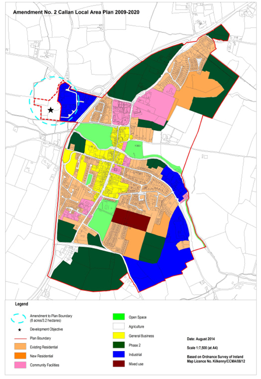
The proposed Amendment involves the extension of the LAP boundary to include an 8 acre site at Westcourt, Callan as per Map 1. The land will be zoned ‘Agriculture’. The ‘Agriculture’ zoning objective to be included in the Plan is as follows:
Objective: To conserve and protect agricultural land from interference from non-agricultural uses. To prevent development of agricultural land adjacent to development areas which would prejudice the future expansion of the town, except in exceptional circumstances where there are site specific development objectives for the provision of certain types of development.
Permissible uses: Agriculture, horticulture, public service installations, uses identified in site specific development objectives.
Open for Consideration: Public open space, guesthouse, restaurant, nursing home, dwelling houses in certain limited cases, halting site, private open space, other uses not contrary to the proper planning and sustainable development of the area.
It is proposed to include a site specific objective for this land as follows:
To facilitate the development of a residential complex (10 units approx.) initiated by the Camphill Community with ancillary small scale socio-economic uses related to the activities of the residents of the development, and to provide for a pedestrian link from the lands to the town centre, subject to the following:
- The development must not interfere with the ecological integrity of the adjacent Kings River which forms part of the River Barrow and River Nore SAC, a Natura 2000 site. Any future development (including pedestrian link) of the lands will be subject to Appropriate Assessment in accordance with Article 6 of the Habitats Directive.
- A site-specific Flood Risk Assessment appropriate to the type and scale of the proposed development and a site specific justification test if required must be submitted at planning application stage in line with the DoEHLG Guidelines “The Planning System and Flood Risk Management”, November 2009.
- Any developments proposed for the lands at Westcourt must be connected to the foul sewer network for treatment of waste water. Such developments will only proceed subject to the local treatment plant having capacity to adequately treat the additional load. It must be shown by proposals that all storm water can be appropriately collected, stored and treated so as not to affect the quality of water bodies.
- The archaeological importance of the site must be safeguarded by protecting archaeological sites and monuments (including their setting), and archaeological objects, including those that are listed in the Record of Monuments and Places, and in the Urban Archaeological Survey of County Kilkenny or newly discovered sub‐surface archaeological remains. Any proposed development in the vicinity or confines of archaeological monuments will require an archaeological assessment and the preparation of an archaeological impact statement for submission as part of any planning application for development within this area.
- When innovative layouts and exceptional design for living are achieved, strict adherence to the development management standards for new residential developments as set out in Chapter 12 of the County Development Plan 2014-2020 will not be required, provided the proposed designs can be demonstrated to satisfy the social and physical needs of the occupants.
1.1 Disclaimer
It is important to note that compliance with the requirements of The Planning System and Flood Risk Management - Guidelines for Planning Authorities, and of the Floods Directive 2007 60/EC is a work in progress and is currently based on emerging and incomplete data as well as estimates of the locations and likelihood of flooding. In particular, the assessment and mapping of areas of flood risk awaits the adoption of the finalised Catchment-based Flood Risk Assessment and Management Plans [CFRAMs]. As a result, this Flood Risk Assessment is based on available information.
Accordingly, all information in relation to flood risk is provided for general policy guidance only. It may be substantially altered in light of future data and analysis. As a result, all landowners and developers are advised that Kilkenny County Council and its agents can accept no responsibility for losses or damages arising due to assessments of the vulnerability to flooding of lands, uses and developments. Owners, users and developers are advised to take all reasonable measures to assess the vulnerability to flooding of lands in which they have an interest prior to making planning or development decisions.
1.2 Structure of a Flood Risk Assessment (FRA)
The Guidelines recommend that a staged approach is adopted when undertaking a Flood Risk Assessment (FRA). The recommended stages are briefly described below:
• Stage 1 ~ Flood Risk Identification
To identify whether there may be any flooding or surface water management issues that may require further investigation. This stage mainly comprises a comprehensive desk study of available information to establish whether a flood risk issue exists or whether one may exist in the future. This stage also includes collation of relevant local information.
• Stage 2 ~ Initial Flood Risk Assessment
If a flood risk issue is deemed to exist arising from the Stage 1 Flood Risk Identification process, the assessment proceeds to Stage 2 which confirms the sources of flooding, appraises the adequacy of existing information and determines what surveys and modelling approach is appropriate. The extent of the risk of flooding should be assessed which may involve preparing indicative flood zone maps. The initial assessment may determine that sufficient quantitative information is available, appropriate to the scale and nature of the changed land use or development proposed for the necessary decision to be made.
• Stage 3 ~ Detailed Flood Risk Assessment
This is carried out to assess flood risk issues in sufficient detail and to provide a quantitative appraisal of potential flood risk to a proposed or existing development or land to be zoned, of its potential impact on flood risk elsewhere and of the effectiveness of any proposed mitigation measures.
1.3 The Sequential Approach
The sequential approach in terms of flood risk management is based on the following principles: AVOID - SUBSTITUTE - JUSTIFY - MITIGATE – PROCEED.
The primary objective of the sequential approach is that development is primarily directed towards land that is at low risk of flooding (AVOID). The next stage is to ensure that the type of development proposed is not especially vulnerable to the adverse impacts of flooding (SUBSTITUTION).
The Justification Test is designed to rigorously assess the appropriateness, or otherwise, of particular developments that, for various reasons, are being considered in areas of moderate or high flood risk (JUSTIFICATION). The test is comprised of two processes, namely the Plan-Making Justification Test and the Development Management Justification Test. Only the former (Plan-Making Justification Test) is relevant to a Strategic Flood Risk Assessment for a Plan, and this is described as follows.
Justification Test for Development Plans (See p.37 of the Guidelines)
“Where, as part of the preparation and adoption or variation and amendment of a development/local area plan, a planning authority is considering the future development of areas in an urban settlement that are at moderate or high risk of flooding, for uses or development vulnerable to flooding that would generally be inappropriate as set out in Table 3.2 of the Guidelines, all of the following criteria must be satisfied:
- The urban settlement is targeted for growth under the National Spatial Strategy, regional planning guidelines, statutory plans as defined above or under the Planning Guidelines or Planning Directives provisions of the Planning and Development Act 2000, as amended.
- The zoning or designation of the lands for the particular use or development type is required to achieve the proper and sustainable planning of the urban settlement and in particular:
- Is essential to facilitate regeneration and/or expansion of the centre of the urban settlement
- Comprises significant previously developed and/or under-utilised lands;
- Is within or adjoining the core of an established or designated urban settlement;
- Will be essential in achieving compact or sustainable urban growth;
- There are no suitable alternative lands for the particular use or development type, in areas at lower risk of flooding within or adjoining the core of the urban settlement (This criterion may be set aside where section 4.27b applies- ‘Existing undeveloped zoned areas at risk of flooding’).
- A flood risk assessment to an appropriate level of detail has been carried out as part of the Strategic Environmental Assessment as part of the development plan preparation process, which demonstrates that flood risk to the development can be adequately managed and the use or development of the lands will not cause unacceptable adverse impacts elsewhere.
N.B. The acceptability or otherwise of levels of any residual risk should be made with consideration for the proposed development and the local context and should be described in the relevant flood risk assessment.”
MITIGATION is the process where the flood risk is reduced to acceptable levels by means of land use strategies or by means of detailed proposals for the management of flood risk and surface water, all as addressed in the Flood Risk Assessment. The decision to PROCEED should only be taken after the Justification Test has been passed.