DAR - Section 3 The archaeological context
DAR - Section 3 The archaeological context (Download Section 3: The archeological context)
SECTION III: The ARCHAEOLOGICAL CONTEXT
3.1 INTRODUCTION
This section examines the archaeological findings to date at the Masterplan site and discusses the below ground archaeology and potential of the area. Research and development led archaeological monitoring and excavation has been conducted within and in the immediate vicinity of St Francis’ Abbey.
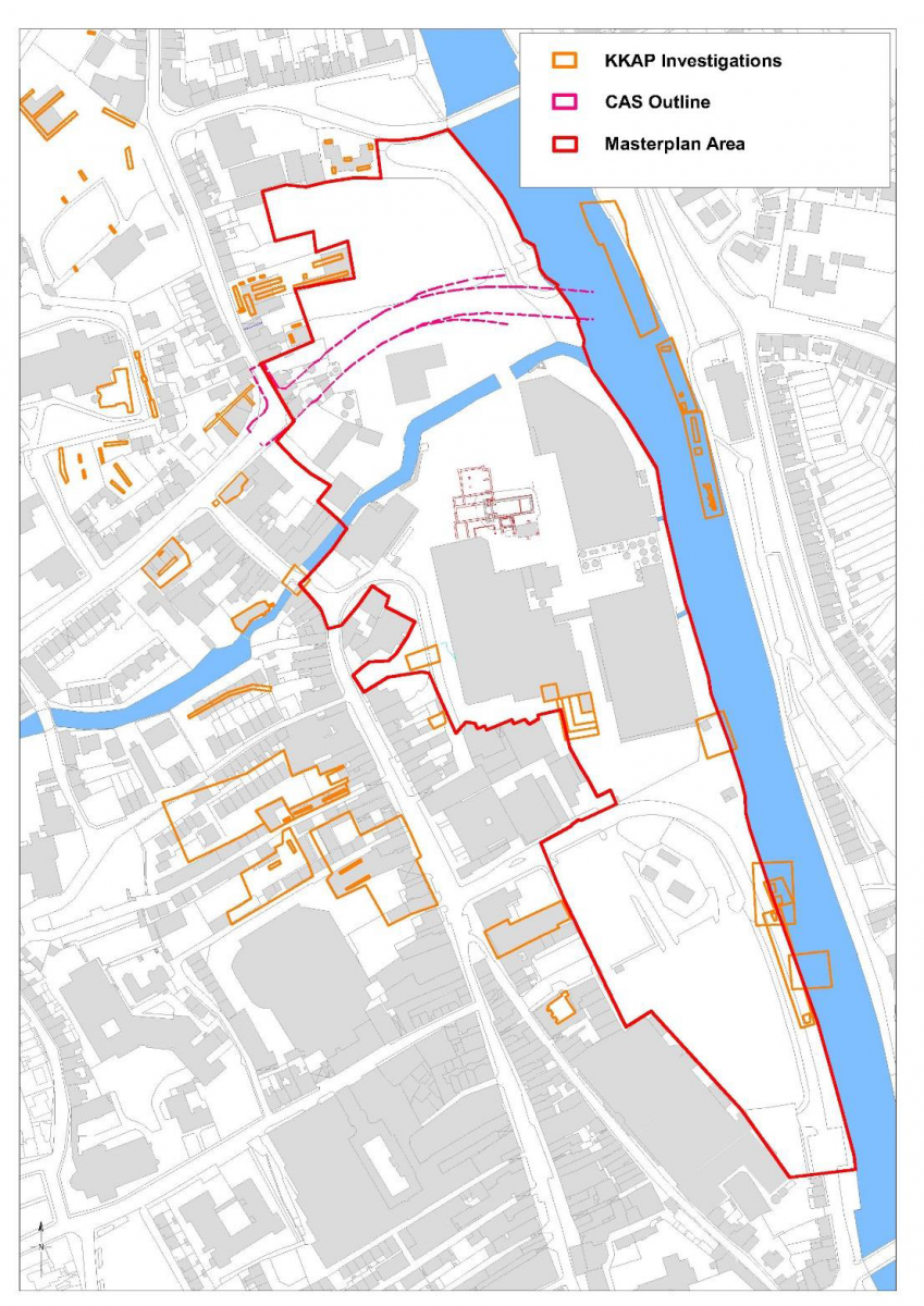
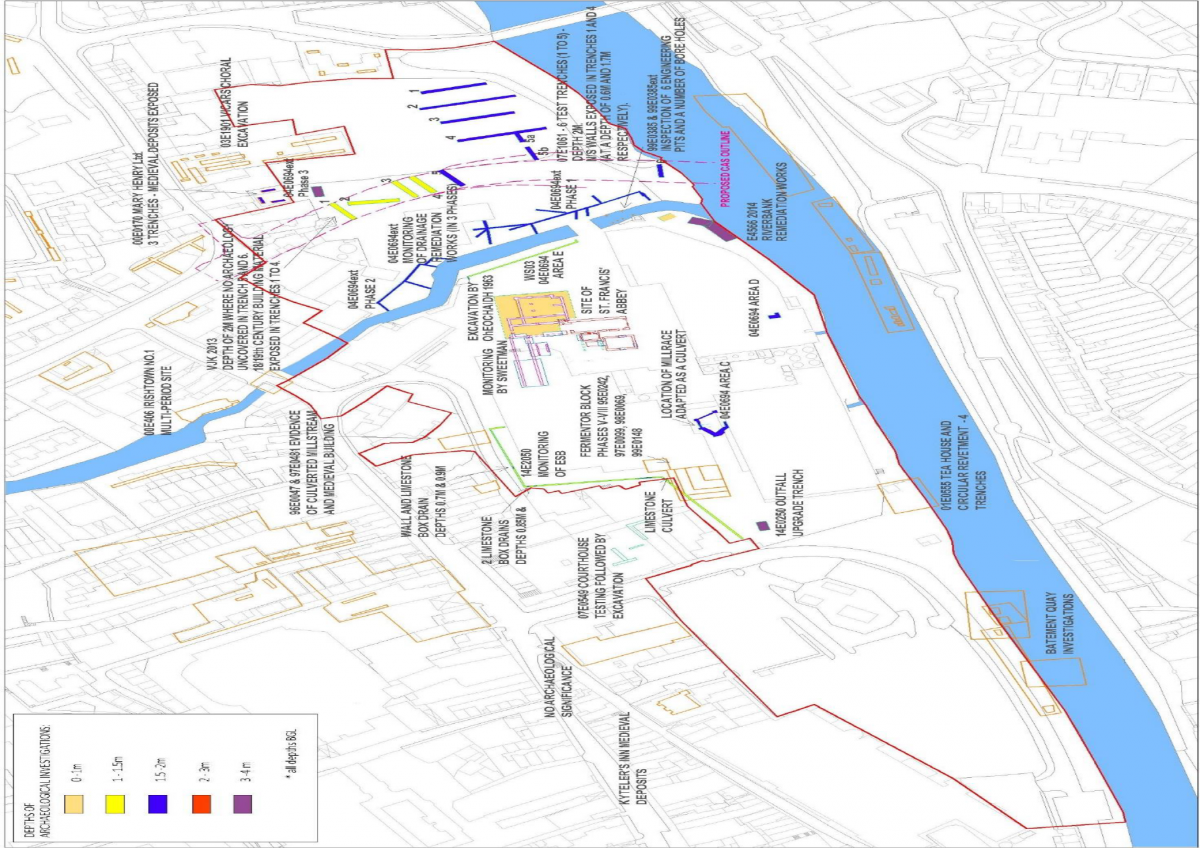
Fig 17. KKAP Overview – Map showing investigations as plotted from the Kilkenny Archaeology Project (noted investigations in brown date up to 2006).
3.1.1 Archaeological Investigations within the Masterplan Area
The development lands of St. Francis’ Abbey Brewery located on the western bank of the River Nore cover a 7.5 hectare area. The site is located within the zone of archaeological potential for Kilkenny city (KK019–026). The area contains a number of extant archaeological remains as well as being host to many excavations, testing schemes and phases of monitoring since the early 1960s. Upstanding remains include an abbey consisting of an unroofed chancel and tower (KK019-026101), a river wall (which forms part of the town wall circuit), the remains of a bridge (KK019-026102), a 17th Century wall monument (KK019-026183), a font (KK019-026150), an inscribed slab (KK019-026151), and Evans turret and wall walk (with foundations dating to the 13th Century). To the north of the River Breagagh in the north-west corner of the site is the Bull Inn (KK019-026107) and the site of a 16th/17th century house (KK019-026122), whilst on the banks of the river Nore is the site of a watermill (KK019-026124), a site which has been investigated by Paul Stevens as part of the River Nore Flood Alleviation Scheme.
One large excavation took place in the immediate surroundings of the Abbey under the direction of Marcus Ó hEochaidhe, this was followed by the monitoring of the demolition of brewery buildings by David Sweetman. It had been previously assumed in excavation.ie reports that these archaeological works took place in 1966 and 1969, but a study of Sweetman’s original site notes and cross referencing sources places them securely in 1963 and 1970 respectively.
Ó hEochaidhe 1963 - Excavation
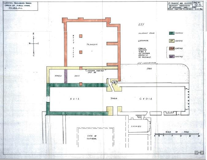
Archaeological investigations began in 1963 with an excavation to the immediate north and west of the standing abbey ruins by Marcus Ó hEochaidhe. The results of this excavation were never fully published, however site plans in the records of the OPW, combined with record photography from the excavation, provide an insight into the below ground remains of the abbey. An estimate of the extent of the area opened for excavation would be 40m x 30m (Figure 18), with a depth varying between 0.4m and 1m from the then existing ground level (this was gathered from the photographic archive of the excavation).
Archaeological works exposed the foundations of the north aisle of the religious complex dating to the 14th Century, along with those of a substantial transept to its north dating to the 15th/16th Century (Figure 18). Photographic records of the exposure of at least one medieval burial near the transept, along with the discovery in the north transept of the Delahunty grave slab (with Gothic inscription and dated 1624, Plates 26 and 27), indicate the potential for more human remains in the immediate surroundings.
Figure 18. Plan of St. Francis’ Abbey OPW 1966.
Plates 26 and 27 Photo of Delahunty grave slab as recorded by in situ by Ó hEochaidhe in the 1963 Excavation (on the left) and as existing (on the right).
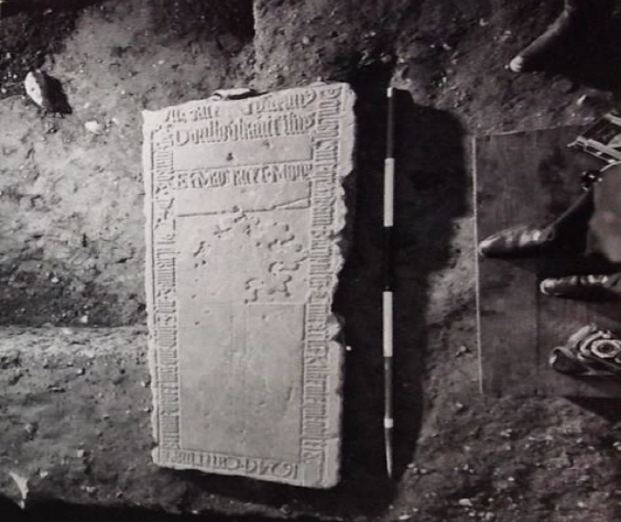

The potential for human remains was verified by Sweetman in the proceeding monitoring briefs of the 1970s. Interestingly, Con Manning, in an article on the Delahunty grave slab in the Old Kilkenny Review (2007), notes that; “burial at the site continued as late as 1687, as shown by a recorded inscription, but may have ceased after 1698, when the site was given over for use as military barracks”*.
*Con Manning 2007 The Delahunty Grave Slab in St Francis’ Abbey, in OKR No. 59 pgs 48-51
Sweetman 1970 - Monitoring
The next series of archaeological investigations in the vicinity of the abbey began in September 1970 and continued intermittently for the next decade. In this case all archaeological monitoring of demolition works and service development was carried out by David Sweetman. The findings were unpublished, however, monitoring notes and a number of sketches were on record at the DAHG. These investigations uncovered the walls of the west range (a large area to the immediate south of the nave), a cloister walk wall, the western wall of the sacristy and a substantial amount of human remains. Initial investigations to the immediate west of the standing tower of St. Francis’ Abbey located the east end of the south wall of the nave (the wall as it ran westwards had been completely destroyed by the insertion of a modern sewer system). Another trench was dug to expose the south west corner of the nave and in turn verified the full length of the south wall. Both of these trenches exposed a number of burials, dated to “no later than the 18th Century”*. A mechanical digger was then used to remove rubble from the demolished brewery and expose large areas of the west range and in turn the remains of 15th century walls. Due to the concentration of haphazard fill of a 17th and 19th century date in this area, Sweetman suggests that this part of the west range was in fact a cellar, which was filled up with rubble, prior to been covered with reinforced concrete for the construction of the brewery.
*David Sweetman’s monitoring notes 1969-71, unpublished.
Figure 19. Plan of St. Francis’ Abbey, below ground remains and areas of investigation.
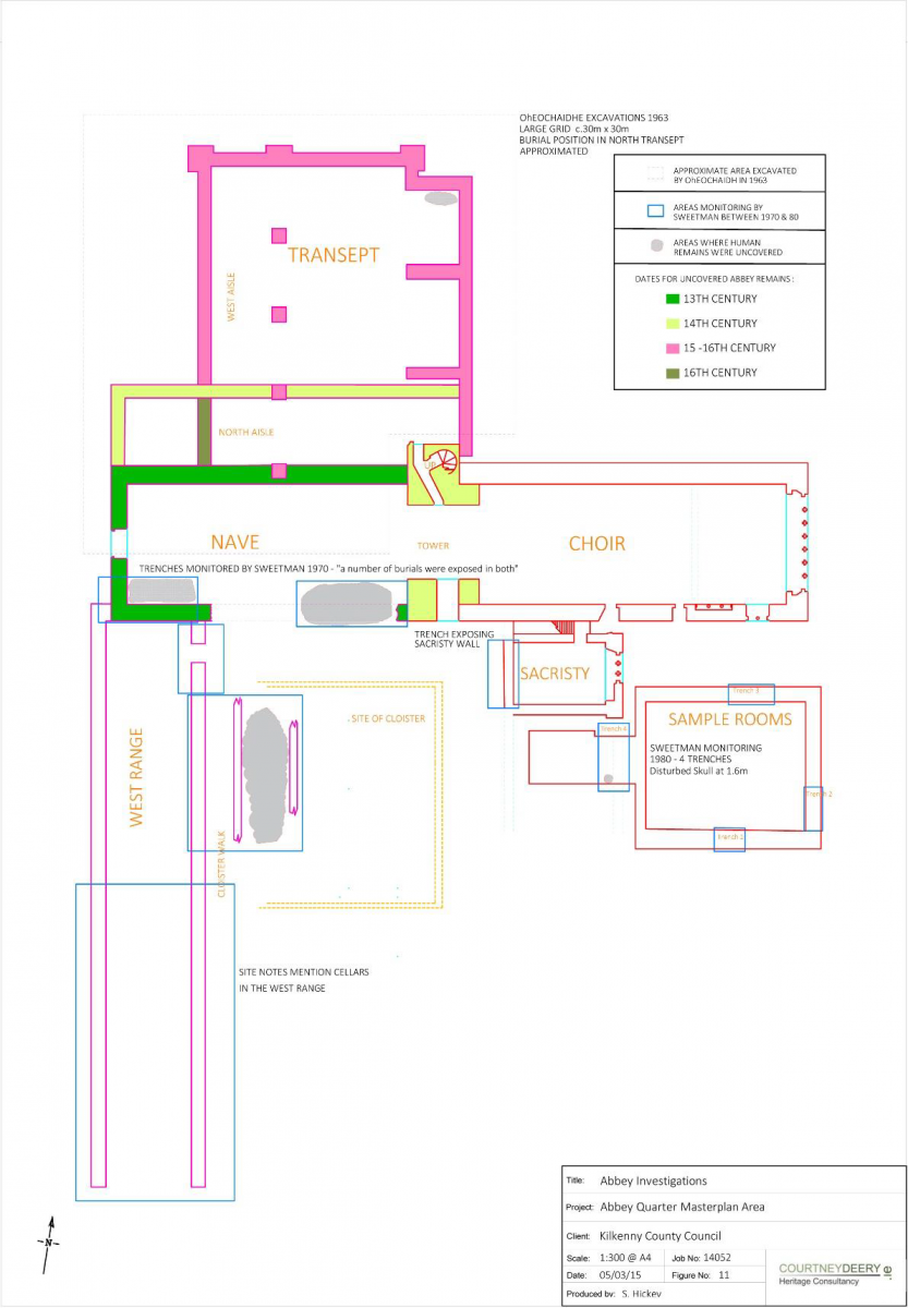
In early October 1970, another cutting was made in the west range in an attempt to locate the cloister. Following the removal of a large amount of reinforced concrete, the cloister walk was discovered, however the flagstones of the walk had been removed except for a few which had been used for secondary burials. The cloister walk (measuring 1.8m wide) proved to be full of burials, many piled on top of one another, and not orientated in the traditional Christian east-west fashion. This indicates a hasty interment and suggests they were possibly victims of disease.
Pottery sherds from the site were overwhelmingly 17th century and of English origin, they also included one German wine container (a Belermine Jug). A few sherds of 13th century English ware and sherds of 13th century French wine jugs were also uncovered (these were mingled with the 17th century wares and 20th century debris).
Excavation continued in December 1970 following the breaking up of concrete by the demolition crew in the northwest section of the cloister area. 19th century disturbance had removed the expected northwest corner of the cloister, although further areas of the west wall were uncovered and planned.
Additional archaeology works took place over the next few years, following the uncovering of features during site development or service works. In February 1971 a small area of the friary was investigated, locating the extreme north end of the east wall of the west range. March 1973 also saw a site visit by Sweetman to ascertain if an exposed wall was part of the original friary. A one day investigation took place recording what proved to be the west wall of the sacristy.
The opening of four trial trenches (trenches 1 to 4 in Fig.19) was supervised by David Sweetman in January 1980 prior to the laying of foundations for a new building immediately to the south of the existing choir. This building still stands and is referred to as the “Sample Rooms” on site (Fig.19 above). The first three test trenches were dug to a depth of 1m (which was below the formation level of the proposed building) and exposed rough cobbling over a fill of brick, stone, ashes and charcoal. The fourth trench revealed the east face of a substantial wall running south from the south eastern corner of the sacristy. Sweetman notes that this wall (south of the sacristy marked on Fig.19) is the remains of the outer facade of the eastern wall of the chapter room marked on plans drawn during the excavation by Ó hEochaidhe in 1963. Plans of this area from 1963 are not available for viewing but their mention does indicate that Ó hEochaidhe carried out investigations south of the choir. Testing exposed 4.5m of this wall face and it was taken down to a depth of 1.6m. The wall stands at 0.8m above its footing (which consist of 0.8m of foundations). The western wall of the chapter room was not located. A human skull (belonging to a burial noted as being in a “disturbed position”) was exposed at the bottom of the trench and reburied in situ. It was noted that south of this trial trench there is a modern building (erected in 1976), the construction footprint of which exposed a large amount of modern rubble and disturbance. Following testing it was concluded that the construction of the proposed building (the ‘sample rooms’) would not disturb any features of archaeological interest.
Figure 20. Masterplan area, below ground remains and areas of investigation.
Archaeological Site Assessment and Testing within the Masterplan Area
Between the mid-1990s and 2007, a number of archaeological assessments were carried out, throughout the brewery complex (Figure 20). The assessments and resulting investigations related to a number of localised development and up grading schemes on the brewery site itself as well as large riverside infrastructural projects. Works requiring archaeological monitoring and investigation included the multiphase development of a number of fermentor blocks, drainage remediation works, the construction of a wastewater treatment plant, and a flood alleviation scheme related to the River Nore.
Monitoring works on KKCC Drainage (to the southwest of St. Francis’ Abbey) 1996/7
Two archaeological investigations took place in 1996 and 1997 to the immediate west of the Masterplan area relating to the construction of a new main drainage system in Kilkenny. These works involved archaeological monitoring of open cut-trenches, ground stabilisation in advance of thrust-boring, and the thrust-boring operation itself. Monitoring was carried out under licence by Martin Reid and Patrick Neary (License Refs. 96E0047 and 97E0481 respectively). The former monitoring brief noted the foundations of a medieval rectangular stone building, which was cut by an eighteenth-century mill-race, which was itself demolished and built on by a later mill-race enclosed in a tunnel. This culverted mill-race is believed to be that which runs from the Breagagh River, south-eastward under Parliament Street, through the theatre carpark, onto the Brewery (where it was uncovered during monitoring, under licence 04E0694), and into the Breagagh. The interpretation of this material is that the mill-race was used as a rubbish dump by the locals before it was culverted in the post-medieval period.
A battered wall foundation on the south side of Mill Lane, at No 20 Vicar Street was revealed. This extended in an easterly direction towards the River Nore, on which a mill was located, the remains of which are still upstanding. The battered foundation extended beyond the limit of excavation, which was 2m deep beneath present ground surface. The existing upstanding wall is built on top of the earlier foundations at a depth of approx. 0.6m below present ground surface.
At the junction of Irishtown and St Canice’s Place at a depth of 1.4m below the road surface, Patrick Neary noted in his brief (License Ref. 97E0481), that a considerable quantity of pottery, bone, horn, leather and glass was recovered, some of which no doubt came from the medieval period, but also included a large amount of post-medieval material.
Fermentor Block (Phase V to VIII)
A series of monitoring works and test excavations were undertaken in relation to the phased development and extension of an existing fermentor block between 1995 and 1999. These investigative works took place over 4 construction phases (Phase’s V-VIII) under archaeological licenses 95E0242, 97E0099, 98E0069, and 99E0148. All phases of the development were in close proximity to each other. Initial excavation (Phase V) revealed an organic silt deposit (with a depth of 1.32m), thought to be of possible medieval date, sealed below a made ground fill of construction rubble (seen to a depth of 1.25m below ground level).
Prior to the construction of a new fermentor block at the brewery in 1997 (part of Phase VI), Ed O’Donovan carried out an archaeological assessment License Ref. 97E0099. A small test trench measuring 2m x 1.3m was opened, and revealed yellow boulder clay sealed by a layer of sterile black silty clay at a depth of 2.5m to 1.25m below a layer of demolition rubble. It was hoped that some trace of the mill race identified on Rocque’s Map of 1758 would be uncovered during this investigation, however, nothing was uncovered, and it is believed it was positioned further south.
Investigation of Phase VII of the fermentor development took place under license 98E0069, this consisted of two trenches, one aligned east-west along the line of 3 no. pile caps and the other aligned north-south along the long axis of the proposed block on its western side, test trenches revealed masonry wall foundations. These two structures were considered to be of post-medieval date on the basis of their size, nature and stratigraphic relationship with the deposits recorded in their vicinity, and indicated further structural remains at the southern end of the brewery compound.
Phase VIII was carried out under License Ref 99E0148, and took part in two stages. The first stage involved a trench which was 11.5m long, 1m wide and excavated to a depth of between 1m and 2.7m. A thin layer of gravel was identified over boulder clay. This was overlain by a soft, silty, organic material that consistently produced occasional post-medieval pottery. It directly underlies a mortar layer representing barracks activity. Two parallel limestone walls orientated northeast/southwest were uncovered. The walls were post medieval and made from rubble limestone bonded with a white lime based mortar. These walls were left in situ. The second stage saw the opening of a north-south aligned trench, 20m long, 1.30m wide and excavated to a depth of between 1m-3.10m, and confirmed these findings.
Improvements to flood defences, drainage system and waste water treatment facilities between 1999 and 2007 resulted in a series of monitoring briefs and test trenching being carried out under licence (License Ref. 99E0385, 99E0385ext, 00E0406, 00E033, 00E0405, 01E0608, 01E0821, 04E0694, 04E0694ext, and 07E1061) within the masterplan area of the St. Francis’ Abbey Brewery site.
Monitoring for the River Nore Flood Alleviation Scheme – River Breagagh:
In 1999 the decision to commence with the Nore Flood Alleviation Scheme necessitated the riverbed level to be reduced by bulk excavation. This excavation was essential to remove any stabilised PCB contaminated material due to a spillage from a refrigerated unit over twenty years earlier. These works, commenced under License Ref. 99E0385 by Margaret Gowen & Co. Ltd. included the initial excavation of 6 test pits in the riverbed, a survey of the medieval wall, and the monitoring of geotechnical bore holes. These pits were excavated in pumped, sand-bagged locations roughly 1.5 x 1.5m. Of the six, four were opened along the medieval wall and two were opened on the northern side adjacent to a modern concrete wall. Only test pit, number four yielded anything of archaeological significance; two sherds of medieval pottery. Excavation on the southern side, against the medieval wall, revealed that the gravel extended down for at least 0.8m and that it possessed modern debris to that depth. No medieval material was noted in any of the material excavated along the southern side, although large quantities of modern bottles, some delph, plastics and some metal objects were removed for identification. No archaeological features or artefacts were uncovered during the bore hole sampling.
Archaeological assessment and monitoring of dredging in the River Breagagh included the detailed survey of the former northern boundary wall of the friary complex and what is regarded as the City Wall in this location. The survey established that the foundations and lowermost 1.50m or more of the wall was composed of original medieval masonry. It also established that the wall had very shallow foundations and that it incorporated a footing of some 1-3 courses in depth.
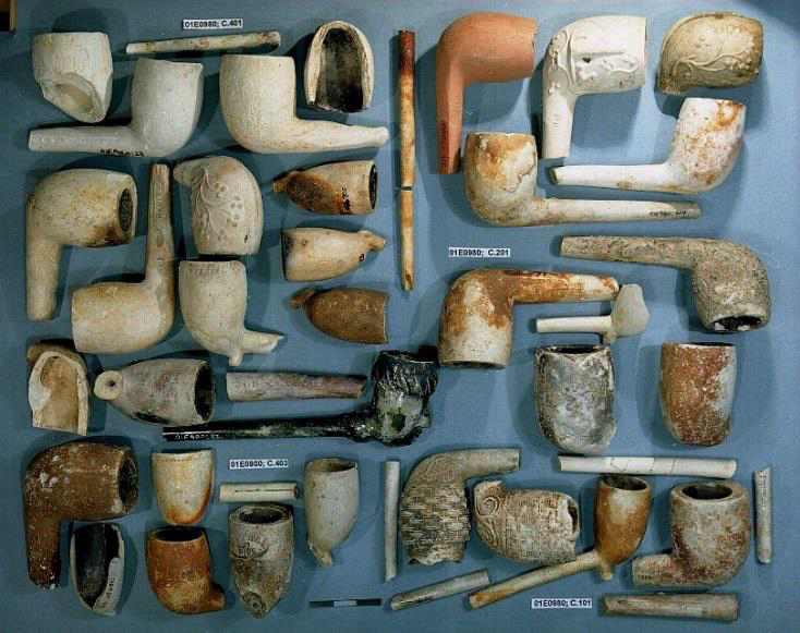
Plate 28 Collection of clay pipes uncovered during the River Nore Flood Alleviation Scheme (courtesy of Margaret Gowen & Co. Ltd.)
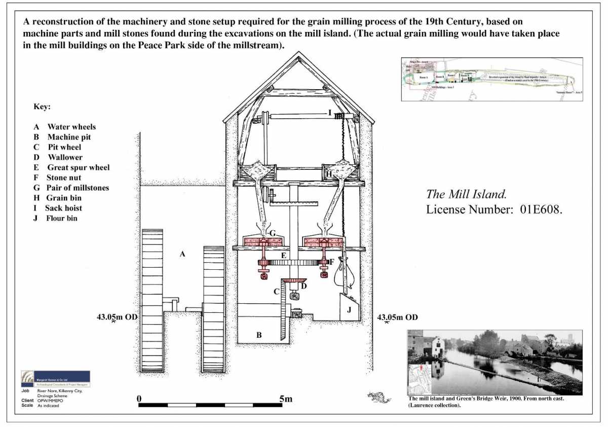
An extensive programme of archaeological testing, monitoring and excavation was undertaken by Margaret Gowen & Co. Ltd as part of the River Nore Flood Alleviation Scheme between 2001 (License No. 00E0406 and 00E033 and 00E0405, 01E0608, 01E0821) and 2005. The drainage scheme covered approximately five kilometres of rivers running through the medieval city, and the subsequent twenty excavations, and vast amount of varied stray finds give a unique insight into the city’s prehistory and history. As part of this programme archaeological excavations were carried out at Green’s Bridge, Mill Island and Green’s Bridge Weir. Between 2001 and 2002 Mill Island and Green’s Bridge Weir were excavated in advance of removal of the island and remodelling of the weir. This site formed part of a large milling complex that spanned both sides of the River Nore (Figure 21).
Six areas were opened over two seasons of excavation. Seven phases of construction of the mill buildings on Mill Island were identified, from the use and modification for the processing of corn, to dereliction, and destruction. These areas were excavated to sterile river gravels. North of the plan area the late 17th to early 18th century abutment of Green’s Bridge was excavated in 2003, informing a current understanding about historic bridge construction. The original Green’s Bridge was north of the modern bridge, in line with Green Street.
Figure 21 Reconstruction of Mill based on archaeological remains on the mill island (courtesy of Margaret Gowen & Co. Ltd.).
Seven excavations took place either within or in the immediate proximity of the masterplan area as part of mitigation for the River Nore Drainage Scheme. Combining both above ground and underwater excavation a series of investigations into 18th/19th Century pleasure houses, an early modern gazebo, revetment walls, and a stone jetty, were carried out. Five buildings situated along the river’s edge at Bateman Quay (all annotated as ‘Pleasure Ho[use]’ on the First Edition Ordnance Survey map) were excavated (under License Refs. 01E0554 and 01E0555).
Excavation work was undertaken in June 2002 on a riverside stone jetty by Paul Stevens (License Ref. 01E0554), accompanied by underwater monitoring and excavation by Dr Niall Brady of ADCO Ltd (License Ref. 01E0036). Two phases of domestic mooring usage were revealed dating from the mid-17th/early 18th century and the later 18th/early 19th century respectively. The rebuilding relates to a rise in water levels associated with the building of weirs both up and downstream. The structure was built of reused vernacular architectural stone fragments, dating from the medieval, Tudor and post-medieval periods, and had been heavily truncated by a number of modern drainage and landscaping features.
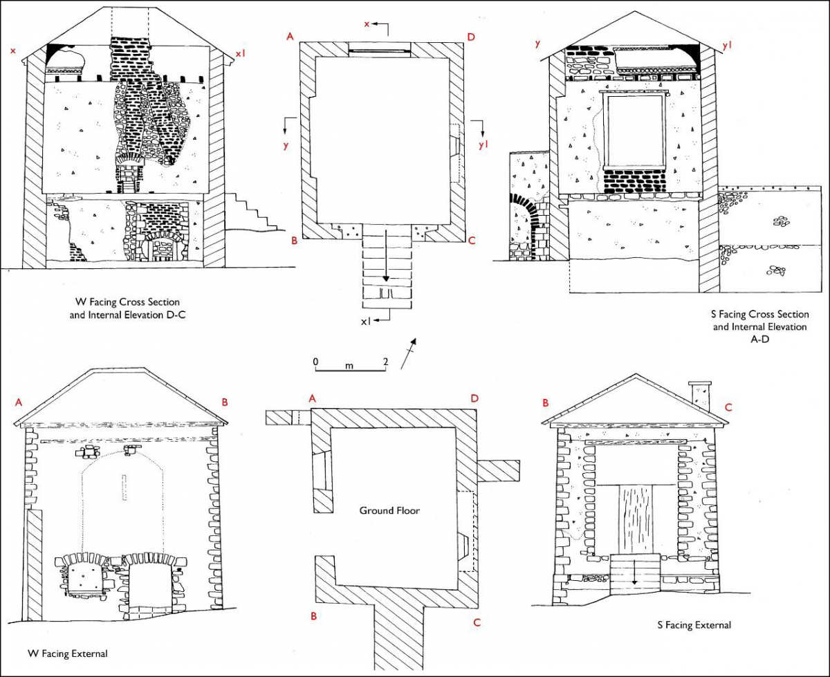
This was followed by excavation of the five “Pleasure House” buildings dating to the end of the 18th and the beginning of the 19th century. Full measured survey and rectified drawings of the upstanding house remains and that of a circular revetment wall were carried out (Figure 22 below). A high concentration of post medieval glass bottles, clay pipe, weapons, and pottery were retrieved during the monitoring of this scheme.
Figure 22 Plan, section, and elevations of Pleasure House (courtesy of Margaret Gowen & Co. Ltd.) excavated under License 01E0555.
Monitoring of On-Site Drainage Remediation Works:
Between 2004 and 2006 a series of drainage remediation works within Smithwick’s Brewery required licensed monitoring. Commencing in 2004 in the southern portion of the brewery, works were carried out by archaeologist Kevin Lohan (of Margaret Gowen & Co. Ltd under license Ref. 04E0694). Pre-disturbance and the pre-emptive redesign of a number of proposed trenches meant that the only archaeology encountered in five separate area’s (A to E below) was a culverted medieval millstream (which had previously been uncovered in 1996/7 further to the west in the monitoring of the carpark of the Watergate Theatre under Licence Refs. 96E0047 and 97E0481). In 2006 the licence was extended to cover works in the northern portion of the brewery, carried out by Brenda O’Meara under license 04E0694ext (Phase’s 1 to 3 below).
Area A & B - Following consultation between the directing archaeologist, the NMS, and the client, it was decided that a redesign of the proposed trenching scheme was necessary, this was due to their close proximity of the standing remains of St. Francis’ Abbey and potential burial grounds. Re-lining of existing service trenches eliminated any requirement to excavate, and in turn any impact on potential archaeological remains.
Area C – An 8m north-south test trench (depth 2m) in Area C crossed the line of a probable medieval millstream adapted in the 19th Century into a culvert. The eastern façade of the trench revealed the slightly disturbed west face of an arched culvert was exposed. The limestone masonry of the arch spanned an area measuring 2.4m wide. The apex of the arch was exposed 0.8m below the ground. The eastern extent of this masonry culvert was not revealed. The remainder of the millstream, east to the river was culverted in the late 20th century.
Area D - Required the installation of an access chamber in an area that was already disturbed by an earlier chamber. There was no further excavation into undisturbed ground and there was no archaeological implications for this work.
Area E – This involved monitoring of a 55m east-west trench, in the kegging area, running adjacent to and just south of the River Breagagh. Layers of made ground, dark silts and natural river gravel all noted but nothing of an archaeological significance.
In 2006 a second phase of drainage remediation works was carried out which required archaeological monitoring at the site. The license (Ref No. 04E0694ext) was extended to cover these works. They were carried out by Breda O’Meara and focused in the northern portion of the brewery on the northern side of the River Breagagh. The works were carried out in 3 phases. Phases 1 and 2 were composed of linear east-west trenches adjacent to the River Breagagh and were excavated to a depth of 2m. These service trenches revealed a sterile black riverine silt clay at between 1.2m and 2m below the present ground level. This material was sealed by a thick deposit of mixed building rubble and gravelly sand interpreted as late nineteenth /early twentieth-century reclamation and levelling. Two layers of concrete yard surface separated by gravel filling were recorded in the uppermost section of the trenches. Phase 3 saw deep excavations required to accommodate the insertion of petrol interceptor tanks. Between 2.7m and 3.5m of material was removed exposing a deposit of black riverine silt clay, c. 0.65m thick, over river gravel. No archaeological material was recovered from these riverbed and accumulated river bank deposits. These deposits were sealed by late 19th/early 20th-century rubble and gravel reclamation and levelling deposits and by concrete yard surfaces.
Monitoring of the Development of a Waste Water Treatment Facility:
In 2008 the development of a wastewater treatment plant, an associated service road, and general landscaping within the north-eastern corner of the masterplan area necessitated archaeological investigation. Under License Ref. 07E1061 Nikolah Gilligan of Margaret Gowen & Co Ltd monitored a total six test trenches. Four east–west and two north–south-orientated trenches were machine excavated across the footprint of the proposed site in an area known as the orchard. Remnants of two north–south-orientated stone walls were noted during testing. The walls appeared to have been fairly disturbed by post-medieval and modern activity on the site, which took place in the form of millrace reclamation and drainage works. The first wall was noted in Trench 1, at a depth of 0.6m below the present ground surface (c. 43.1m OD). It is situated in the same location as the original eastern boundary wall visible on Rocque’s 1758 map and was probably a renovated version of the original boundary wall. The second feature was located in Trench 4, at a depth of 1.7m below the present ground level (c. 42.55m OD). This was probably the remains of a north–south dividing wall which was constructed within an east–west-orientated burgage plot. The plot probably belonged to a house fronting onto Vicar Street, depicted on Rocque’s Map of 1758.
Testing for the Proposed Kilkenny Central Access Scheme 2010-12:
The requirement for archaeological test trenching was one of several mitigation measures contained in An Bord Pleanála’s decision regarding the granting of permissions for the construction of the Kilkenny Central Access Scheme (KCAS). Both underwater and above ground testing was required. An underwater investigation to sections of the riverbed that will be impacted on by the insertion of a proposed bridge crossing associated KCAS was carried out by ADCO in 2010, under License Ref.10E323. No archaeological features were recorded.
As part of works associated with the KCAS archaeological test trenching took place in July 2012, and was carried out by Colm Flynn for Valerie J Keeley Ltd. Previously unknown archaeology was identified in four of the six test trenches excavated to the north of the River Breagagh. The nature of the archaeology present and the artefactual evidence indicates that it relates to 18th-19th century buildings and associated yards. It is possible that the archaeology that was identified relates to buildings depicted on Rocque’s map, dating to the 1758. The buildings on Rocque’s map are shown along one side of a roadway named Mill Lane. It has been suggested that Mill Lane is the cobbled area identified in Test Trench IV. Buildings are not shown in the location of the archaeology in the 1st ed. OS 6-inch map of the area, which dates to the 1839. Buildings are also depicted in this area on 3rd ed OS maps of the area, which dates to the 1910’s. It is unlikely these buildings are the same as those shown on the earlier Rocque’s map. Test Trench VI excavated along the western shore of the River Nore identified riverine silt deposits, and modern quarried stone, and no evidence of archaeology.
Monitoring of a trench for an underground ESB cable 2010-12:
The monitoring was carried out by Gill McLoughlin of Courtney Deery Heritage Consultancy Ltd. on behalf of Diageo Limited (License Ref:14E0250), in July and August 2014. The trench for the ESB cable snaked its way for 160m at the southern end of the Masterplan. A series of 19th and 20th century walls, box drains, and culverts were uncovered. A number of which tie in with Rocque’s map of 1758 and the 1st ed. OS 6-inch map of 1839.
In general the stratigraphy of the trenches was as follows:
|
Depth |
Context no. |
Description |
|
0-0.28m |
C1 |
Concrete. |
|
0.28-0.45m |
C2 |
Loose deposit of stones and coarse sand, rounded and angular cobbles average diameter 0.08m. |
|
0.45-1m |
C3 |
Mixed deposit of light-mid orange-brown sandy clay with inclusions of red brick, slate and mortar. There were many variations in the deposits at this level along the length of the trench, however they all contained some modern inclusions, indicating disturbance. |
The route of the ESB trench was extensively disturbed and with the exception of one sherd of medieval pottery from a disturbed context, all the finds were of 19th –20th century date. Remnants of a number of walls were identified, many of which appear to correspond with walls depicted on the early OS mapping of the area. Most of the walls were similar in size and construction, and date to the 19th century, with possibly one or two walls dating to the 18th century. A culvert identified at the north end of section 1 of the trench may relate a structure depicted possibly on Rocque (1758) and on the 1st ed. OS 6-inch map. This culvert may represent the line of an earlier mill stream which issued to the River Nore (Plate 29). The culvert was oriented west-northwest – east-southeast and was constructed of large limestone blocks measuring up to 0.4m x 0.5m. It was present at 0.45m deep, was 1m wide and was cemented in on both sides.
Plate 29 Monitoring ESB trench, culvert section 1
The results of the archaeological monitoring of the ESB trench correspond well with previous monitoring of a service trench in the immediate vicinity in early 2014 (Flynn, between February-May 2014 in relation to the Smithwicks Visitor Attraction Project) which identified two stone walls thought to be part of an 18th -19th building, roughly corresponding with the location of the culvert and a post 19th century stone wall corresponding with the wall and associated flagstones in the south end of the trench.
Monitoring of an outfall upgrade by a licensed archaeologist took place to the rear of the courthouse within the brewery yard in 2014. This excavation examined an area 7m x 4m and over 3m deep. The area had been previously extensively disturbed due to two existing manholes and no archaeological features or finds were revealed. A possible riverine deposit (a dark grey brown silt) was detected below c. 1.5m.
Fig 23. Geotechnical Investigations monitored by Courtney Deery Heritage Consultancy in 2013/14.
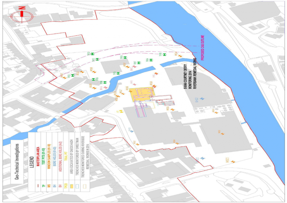
Monitoring of geotechnical site investigations comprising boreholes, test pits, window samples and river-bank grab samples was carried out in 2013 and 2014 by Courtney Deery Heritage Consultancy (Figure 23). Three boreholes, 11 test pits and 18 window samples were monitored. River gravel depths and soil stratigraphys were established throughout the centre of the masterplan area. These investigations are detailed in Appendix D. No features of archaeological significance have been identified as a result of these investigations.
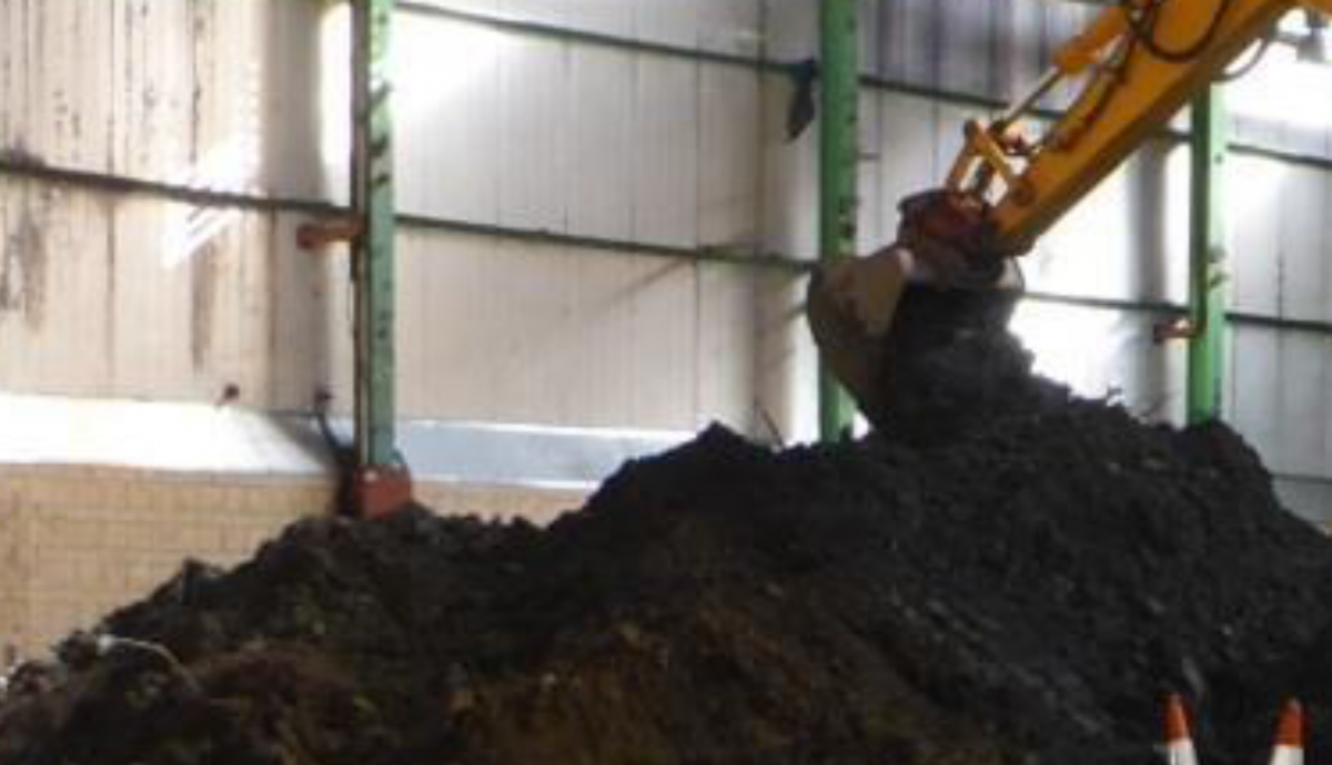
Archaeological monitoring, under Ministerial Consent took place in 2014 on the south bank of the River Breagagh adjacent to the confluence of the River Nore. The works involved the removal of contaminated soil from the riverbank. During these works all excavated spoil was spread for inspection and metal detected for the purpose of finds retrieval. In order to facilitate the excavation, a sheet pile screen and two sheet piled coffer dams were installed to prevent collapse into the river and to protect the works from inundation by the river. Within the sheet piled screen, the area was excavated to a depth of 0.5m and within that area, the two coffer dams were excavated to a depth of 4m. The sheet piles were located c.9m from the nearest point of Evan’s Tower.
Plate 30 Metal Detection of Spoil
The riverbank soil proved to be very disturbed with the upper c.1.3m comprising a mix of organic river silts, rubbish and stones. Included in this material were some dumped structural stones, roughly squared limestone similar to those used in the tower. In total nine stones were retrieved and have been stored adjacent to the tower. They ranged in size from 0.27m x 0.15m x 0.16m to 0.57m x 0.35m x 0.26m. Below 1.3m the material comprised loose grey river gravels, which for the most part appeared to be undisturbed and at c. 3m the river gravels changed to a yellow grey colour.
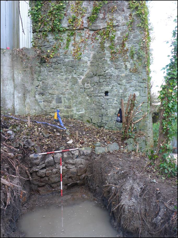
Excavation revealed the continuation of a stone wall which adjoined the northeast corner of the tower and was partly visible prior to excavation. This wall was constructed of similar stone to that used in the tower and appears to represent a riverbank revetment. It is unclear whether this feature is contemporary with the tower or not. Average dimensions of the stones were 0.45m x 0.2m and five rough courses were uncovered, with the wall extending below the depth of the excavation. The wall was exposed for a length of 1.6m, depth of 1.1m and was oriented northwest-southeast. It continued beyond the excavation area to the southeast and remains in situ. The thickness of the wall was not established as it extended outside of the scope of the remediation works. It was not possible to draw the section of exposed wall due to rapidly rising water levels from the river within the trench. After cleaning and photographing, the wall was covered in a layer of terram and the excavation area was backfilled with clean stone. The layer of terram will protect the wall for any future investigations. No artefacts of an archaeological interest were recovered from this area.
Plate 31 Revetment wall at Evan’s Tower
3.1.2 Areas investigated outside the Masterplan Area
Naturally an examination of archaeological investigations that took place in close proximity to the masterplan area may also shed light on potential finds and remains within the site. In this case, four sites are mentioned below, three of which abutt the plan area, and conform with general findings from numerous investigations across the Masterplan site.
The common thread often being that, where ground breaking works uncovered archaeology, it often fell into a stratigraphy of made ground, sitting over post medieval foundations, sitting over organic, silty medieval deposits, which, along with evidence of a history of flooding, occasionally featured the burial of human remains. Two sites at the rear of 15-16 and 19 Vicar Street, tested in 2000 and 2003, indicate dark silty layers of medieval date sitting below post medieval walling relating to outhouses. Likewise, the full excavation in 2008 at the courthouse facing onto Parliament Street adjacent to the Grace’s Castle site uncovered post medieval structural development, a prison burial plot, evidence of land drainage, burgage plots and a large amount of domestic medieval evidence (with artefacts of ceramic, wood, bone, and iron). Knowledge of these sites indicates the potential of archaeology in the Masterplan area.
No. 1 Irishtown 02E1592
This excavation took place to the north of the River Breagagh, near Irishtown Gate, approximately 120m west of St Francis’ Abbey and 300m west of the Breagagh and Nore confluence. Prior to the excavation of the area (60m southwest x 20m southeast/northwest) testing had revealed a substantial linear timber structure (Licence Ref. 00E406). The excavation allowed an examination of the archaeological deposits to the north of the river within the area of the medieval borough of Irishtown and provided a valuable insight to the development of the area. A significant medieval settlement was revealed with similar structures and revetments found in Dublin, Drogheda and Cork. Five phases of archaeological activity was excavated, the earliest of which dated to the later 12th century right through to the post-medieval period*.
Amongst these findings were the discovery of portion of a post and wattle building which is likely to date to the late twelfth century. This is the first structure of this type to be revealed in Kilkenny the evidence of these excavations it is possible that reclamation may have commenced during the late 12th century.
One of the interesting findings was that the modern day plot boundaries did not evolve until the late 13th or early 14th centuries. This may indicate a certain fluidity in the evolution of this part of the settlement during the previous centuries. Also a poorly preserved baseplate revetment was the first example of this type to be revealed in Kilkenny, although it is likely that examples of this type of riverside carpentry survive elsewhere in Kilkenny**.
Features and structures revealed included riverside fences and revetments, property plots, structures, a cess pit and masonry walls. Finds included animal bone, leather, copper alloy objects and pottery.
The remains of a stone weir consisting of limestone blocks bonded with mortar, shown the mid-19th century OS maps was also revealed. This arrangement allowed the water of the Breagagh to be largely diverted into a mill race which led off to the southeast, this feature would have extended into the Masterplan area, south of St Francis’ Abbey.
*I Doyle (2003) ‘Medieval Settlement’ in the River Nore Flood Alleviation Scheme unpublished report Margaret Gowen & Co Ltd
**C. Ó Drisceoil (2003) ‘Kilkenny reclaimed: the archaeological evidence for medieval reclamation in Kilkenny City’, in Old Kilkenny Review 55, 58-69
Testing exposing medieval deposits at rear of 19 Vicar Street - 2000
The development of a private dwelling at the rear of 19 Vicar Street, which abutts the masterplan area was, in accordance with planning, subject to an archaeological assessment and testing plan. This took place in April of 2000 under licence ref. 00E0170 by Mary Henry Archaeological Services Ltd. Three test trenches were dug to a depth of 1.7m below ground level (OD 44.76m) and uncovered the remains of relatively modern walls, probably associated with outhouses that stood on the site. It was under these walls that a series of deposits of archaeological interest were revealed; dark grey sand and silt layers at a depth of 1.1m, and at a depth of 1.5m a very dark, organic, grey to black silty sand with a sherd of medieval pottery, possibly local-ware (which may have been a stray find). It was concluded that the deposits on site indicated medieval activity.
Excavation of the late medieval foundations of the ‘Vicar’s Choral’ at 15-16 Vicar Street – 2003/5
In advance of the construction of a four-storey hotel at 15-16 Vicar Street in 2003 a series of test trenches were excavated by John Tierney of Eachtra Archaeological Projects (License Ref 03E0707). Like the site at 19 Vicar Street, this site also abutts the masterplan area and along with medieval deposits also uncovered the remains of an early post-medieval structure at the site's Vicar Street frontage. The foundations of the preceding buildings on 15 and 16 Vicar’s Street were encountered at a depth of 0.5m (Trench 1) and 1m (Trench 2) below the sites ground surface. Both walls were 1.1m thick, and the location of the foundation walls and their dimensions tallied with a number of references to the house of the Vicar’s Choral, a later medieval structure. Potential archaeological sediments were identified and further testing followed the demolition of modern structures at the site and the removal of modern overburden. This was carried by Catherine McLoughlin of Stafford McLoughlin Archaeology (License Ref. 03E1901), confirming the presence of the remains of a substantial masonry structure at the site's street frontage and uncovered medieval and post-medieval archaeological deposits and features to the rear of this structure. These deposits in turn were excavated in the summer of 2004 under an extension to license (License Ref. 03E1901).
Excavation of the deposits uncovered to the rear of the street-fronting structure was undertaken by the writer under an extension to license 03E1901 in the summer of 2004. The excavation also revealed the floor plan of the street-fronting property.
The structure uncovered was a substantial two-celled rectangular building that appeared to be the remains of the 'Vicar's Choral', a late medieval building demolished in the modern period. The structure was constructed of mortar-bonded stone (mostly limestone) and was floored with a variety of ceramic tiles, bricks and stone flags and extended across the entirety of the street frontage of 15-16 Vicar Street. A smaller, single-roomed structure uncovered to the rear of the building appeared to be a later extension. Although the floor plan of the structure was largely uncovered, the building was not entirely excavated but was preserved in situ beneath the newly built hotel.
To the rear of the stone structure, modern buildings, foundations and a cellar had removed any archaeological stratigraphy that may have been at the same level as the structure. However, excavation in the area of the new hotel's basement revealed a series of medieval pits and stake-holes overlain by layers of possible flood deposits. A substantial stone-built wall with an L-shaped return was also uncovered in this area. Although the function of this structure was unclear, it did appear to be of at least early post-medieval date. To the rear of the hotel's basement, in the area of a new carpark, layers of medieval and post-medieval silty deposits were preserved beneath the new development.
Further monitoring at the site of this development in 2005 did not uncover any further archaeological remains.
Courthouse Excavation – 2007/8
A testing programme was carried out by Maedbh Saunderson on behalf of Arch-tech Ltd in 2007 (Licence Ref.07E0549), following a proposed development to partly demolish existing buildings in the eastern part of the Kilkenny Courthouse complex, and construct a four-storey office block, linking atrium, and associated services and elements on the cleared site. The Courthouse itself is a Protected Structure and is immediately adjacent to the site of Grace’s Castle and within the site of the later County Gaol. The site is located between Parliament Street and the River Nore, an area which from c. 1207 formed part of the medieval Irishtown south of the Breagagh River, and north of the earlier Hightown. The land to either side of Parliament Street was divided into long narrow burgage plots which would have contained a house and shop on the street frontage, with outhouses, sheds, yards, gardens and orchards to the rear. The Urban Archaeological Survey (Farrelly et al. 1993) identifies a castle built immediately to the west of the proposed development by William LeGros in the 13th century. In 1566, James Grace gave the castle to the corporation to use as the County Gaol. The Parliament Street Courthouse dates from 1786, when it was established in the upper part of the soon-to-be-closed County Gaol, with substantial remodeling in the early 19th century. The lower part was converted to the City Gaol by 1824, which served as the Bridewell from 1871 to 1946. Five test trenches with a total length of 50m were excavated in June of 2007 and a number of features of archaeological interest were identified. These trenches uncovered a burial, a number of medieval deposits, a well, and some post medieval walls. As a result, it was considered that there was a good likelihood that further archaeological material relating to the medieval burgage plot and the post-medieval/early modern gaol may remain unidentified within the footprint of the proposed development, and a full excavation was recommended.
In November of 2008 a crew of 25 carried out a follow up excavation, directed by Maedbh Saunderson (License Ref. 08E0462), at the rear of the Courthouse. The site proved to be a rich archaeological area producing over 1000 contexts which resulted in over 200 excavated features. There were 4000 sherds of medieval pottery and 2000 sherds of post-medieval pottery recovered. Almost 500 pieces of extremely well preserved wood were recovered from the site. This wood consisted of stakes and timbers from the wood-lined cesspits, as well as eight wooden artefacts, eleven coins, three brass artefacts, over two-hundred iron artefacts, thirty bone artefacts, two copper-alloy objects with gold and thirty bone artefacts. Pottery provisionally dated from the late 14th to 20th century was recovered from the site.
The site consisted of remnants of medieval domestic activity revealed as pits, wood-lined cesspits and plot boundaries/burgage plots. These cesspits and pits had large amounts of domestic refuse. The burgage plots/property divisions were evident on the site as shallow, long ditches orientated both north–south and east–west. These earliest phases of activity were sealed by the introduction of soil layers possibly from another area of Kilkenny. The pottery provisionally identified from these features dates from the mid-12th to 14th century.
The evidence for the later phases of activity was directly linked to the changes in the usage of the building. The structure changed from domestic (Grace’s Castle) to civil use, firstly as a gaol in 1566 and then as both gaol and courthouse in 1794. During this post-medieval phase there was evidence for land consolidation. Several ditches excavated were filled with porous building material, possibly to assist in the draining of the land. The site was located within the old flood-plain of the River Nore. This was evident during the excavation by the continuous problem of flooding encountered on the site.
Twenty-three inhumations were recorded to the rear of the site. The burials excavated were probably felons executed within the confines of the prison environment. Detailed historical, environmental, and artefactual analysis was ongoing in 2008, however this excavation report has not been fully published.
3.1.3 Summary of archaeological investigation works
Over the past fifty years an extensive number of archaeological investigations, excavations, testing, monitoring, and recording has taken place in the Masterplan area. As the site sits at the heart of the Zone of Archaeological Potential for Kilkenny City, any ground breaking works have the potential to uncover archaeological remains. Through a detailed study of existing cartography, extant archaeological monuments and features, and an examination of the findings from literally hundreds of test trenches, bore holes, window samples, dredged river areas, and archaeological assessments, it is possible to generate an understanding of where the potential for archaeology is high.
Marcus Ó hEochaidhe’s excavations in 1963 combined with monitoring through the 1970s by David Sweetman of St. Francis’ Abbey began to show the extent of the medieval ecclesiastical remains, revealing that the standing tower and unroofed choir were once flanked by a transept, nave, sacristy, cloister, and cloister walk. There is a strong likelihood that further remains of the Franciscan abbey (including a chapter house, and living quarters) are present below ground. The uncovering of a series of inhumations within the abbey points to its regular use as a burial ground as well as the potential that further human remains are present in the environs.
Monitoring and testing within the Masterplan area has created an understanding of how the general area developed along with how it was dictated by the flooding of the Rivers Nore and Breagagh (culverts and millstreams are seen throughout). This development stems from the riverside prehistoric stray finds associated with fishing uncovered in the River Nore Drainage Scheme, to the medieval layout of burgages plots (appearing as shallow, long ditches orientated both north–south and east–west) seen in Rocque’s Map of 1758, to a gradual land reclamation, and the development of mills and adaption in the use of the river, up to the plan’s area strong association with brewing. At the southern end of the site we see evidence of a slow land reclamation practices - where a wooden palisade at the bank would have a second palisade built riverside, and be filled with debris, whereby the process would be repeated. Revetments and wooden barriers are regularly noted in testing reports close to the quay. Whilst to the north made ground of red brick and demolition rubble of the 19th/20th century helped raise the ground level.
The stratigraphy seen in archaeological investigations throughout the site commonly shows evidence of modern concrete, sitting above made ground, over evidence of post medieval walls or structural foundations, overlaying (an often sterile) organic dark silty clay with occasional finds dating it to the medieval period, along with river silts and gravels, and a yellow boulder clay. A blend of archaeological remains, artefacts, and features are seen within the Masterplan area. Finds of possible plague victims from the medieval period, Franciscan abbey remains, ruined towers, city walls and defences, burgage plots, and medieval deposits, riverside pleasure houses with stone jettys, industrial mill houses, along with burials of felons from a 19th century gaol house, indicate an extremely rich and varied archaeological history.