Abbey Quarter Masterplan Areas Report Appendices
Abbey Quarter Masterplan Areas Report Appendices (Download Report Appendices)
APPENDIX A: St Francis’ Abbey Historic Sources
In 1544 a Grant of King Henry VIII of the Black and Grey Friaries and their possessions to the Soveraigne, Burgesses and Commons of Kilkenny.
CR/C9 – Copy of a translation of a Grant made by King Henry the 8th to the Sovereign- Burgesses and Commons of the Town of Kilkenny of the Black and Grey – Friaries and their possessions in the 35th year of his Reign
‘And the whole House [Satis] site? boundary ambit and precincts of the late Monastery or House of Franciscan Friars of Kilkenny, aforesaid in the said County, Commonly called the Grey Friars of Kilkenny. And the whole Church Belfry Dormitory, Hall, Chapter House, three Chambers a Kitchen, a House called the Garnen with three cellars under same House, and an enclosure within the Site of said late monastery or House, and all Edifices Messuages Gardens Lands tenements Orchards and heredutaments whats occurs with this appertaining in or within the Site Bounds Circuit and precincts of said late Monastery or House’.
CR/C18 – Letter Patent of Charles I (1640-1693)
‘... also all the houses scite ambit and precincts of the late Monastery or house of Franciscan Friars of Kilkenny aforesaid commonly called the Grey Friars of Kilkenny Late in the sais County and now in the County of the City of Kilkenny and all the churches belfries Domitories halls the Chapter House three bedrooms one kitchen a house called the garner with three cellars under said house and an enclosure within the said Scite of said Monastery or house of Grey Friars and also all the house edifices gardens orchards lands tenements and hereeditaments with their appurtenances within the said Scite ambit and precincts of the said late monastery or house of Grey Friars and all the castles messuages lands tenements mills weirs’.
CR/H 2 relates to a volume entitled ‘Folio Volume containing entries of leases and fee farms No 13’ entries appear under the headings; ‘The Comon Lande, St. John’s Lande, the Freren Landes’ dating to 1500-1678. The document discusses the leases on Grey Friar Abbey amongst other matters.
The following are leases dating from 1592 that relate to land holdings in and around St Francis’ Abbey then referred to as ‘Grey Friar Abbey’:
CR/I 24 - 18th July 1592 Lease past to John Rothe Fitz Jerkin, Burgess of two messuages, part of the ‘ Grey Fryers land’ for 61 years at 7 shillings and 4 pence.
CR/I 30 – 4th July 1595 Lease past to Katherin Ronan of Kellis (Kells) single woman, Patrick Gaffney her son, Walter Johns of Kellis and Margaret Ronan his wife, of a messuage and garden situated in the precinct of the late Monastery or house of the Grey Friars of Kilkenny, together with a ‘little void or wast place’ situated between the said house and the west end of the abbey, for 58 years at 1 shillings and 8 pence per annum.
CR/ I 60 - 19th October1632 Lease past to Richard Roth Fitz Edward, Alderman of a messuage a void room or garden situated within the precinct of the late dissolved house or Franciscan Abbey of the city, together with the cloister of the abbey, for 99 years 4 score and 19 years.
CR/I 103 - 4th July 1753 Lease past to William Archbold, Esquire, of the Franciscan Abbey situated in St Mary’s parish for ever at the yearly rate of 4 pounds.
‘Known by the name of the Franciscan Abbey not in the possession of the said William Archabold Smithwick Lying and being in the Parish of St Mary in the said City Together with all and Singular the houses Buildings Rights Members Appurtenances Privileges and Advantages.... To hold the said Houses, Gardens, Orchards and Buildings and every part and parcels thereof with the appurtenances’.
CR/H6 relates to a book that documents - A Concise History of the Corporation of Kilkenny with Catalogues of its Ancient Charters, Grants and Minute Books 1873.
Appendix B Irish Historic Towns Atlas Kilkenny Gazetteer
The following information was extracted from the Irish Historic Towns Atlas Kilkenny, Topographical Information by John Bradley (2000). It relates to features noted to lie within the Masterplan area. These structures/features and associated references are included in a gazetteer format.
Mills
St Francis’ Abbey Corn Mill, Water gate E., part of St Francis’ Abbey Brewery (q.v.) Grefryrs Mylle 1541 (Extents Ir. Mon. possessions, 200). Edmund Smithwick, oatmeal miller, 1846, 1856 (Slater). Corn mill 1850 (Val. 1), 1858-1910 (Val. 2).
Mill race, from Breagagh R., Water Gate W. to River Nore: water course, property of St Francis’ Abbey (see 11 Religion) 1540 (Carrigan, iii, 107); 1758 (Rocque); mill race 1841-1946 (OS).
Forges and smithies
Horse Barrack Lane N., in part of former starch factory (q.v.) 1869-1901 (Val. 2), 1871 (OS). Horse Barrack Lane, site unknown. Peter Dowling 1884 (Bassett, 141). Horse Barrack Lane, site unknown. Patrick Hennebery 1884 (Bassett, 141).
Distilleries
Parliament St E., on site of later St Francis Abbey Brewery (q.v.).1824 (Pigot). Distillery, malt house, corn stores and water mill 1827 (KM 24.1.1827). Incorporated in St Francis’ Abbey Brewery (q.v.) in 1827 (Halpin, 587). Location unknown. Rectifying distillery 1829 (KM 12.8.1829).
Breweries
St Francis Abbey Brewery, Parliament St E., in S. part of St Francis’ Abbey (see 11 Religion). St Francis Abbey Brewery, opened by Edmund Smithwick incorporating earlier distillery (q.v.) in 1827 (Halpin 586-7); 1831 (KJ 1841; Smithwick Brewery 1871 (OS). St Francis’ Abbey Brewery, 4 malt houses, saw mills, 2 steam engines, water wheel 1884 (Egan, 142-3). St Francis’ Abbey Brewery 1900-46; brewery 1983 (OS) St Francis’ Abbey Brewery 2000
Woollen manufactories
Chancellor’s Woollen Factory, Vicar St E. Chancellor’s Mills 1830; Chancellor’s Mills, grist, tuck and spinning mills 1841 (KJ 24.31830, 31.7.1841) Chancellor’s Woollen Factory 1841; woollen factory 1871 (OS). Closed in c. 1881 (Val. 2). Incorporated in chancellor’s Mill (q.v.) by 1946 (OS).
Starch manufactories:
Parliament St E., associated with St Francis’ Abbey Brewery (q.v.). 1841 (OS), 1870; closed in c. 1882 (Val. 2).
Services
Bull Inn, St Canice’s Place S. (04306335). Bulles Inn, opened in 1602 9Prim, 1862, 177). Closed by 1833 (KJ 9.2.1833). In ruins 1862 (Prim 1862, 1770). Part extant 2000.
Transport
Irishtown Bridge, Breagagh R., Irishtown to Water Gate (04406250). Bridgec. 1207; Cotterell’s Bridge 1269, 1352 (Berry, 124; Liber primus, 25). Repaired in 1568
(Ainsworth, 33). Widening ordered in 1759 (KCM 5.4.1759). Bridge at Water Gate 1833
(KJ 27.2.1833). Unnamed 1841-1999 (OS) Irishtown Bridge 2000.
Bridge, Breagagh R., King St to St Francis’ Abbey, associated with Grey Freren Gate. Said to have been built before 1540 (Hogan, 1884, 393).
Residences
St Francis’ Abbey (house), Parliament Street E., in St Francis Abbey brewery. Smithwick residence 1837 (KJ 15.11.1837).
Streets
Horse Barrack Lane ‘Road leading to monastery of the Friars Minor, 1498 (Liber primus, 103). Graiefreryn Street or Lane 1615 (Healy 389). Lane to the horse barracks 1715 (CB 17.9.1715). Horse Barrack Lane 1786 (FLJ 22.7.1786), 1835; St Francis Street 1830; St
Francis Abbey Street 1840 (KJ 29.4.1835, 4.12.1830, 17.6.1840). Horse Barrack Lane 1841 (OS).
Religion
St Francis Abbey, Water Gate E. Franciscan friary founded by Richard Marshal in c 1231- 4; new chancel built in 1321; new cemetery added in 1331; chancel extended in 1347; friary: church, belfry, barn, cemetery, Dr Clinton’s chamber, garret chamber, granary with 3 cellars, kitchen, orchard with 2 small closes containing 2 acres, 1 water course, suppressed in 1540; granted to mayor and citizens in 1543 (Carrigan ii, 104-10). Reoccupied in 1553, vacated in 1559, reoccupied by 1599; new friary built in 1612 (Jennings, 146, 176). Chamber, chapter house, choir, cloister, Grey Freren park, kiln, nave, steeple, void room c. 1633 (Ledwich, 409-10). Closed in 1650 (Jennings, 180). ‘Mary’ Abbey c. 1655(DS). Assigned as site of cavalry barracks in 1698 (CB 16.9.1698). Franciscan Abbey 1708 (Pratt). Roof and gallery timbers removed in c. 1719 (KCM 19.9.1719). St Francis Abbey 1758 (Rocque). Church nearly entire, unroofed with tower 1837 (Lewis, ii 115). St Francis’ Abbey, in ruins 1841-1999 (OS). Remains of chancel, tower, vaulted chamber 2000.
St Francis’ Well: c. 1633 (Ledwich, 410), 1837 (Lewis, ii, 115); spring 1841; St Francis Well 1871-1946 (OS); built over by 1977 (Lanigan and Tyler, 26).
The Franciscan friary lay within a one hectare precinct occupying the north-eastern corner of Hightown, bounded on the north by the Breagagh River and on the east by the Nore. The site is low-lying and on soft alluvial soil subject until recently to sever winter flooding. Referenced to the ‘angled lane leading to the friars Minor’ suggest that access to the church during the medieval period was via Jenkin’s Lane, now the southern part of The Ring, while a bridge over the Breagagh gave access, through Grey Freren Gate, from Irishtown. The founder appears to have been Richard Marshal, Lord of Kilkenny from 1231 to 1234. But the first definite reference to the Franciscans at Kilkenny, does not occur until 1245. The surviving remains consist of the thirteenth- century choir with an east end added in the 1320’s and a belfry started in the 1340s but left unfinished until the fifteenth century because of the Black Death.
Defence
St Francis’ Tower, Parliament street E. (06106330). Tower, site of, 1900-46; built over by 1983 (OS).
Evan’s Turret, Horse Barrack Lane N. Turret 1841; unnamed 1871-1999 (OS). Extant 2000.
Horse barracks, Water Gate E. Built in c 1700 (CB 16.9.1698, 5.4.1700); 1758 (Rocque). Extended in 1758 (KCM 20.5.1758); 1787 (FLJ 24.2.1787). Closed in c. 1800 on construction of infantry barracks (q.v.) Old cavalry barracks, sold to corporation for 200 in 1829 (KCM 12.5.1829). Old horse barracks 1841 (OS), 1872 (Val. 2) in ruins 1900; demolished, replaced by ballroom by 1946 (OS).
Gardens
Grey Freren park, Water Gate E., associated with St Francis Abbey, site unknown c. 1633 (Ledwich 409-410).
Orchard
Chancellors orchard, Vicar St. E. (04956410). 1654 (CS), 1781 (Ledwich 486, 1843 (KJ 17.5.1843).
Appendix C County and City Gaol Records
Inspector-General’s report of the state of the prisons of Ireland for the year 1807-1808
Redmond Duffy local inspector and Rich Elseworth gaoler (360)
‘A new gaol was begun for this county, under the superintendence of Mr Robertson, the architect, about 5 years ago, the work is nearly finished… supposed … be fit for the reception of prisoners about mid-summer and may serve as a model for strength and accommodation to the other counties in Ireland’.
Thomas Hutchinson local inspector, William Montgomery gaoler (361)
‘This gaol is kept clean and regular, the inspector is very attentive and the gaoler humane and vigilant, when the new county gaol is occupied, the corporation should purchase the old county yard, and add it to the airing ground for the city prisoners. The walls of it should be raised’.
Report on the General State of Prisons of Ireland 1818 App.
Thomas Hutchinson local inspector, Thomas Tallant gaoler
‘I visited this gaol in January 1818, it had a disorderly appearance, occasioned by the county yards being left in an unfinished state, the debtors are obliged for air and exercise to use the female court, which often occasions improper conversations to pass between the sexes. A wall is absolutely necessary to mask the adjoining brewery; until this is built the gaol cannot be considered secure. The cells and rooms of the prison were clean, and the gaol very healthy, but the halls were certainly dirty, by reason of the courtyards not being flagged or gravelled’.
First Report of the Inspectors General on the General State of Prisons of Ireland 1823… ‘If the wall recommended in the yard adjoining the brewery is built the lasses will have their separate yards…..’
Second Report of the Inspectors General on the General State of Prisons of Ireland 1824… ‘The situation of this gaol is indifferent, it being the ground floor of the county and city courthouse, it is however more open to the rear than would appear by viewing it from the street, and with a well regulated system of yards, may afford air sufficient for the health of the prisoners. Stones have been drawn to build a wall recommended in my last report and before the erection thereof the grand jury propose to employ the prisoners in breaking stones and laying a solid foundation in the yards for a dry gravelling floor.
Third Report of the Inspectors General on the General State of Prisons of Ireland 1825 recommendation to build the walls some feet higher to prevent escape also to erect a chapel and infirmary which the law requires.
Eight Report of the Inspectors General on the General State of Prisons of Ireland 1830 This building shall be converted into a female prison – house of correction.
Tenth Report of the Inspectors General on the General State of Prisons of Ireland 1832
‘There is no boundary wall and the yard is surrounded by buildings giving every facility to escape………’
In subsequent years, the gaol is described as being not fit for purpose.
In documented leases the land to the rear of the court house is described as consisting of the ‘shed, yard and garden behind Grace’s old Castle, with the passage coming into the yard (9th March, 1840 from William Hawkesworth to Sir Jonah Wheeler (Commissioners appointed by the Grand Jury of the County of Kilkenny for the purpose of purchasing or renting premises for building of new Court-houses and Prisons in said county, pursuant to the provisions of the Acts of 7th George IV).
The following table details sources relation to Grace’s Castle, City and County Gaol and Courthouse:
|
Location |
Dates |
Sources |
Date of Source |
Comment of source |
|
Grace’s Castle [Parliament Street East] |
c. 1211 |
Ledwich |
1804 |
William Grace (le Gras) builds castle |
|
1566 |
Calendar of Patents of Elizabeth Ireland. 1566 [Chk list of buildings owned by Corp. in Ms] |
1566 |
[Ownership transfer to Kilkenny corporation as goal (see note*below)] |
|
|
1678 |
Ormonde Leases |
1678 |
Grace’s Castle [leased to High Sheriff] |
|
|
1697 |
Ormonde Deeds |
1830 |
[back of Grace’s Castle let to Richard Connell] |
|
|
c. 1708 |
Pratt |
1708 |
‘Grace’s Castle and county Gaol” |
|
|
1786 |
Finn’s Leinster Journal |
9/9/1798 |
‘Grace’s old castle’ |
|
|
April 1798 |
Neely + Finn’s Leinster Journal |
1989 1798 |
[A meeting of the magistrates held at Grace’s Old Castle] |
|
|
15th January 1828 |
The presentments of Grand Jury of the county of Kilkenny |
1833 |
‘A meeting if the magistrates held at Grace’s Old Castle.’ |
|
|
1831 |
Kilkenny Journal |
26/10/1831 |
||
|
1837 |
Lewis |
1837 |
‘The courthouse, called Grace’s Old Castle’ [ city and county-at-large courts] |
|
|
1841 |
Ordnance Survey |
1841 |
‘Grace’s old Castle or County Courthouse. City Gaol’ |
|
|
County Gaol [Parliament Street East] |
1691 |
Rental |
1691 |
Grace’s Castle/county gaol |
|
Unknown date pre-1708 |
Ledwich |
1804 |
William[le Gras] erected a castle in the city; this old building, some years ago, was pulled down and a court house and prison erected on its site at the expense of the county |
|
|
1780-1807 |
Pratt |
1708 |
‘Grace’s castle and county Gaol’ |
|
|
1735 |
Kilkenny Corporation Minutes |
24/9/1735 |
‘County Gaol’ |
|
|
1758 |
Rocque Map |
1758 |
‘County Gaol’ |
|
|
1781 |
Samuel Byron Map |
1781 |
‘County Gaol’ |
|
|
1800 |
Tighe |
1802 |
‘To be closed’ |
|
|
Court house [Parliament Street East] |
1752 |
Pococke |
1891 |
[County courthouse and gaol being built] |
|
1756 |
Watters |
1875 |
‘county courthouse’ |
|
|
1786 |
Finn’s Leinster Journal |
9/9/1786 |
‘County courthouse’ |
|
|
1789 |
Finn’s Leinster Journal |
6/5/1789 |
'[used as] ‘Theatre’ |
|
|
1790 |
Ni Chinneide and de Montbret |
1974 |
A new prison is being built. |
|
|
1792 |
Finn’s Leinster Journal |
9/10/1792 |
‘New gaol’ + ‘some plans of material service to the court house’ |
|
|
9th October 1794 |
British Association [2ndary] Carrigan |
1878 1884 |
‘First Assizes and quarter sessions for the city at city courthouse’ |
|
|
1795 |
Inspector- General of Prisons report + Tighe |
1796 1802 |
[possibly at Parliament Street End as Old Tholsel demolished 1795 see note †] ‘City gaol built’ [on model of county gaol] |
|
|
1807 |
Tighe Inspector-General’s Report + Lewis |
1802 1807 + 1837 |
[old county gaol (+ courthouse) ‘becomes City Gaol’ (+courthouse)] [new county gaol (architect William Robertson) opens in summer 1807 at Stephen Street West Kilkenny Begun 1802] |
|
|
1807 |
Inspector-Generals reports |
1808 |
[city and (old) county gaol yards in proximity on site at Parliament St.] |
|
|
1807 |
Accounts of presentments passed by the Grand Juries |
1807 |
‘Improvements done to the city gaol’ [£120]' |
|
|
1822 |
Brewer + Kilkenny City Presentments |
1823 + 1830 |
‘Recently completed by Mr. Robertson, the architect’ |
|
|
1823-1824 |
Inspector- General’s Report Pigot |
1823 + 1824 |
[court house above city gaol] ‘ground floor of city and county courthouses’ |
|
|
1841 |
Ordnance Survey |
1841 |
‘Grace’s old Castle or County Courthouse. City Gaol’ [1841 OS including debtors airing ground, women’s airing ground.]' |
|
|
1843 |
Inspector-General Reports |
1843 |
[proposals to amalgamate county and city gaols under consideration] ‘£48 5s for repairs. 1 kitchen lately built. 16 cells; 2 rooms for females; 5 dayrooms; 3 yards; 2 rooms used for an hospital.’ |
|
|
1855 |
The Builder |
1855 |
Burnham designs addition to courthouse |
|
|
1858 |
Inspector-General’s reports |
1859 |
‘An enlargement of the building attached to the county court house having been lately completed, a considerable portion of it embracing 2 stories’ |
|
|
1861, 9th May |
Inspector-General’s reports |
1862 |
City and county gaols amalgamated |
|
|
1865 |
Lyons |
1993 |
Court house sold for £1200 from Hawksworth |
|
|
1871 |
Ordnance Survey |
1871 |
[Bridewell] [note city and county gaol amalgamated by this time in Stephen Street] |
|
|
1884 |
Bassett |
1884 |
‘Old Bridewell’ |
|
|
1946 |
Ordnance Survey |
1946 |
‘Bridewell’ |
Mapping
|
Location |
Dates |
Sources |
Date of Source |
Comment of source |
|
*Note County Gaol [Abbey Street North] |
1609-1698? |
Neely, + Bradley |
1989 2000 |
‘County gaol’ |
|
† City gaol [south end of High Street west side] |
1626-1796 |
Simington, Rocque. Ainsworth, Hogan, Tighe + British Association |
1656 1758 1978 1795 1800 1878 |
‘City Gaol’ (also ‘comon gaol’ [under old Tholsel location of city courthouse] |
|
County Gaol [Stephen Street west] |
1807 -1948 |
Inspector-General Report; Lewis + Ordnance Survey |
1808 1837 + 1871 1946 |
[County gaol later county and city gaol post-1843 but not later than 1871] |
Appendix D: Detailed Results of Window Samples, Boreholes and Test Pits
Window Samples
|
WS01 (Inspection Pit) |
Pit dimensions: 1.05m x 0.42m x 1.3m |
|
|
Depth |
Description |
Interpretation |
|
0.0m-0.3m |
Re-enforced concrete |
Modern surface. |
|
0.3-0.6m |
Brown silty clay with c. 80% rounded stones |
Modern fill. |
|
0.6-1.3m |
Black silty clay with round and angular-shaped stones. Inclusions of mortar, red brick fragments. |
Early modern fill material |
|
WS01 (Borehole) |
Dimensions: 100mm |
|
|
Depth |
Description |
Interpretation |
|
1m-2m |
Black silty clay with round and angular-shaped stones. Inclusions of mortar, red brick fragments |
Early modern fill material |
|
2m-3m |
Compact grey clay |
Natural |
|
3m-4m |
Compact orange clay (upper 0.5m); sand and gravels (lower 0.5m) |
Natural |
|
4m-5m |
Sand and gravels |
Natural |
|
5m-6m |
Sand and gravels |
Natural |
|
WS02 (Inspection Pit) |
Dimensions: 0.94m x 0.48m x 1.m |
|
| Depth | Description | Interpretation |
| 0.0m-0.45m | Re-enforced concrete and hardcore. | Modern surface |
| 0.45m-1m | Dark brown black coarse sandy clay with occasional red brick fragments and mortar. | Early modern made-up ground |
|
WS02 (Bore Hole) |
Dimensions: 100mm | |
| Depth | Description | Interpretation |
| 1.2m-2.2m | Grey sandy clay with mortar(1.2- 1.7m); grey brown clay (1.7m-2.2m) | Early modern made-up ground. |
| 2.2m-3.2m | Grey brown clay. | Natural |
| 3.2m-4.2m | Grey brown clay. | Natural |
| 4.2m-5.2m | Sand and gravels. | Natural |
| 5.2m-6.2m | Sand and gravels. | Natural |
|
WS03 (Inspection Pit) |
Dimensions: 0.93m x 0.42m x 1.2m |
|
| Depth | Description | Interpretation |
| 0.0m-0.3m | Re-enforced concrete and hardcore. | Modern surface |
| 0.3m-0.6m | Loose grey brown clay sand with rounded stones (80%) | Modern surface |
| 0.6m-0.8m | Concrete | Modern fill |
| 0.8m-1.2m | Black sandy clay with red brick fragments, mortar. | Early modern made-up ground. |
| WS03 (Bore Hole) | Dimensions: 100mm | |
| Depth | Description | Interpretation |
| 1.2m-2.2m | Grey sandy clay with mortar(1.2- 1.7m); grey brown clay (1.7m-2.2m) | Early modern made-up ground. |
| 2.2m-3.2m | Grey brown clay. | Natural |
| 3.2m-4.2m | Grey brown clay. | Natural |
| 4.2m-5.2m | Sand and gravels. | Natural |
| 5.2m-6.2m | Sand and gravels. | Natural |
|
WS04 (Inspection Pit) |
Dimensions: 0.9 m x 0.48m x 1.2m |
n/a | |
| Depth | Description | Interpretation | Finds |
| 0.0m-0.4m | Re-enforced concrete and hardcore. | Modern surface | N/A |
| 0.4m-1.2m | Grey brown coarse sandy clay with small round stones. Frequent red brick and mortar, shell | Early modern made-up ground | Clay pipe stem; animal bone. |
|
WS04 (Bore Hole) |
Dimensions: 100mm | ||
| Depth | Description | Interpretation | Finds |
| 1.2m-2.2m | Light grey clay with red brick fragments and mortar. | Early modern made-up ground | None. |
| 2.2m-3.2m | Grey sandy clay. | Natural | None |
| 3.2m-4.2m | Sand and gravels | Natural | None |
| 4.2m-5.2m | Sand and gravels. | Natural | None |
| 5.2m-6.2m | Sample Fail | Natural | None |
|
WS05 (Inspection Pit) |
Dimensions: 1m x 0.48m x 1.2m |
|
| Depth | Description | Interpretation |
| 0.0m-0.3m | Re-enforced concrete and hardcore. | Modern surface |
|
0.30m- 0.55m |
Grey clay with mortar, red brick and angular stones | Modern made-up ground |
| 0.55m-1.2m | Grey brown clay with occasional mortar and red brick fragments. | Early modern made-up ground |
|
WS05 (Bore Hole) |
Dimensions: 100mm | |
| Depth | Description | Interpretation |
| 1.2m-2.2m | Compact grey brown clay with mortar and occasional red brick | Early modern made-up ground. |
| 2.2m-3.2m | Very compact green grey clay. | Natural |
| 3.2m-4.2m | Grey green sand and gravels. | Natural |
| 4.2m-5.2m | Grey sand and gravels. | Natural |
| 5.2m-6.2m | Grey sand and gravels. | Natural |
|
WS06 (Inspection Pit) |
Dimensions: 0.9m x 0.48m x 1.2m |
|
| Depth | Description | Interpretation |
| 0.0m-0.3m | Re-enforced concrete and hardcore. | Modern surface |
| 0.3m-0.85m | Grey brown coarse sand and rounded stones. | Modern made-up |
| 0.85m-1.2m | Coarse sand with red brick fragments and mortar. | Early modern made-up ground. |
|
WS06 (Bore Hole) |
Dimensions: 100mm | |
| Depth | Description | Interpretation |
| 1.2m-2.2m | Coarse sand with red brick and mortar. | Early modern made-up ground. |
| 2.2m-3.2m | Light grey sandy clay, changing to mid grey at approx. 3m. | Natural |
| 3.2m-4.2m | Dark grey sand with some organic clay at approx. 4m. | Natural |
| 4.2m-5.2m | Dark grey-black sandy silt and stone. | Natural, possibly river silts |
| 5.2m-6.2m | Dark grey-black sandy silt and stone. | Natural, possibly river silts |
|
WS07 (Inspection Pit) |
Dimensions: 0.95m x 0.40m x 1.2m |
|
| Depth | Description | Interpretation |
| 0.0m-0.18m | Re-enforced concrete and hardcore. | Modern surface |
|
0.18m- 0.83m |
Grey sand and gravels with pieces of concrete. Occasional red brick fragments | Modern made-up ground |
|
0.83m- 0.1.2m |
Red brick pieces and fragments and mortar. | Early Modern made-up ground |
|
WS07 (Bore Hole) |
Dimensions: 100mm | |
| Depth | Description | Interpretation |
| 1.2m-2.2m | Mortar and red brick (upper 0.5m) / compact fine grey green clay (lower 0.5m) | Early modern made-up ground/natural |
| 2.2m-3.2m | Compact grey green clay. | Natural |
| 3.2m-4.2m | Compact grey green clay (upper 0.5m) / sand and gravels (lower 0.5m) | Natural |
| 4.2m-5.2m | Sand and gravels | Natural |
| 5.2m-6.2m | Sand and gravels | Natural |
|
WS08 (Inspection Pit) |
Dimensions: 0.93m x 0.42m x 1.1m |
|
| Depth | Description | Interpretation |
| 0.0m-0.3m | Re-enforced concrete and hardcore. | Modern surface |
| 0.3m-0.9m | Grey coarse sand with rounded stones. Occasional red brick fragments | Early modern made-up ground |
| 0.9m-1.1 | Organic black clay with visible plant remains. | Natural |
|
WS08 (Bore Hole) |
Dimensions: 100mm | |
| Depth | Description | Interpretation |
| 1.1m-2.1m | Black clay with occasional red brick, mortar and angular stones. | Early modern made-up ground |
| 2.1m-3.1m | Yellow clay with stone | Natural |
| 3.1m-4.1m | Rounded stones and gravels. | Natural |
| 4.1m-5.1m | Rounded stones and gravels. | Natural |
| 5.1m-6.1m | Coarse sand and pebbles | Natural |
|
WS09 (Inspection Pit) |
Dimensions: 0.95m x 0.5m x 1m |
||
| Depth | Description | Interpretation | Finds |
| 0.0m-0.3m | Re-enforced concrete and hardcore | Modern surface | N/A |
| 0.3m-1m | Brown grey clay with small gravels (80%). Inclusions of red brick fragments and mortar. | Early modern made-up ground. |
Clay pipe stem (1 No.), ceramic (1 No.) |
|
WS09 (Borehole) |
Dimensions: 100mm | ||
| Depth | Description | Interpretation | Finds |
| 1.2m-2.2m | Compact dark clay with occasional red brick and mortar fragments. | Early modern made-up ground | None |
| 2.2m-3.2m | Compact dark brown clay with rounded pebbles | Natural | None |
| 3.2m-4.2m | Grey clay with gravel stones | Natural | None |
| 4.2m-5.2m | Grey clay with gravel stones | Natural | None |
| 5.2m-6.2m | Coarse sand and gravels | Natural | None |
|
WS10 (Inspection Pit) |
Dimensions: 0.8m x 0.5m x 1.2m |
||
| Depth | Description | Interpretation | Finds |
| 0.0m-0.35m | Tarmac and hardcore. | Modern surface | N/A |
| 0.35m-1.2m | Grey clay with red brick fragments, mortar and slate | Early modern made-up ground. | Glass |
|
WS10 (Bore Hole) |
Dimensions: | ||
| Depth | Description | Interpretation | Finds |
| 1.2m-2.2m | Grey clay with occasional red brick fragments and mortar. | Early modern made-up ground. | None |
| 2.2m-3.2m | Compact light grey clay sand. | Natural | None |
| 3.2m-4.2m | Compact light grey clay sand. | Natural | None |
| 4.2m-5.2m | Sand and gravels. | Natural | None |
| 5.2m-6.2m | Sand and gravels. | Natural | None |
|
WS11 (Inspection Pit) |
Dimensions: 0.83m x 0.42m x 1.2m |
|
| Depth | Description | Interpretation |
| 0.0m-0.3m | Re-enforced concrete and hardcore. | Modern surface |
| 0.3m-0.85m | Dark grey brown clay sand with frequent red brick and mortar. | Modern made-up ground |
| 0.85m-1.2m | Light grey brown clay with rounded stones | Natural |
|
WS11 (Bore Hole) |
Dimensions: 100mm | |
| Depth | Description | Interpretation |
| 1.2m-2.2m | Compact grey clay. | Natural |
| 2.2m-3.2m | Grey green sandy clay. | Natural |
| 3.2m-4.2m | Compact orange brown clay. | Natural |
| 4.2m-5.2m | Sand and gravels. | Natural |
| 5.2m-6.2m | Sand and gravels. | Natural |
|
WS12 (Inspection Pit) |
Dimensions: 1m x 0.5m x 1.2m |
||
| Depth | Description | Interpretation | Finds |
| 0.0m-0.3m | Re-enforced concrete and hardcore. | Modern surface | N/A |
| 0.3m-1.2m | Modern hardcore material with occasional red brick fragments. | Modern made- up ground | Ceramics (1 No.) |
|
WS12 (Bore Hole) |
Dimensions: 100mm | ||
| Depth | Description | Interpretation | Finds |
| 1.2m-2.2m | Grey clay, sand and gravels with occasional mortar and red brick fragments | Modern made- up ground/ natural interface. | None |
| 2.2m-3.2m | Grey clay sand and gravels. | Natural | None |
| 3.2m-4.2m | Wet grey clay with rounded stones. | Natural | None |
| 4.2m-5.2m | Grey sand and gravels. | Natural | None |
| 5.2m-6.2m | Fine sand and gravels. | Natural | None |
|
WS13 (Inspection Pit) |
Dimensions: 0.94m x 0.44m x 1.2m |
||
| Depth | Description | Interpretation | Finds |
| 0.0m-0.36m | Re-enforced concrete and hardcore. | Modern surface | N/A |
|
0.36m- 0.76m |
Loose grey brown clay with small stones. Inclusions of mortar, red brick. | Early modern made-up ground |
Glass, clay pipe stem, bone. |
|
0.76m- 0.1.2m |
Dark grey clay with occasional red brick fragments | Early modern made-up ground | None |
|
WS13 (Bore Hole) |
Dimensions: 100mm | ||
| Depth | Description | Interpretation | Finds |
| 1.2m-2.2m | Dark grey clay with stones. | Natural | None |
| 2.2m-3.2m | Grey sandy clay with stones. | Natural | None |
| 3.2m-4.2m | Yellow brown sand and gravels. | Natural | None |
| 4.2m-5.2m | Yellow brown sand and gravels. | Natural | None |
| 5.2m-6.2m | Sand and gravels. | Natural | None |
|
WS14 (Inspection Pit) |
Dimensions: 0.95m x 0.45m x 1.2m |
|
| Depth | Description | Interpretation |
| 0.0m-0.4m | Re-enforced concrete and hardcore. | Modern surface |
| 0.4m-1.2m | Grey sand and angular stones with occasional large stones. | Modern made-up ground |
|
WS14 (Bore Hole) |
Dimensions: 100mm | |
| Depth | Description | Interpretation |
| 1.2m-2.2m | Concrete and sand | Modern made-up layer |
| 2.2m-3.2m | Grey green silty clay | Natural |
| 3.2m-4.2m | Sand and gravels | Natural |
| 4.2m-5.2m | Sand and gravels | Natural |
| 5.2m-6.2m | Sand and gravels | Natural |
|
WS15 (Inspection Pit) |
Dimensions: 0.92m x 0.41m x 1.1m |
||
| Depth | Description | Interpretation | Finds |
| 0.0m-0.15m | Re-enforced concrete and hardcore. | Modern surface | N/A |
|
0.15m- 0.45m |
Orange coarse sand with rounded stones (50%) | Modern made- up ground | None |
| 0.45m-0.9m | Grey sand with small rounded and angular stones | Modern made- up ground | None |
| 0.9m-1.1m | Grey sand and gravel with some organic clay. Occasional mortar fragments. | Early modern made-up ground. | Ceramic (1 No.) |
|
WS15 (Bore Hole) |
Dimensions: 100mm | ||
| Depth | Description | Interpretation | Finds |
| 1.2m-2.2m | Dark grey sand and gravels. | Natural | None |
| 2.2m-3.2m | Light brown sand and gravels. | Natural | None |
| 3.2m-4.2m | Brownish yellow sand and gravels. | Natural | None |
| 4.2m-5.2m | Brownish yellow sand and gravels. | Natural | None |
| 5.2m-6.2m | Coarse grey sand with large rounded stones. | Natural | None |
|
WS16 (Inspection Pit) |
Dimensions: 0.84m x 0.52m x 1.2m |
||
| Depth | Description | Interpretation | Finds |
| 0.0m-0.45m | Re-enforced concrete and hardcore. | Modern surface | N/A |
|
0.45m- 0.65m |
Dark grey clay with red brick fragments, mortar and some charcoal. | Early modern made-up ground |
Ceramics (1 No.); Animal bone. |
|
0.65m- 0.1.2m |
Sand and gravel, occasional red brick fragments. | Early modern made-up ground | None |
|
WS16 (Bore Hole) |
Dimensions: 100mm | ||
| Depth | Description | Interpretation | Finds |
| 1.2m-2.2m | Grey black sand and gravels. | Natural | None |
| 2.2m-3.2m | Grey clay with medium-sized stones. | Natural | None |
| 3.2m-4.2m | Rounded stones, sand and gravels | Natural | None |
| 4.2m-5.2m | Gravels and coarse sand. | Natural | None |
| 5.2m-6.2m | Fine and coarse sand. | Natural | None |
|
WS17 (Inspection Pit) |
Dimensions: 1m x 0.52m x 1.2m |
|
| Depth | Description | Interpretation |
| 0.0m-0.35m | Re-enforced concrete and hardcore. | Modern surface |
| 0.5m-0.75m | Coarse grey clay sand with rounded stones and occasional red brick fragments | Early modern made-up ground |
| 0.75m-0.9m | Mortar, red brick fragments and occasional coal pieces | Early modern made-up ground |
| 0.9m-1.2m | Grey/green clay coarse sand with rounded stones. Occasional slate. | Early modern made-up ground |
|
WS17 (Bore Hole) |
Dimensions: 100mm | |
| Depth | Description | Interpretation |
| 1.2m-2.2m | Compact grey clay with angular stones. | Natural |
| 2.2m-3.2m | Grey brown clay with small stones | Natural |
| 3.2m-4.2m | Grey blue clay with stone (90%) | Natural |
| 4.2m-5.2m | Sand and gravels. | Natural |
| 5.2m-6.2m | Sand and gravels | Natural |
|
WS18 (Inspection Pit) |
Dimensions: 1.08m x 0.42m x 1.2m |
|
| Depth | Description | Interpretation |
| 0.0m-0.32m | Re-enforced concrete and hardcore. | Modern surface |
|
0.32m- 0.77m |
Purple clay sand with angular stones (90%) | Modern made-up ground. |
| 0.77m-1.2m | Grey clay sand with rounded stones (80%). Moderate red brick fragments | Modern made-up ground. |
|
WS18 (Bore Hole) |
Dimensions: 100mm | |
| Depth | Description | Interpretation |
| 1.2m-2.2m | Compact grey clay with occasional red brick fragments. | Early modern made-up ground. |
| 2.2m-3.2m | Grey green sandy clay with small angular stones. | Natural |
| 3.2m-4.2m | Sand and gravels | Natural |
| 4.2m-5.2m | Sand and gravels | Natural |
| 5.2m-6.2m | Sand and gravels |
Natural |
Bore Holes
|
BH01 (Inspection Pit) |
Dimensions: 0.94m x 0.47m x 1m |
|
| Depth | Description | Interpretation |
| 0.0m-0.32m | Re-enforced concrete and hardcore. | Modern surface |
| 0.32m-1.0m | Grey clay with rounded stone and gravels. | Modern made-up ground |
|
BH01 (Bore Hole) |
Dimensions: 100mm | |
| Depth | Description | Interpretation |
| 1.2m-2.2m | Compact grey clay with small rounded stones. Some red brick fragments and mortar. | Early modern made-up ground. |
| 2.2m-3.2m | Grey green sandy clay. | Natural |
| 3.2m-4.2m | Yellow grey clay sand and stone. | Natural |
| 4.2m-5.2m | Coarse sand and gravel. | Natural |
| 5.2m-6.2m | Coarse sand and gravel. |
Natural |
|
BH02 (Inspection Pit) |
Dimensions: 0.96m x 0.5m x 1.2m |
|
| Depth | Description | Interpretation |
| 0.0m-0.45m | Re-enforced concrete and hardcore. | Modern surface |
|
0.45m- 1.05m |
Grey brown sandy clay with mortar and rounded stones | Modern made-up ground |
| 1.05m-1.2m | Coarse sand with rounded stones. | Early modern made-up ground |
|
BH02 (Bore Hole) |
Dimensions: 100mm | |
| Depth | Description | Interpretation |
| Abandoned due to difficult ground (deep concrete) |
|
BH02(b) (Inspection Pit) |
Dimensions: 0.9m x 0.43m x 1.2m |
|
| Depth | Description | Interpretation |
| 0.0m-0.3m | Re-enforced concrete and hardcore. | Modern surface |
| 0.3m-0.6m | Coarse sand, rounded stones | Modern made-up ground. |
| 0.6m-0.75m | Concrete | Modern made-up ground. |
| 0.75m-1.2m | Grey brown coarse sand with rounded stones. | Modern made-up ground. |
|
BH02 (b) (Bore Hole) |
Dimensions: 100mm | |
| Depth | Description | Interpretation |
| 1.2m-2.2m | Grey gravelly sand (to 1.5m); dark brown silty clay with inclusions of small stones and patches of mortar (to 1.6m);grey gravelly sand. | Early modern made-up ground. |
| 2.2m-3.2m | No sample | Natural |
| 3.2m-4.2m | Gravels with frequent stones and dark grey silty clay | Natural (riverine silts) |
| 4.2m-5.2m | Dark grey silty clay. | Natural |
| 5.2m-6.2m | Very wet coarse sand gravels. | Natural |
| 6.2m-7.2m | Coarse grey sandy gravels | Natural |
| 7.2m-8.2m | Coarse grey sandy gravels | Natural |
| 8.2m-9.2m | Coarse grey sand. | Natural |
| 8.2m-9.2m | Coarse grey sand. | Natural |
|
BH03 (Inspection Pit) |
Dimensions: 0.91m x 0.42m x 1.2m |
||
| Depth | Description | Interpretation | Finds |
| 0.0m-0.5m | Re-enforced concrete and hardcore. | Modern surface | N/A |
| 0.5m-0.70m | Concrete | Modern made- up ground | None |
| 0.70m-1.2m | Grey clay sand with large rounded stones (80%). Red brick fragments. | Modern made- up ground | Glass, pottery. |
|
BH03 (Bore Hole) |
Dimensions: 100mm | ||
| Depth | Description | Interpretation | Finds |
| 1.2m-2.2m | Hardcore | Modern made- up ground | None |
| 2.2m-3.2m | No sample | N/A | N/A |
| 3.2m-4.2m | Sand and gravels. | Natural | None |
| 4.2m-5.2m | Clay sand and pebbles | Natural | None |
| 5.2m-6.2m | Sand and gravels | Natural | None |
| 6.2m-7.2m | Silty sand | Natural | None |
| 7.2m-8.2m | Silty sand | Natural | None |
| 8.2m-9.2m | Silty sand and gravels. | Natural | None |
Summary of Groundwater monitoring boreholes (BH A-E):
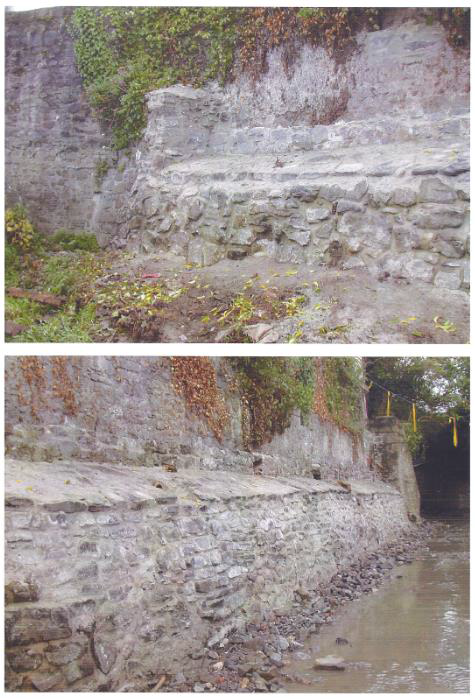
Five boreholes were dug for the purposed of installing groundwater monitoring wells as requested by the EPA, three to the south of the River Breagagh, and two to the north (Appendix 1). The boreholes involved hand-digging an inspection pit of 0.5m x 0.5m to a depth of 1m and then drilling a 100mm casing containing a plastic sleeve to depths of 6-8m. In four of the five boreholes, natural was reached between 1.8-2m below bgl. In borehole A (BHA) to the north of the river, natural was reached at 3.4m below bgl. In all of the boreholes the upper deposits were made up of modern fill including red brick, slate and mortar and nothing of archaeological interest was noted.
Detailed Results of Groundwater Monitoring Boreholes
| BHA | Dimensions: 100mm diameter | |
| Depth | Description | Interpretation |
| 0.0m-0.2m | Re-enforced concrete. | Modern surface. |
| 0.2-0.6m | Cobbles and sandy gravel with inclusions of red brick and occasional slate. | Modern fill. |
| 0.6-1.25m | Brown grey gravelly sand with inclusions of slate, red brick, mortar, glass, plastic and charcoal. | Modern fill. |
| 1.25-1.4m | Dark brown grey silty clay with inclusions of mortar and wood fragments. | Modern fill. |
| 1.4-1.65m | Mid-dark brown grey silty clay with inclusions of mortar and wood fragments. | Modern fill. |
| 1.65-2.4m | Brown-grey loose silty sandy coarse gravel with frequent stones, red brick fragments and mortar. | Modern fill. |
| 2.4-2.6m | Dark brown black organic clayey silt with bits of wood and red brick, within coarse gravel. | Modern fill. |
| 2.6-3.4m | Brown grey coarse gravelly sand with some stones, mortar and burnt bone. | Modern fill. |
| 3.4-4.0m | Yellow grey coarse gravel. | Natural |
| 4.0-4.25m | Yellow grey fine gravel and sand. | Natural |
| 4.25-4.4m | Fine grey sand. | Natural |
| 4.4-4.9m | Medium coarse grey sand. | Natural |
| 4.9-6.0m | Brown-grey medium sand. | Natural |
| BHB | Dimensions: 100mm diameter | |
| Depth | Description | Interpretation |
| 0.0m-0.3m | Re-enforced concrete. | Modern surface. |
| 0.3-0.9m | Brown medium sand and cobbles. | Modern fill. |
| 0.9-1.0m | Dark grey coarse sand with inclusions of red brick fragments and a mix of rounded cobbles and angular stones, average diameter 6-7cms. | Modern fill. |
| 1.0-1.4m | Mixed stony material with inclusions of mortar, red brick and gravel. | Modern fill. |
| 1.4-1.8m | Fine grey sandy clay, with inclusions of mortar & occasional charcoal. | Modern fill. |
| 1.8-2.0m | Fine yellow silty sand. | Natural. |
| 2-3m | Brown silty clay with stones, changes to light grey sandy gravel and then to medium grey sand with decomposed organic matter and snail shells and finally to mid grey stones and fine sand close to 3m. | Natural. |
| 3-4m | Yellow grey gravel, sandier in the last 20cms. | Natural. |
| 4-5m | Fine grey gravel, sandier towards 5m. | Natural. |
| 5-6m | Coarse grey sand to around 5.2m and then stony gravel to 6m. | Natural. |
| 6-7m | Light brown sandy gravel, changing to fine light brown sand from 6.35m. | Natural. |
| 7-8m | Fine light brown sand. | Natural. |
| BHC | Dimensions: 100mm diameter | |
| Depth | Description | Interpretation |
| 0.0m-0.2m | Re-enforced concrete. | Modern surface. |
| 0.2-0.45m | Brown medium sand and cobbles. | Modern fill. |
| 0.45-1.0m | Mix of mid grey coarse sandy gravel with stones, red brick fragments and bits of mortar, slate and cinder. | Modern fill. |
| 1.0-1.4m | Mix of mortar, red brick, slate and gravel. | Modern fill. |
| 1.4-1.6m | Dark brown silty sandy clay with red brick, mortar and charcoal. | Modern fill. |
| 1.6-1.85m | Light grey brown silty sandy clay with some stones and flecks of mortar. | Modern fill. |
| 1.85-1.95m | Mid-grey silty sandy clay with inclusions of mortar and red brick. | Modern fill. |
| 1.95-2.9m | Light grey fine silty clay. | Natural. |
| 2.9-3.4m | Coarse stony gravel. | Natural. |
| 3.4-6.9m | Coarse gravelly sand with some fine gravel. Includes bands of grey and brown-yellow sandy gravel. | Natural. |
| 6.9-7m | Coarse mid-brown sand. | Natural. |
| BHD | Dimensions: 100mm diameter | Figure: Appendix 1 | |
| Depth | Description | Interpretation | Finds |
| 0.0m-0.2m | Re-enforced concrete. | Modern surface. | N/A |
| 0.2-0.55m | Grey brown, mix of mortar, stones and brown silty sand with flecks of red brick. | Modern fill. | None |
| 0.55-0.9m | Light grey sandy gravel with stones and occasional bits of red brick. | Modern fill. | None |
| 0.9-1.0m | Black silty clay with mortar & red brick inclusions. | Modern fill. | None |
| 1.0-1.5m | Black silty sand with frequent mortar & cinders. | Modern fill. | Modern pottery |
| 1.5-2.0m | Mid grey silty sand with frequent bits of mortar and red brick, roots and wood fragments, charcoal. | Modern fill. | Modern pottery |
| 2.0-2.1m | Light grey medium sand. | Natural | N/A |
| 2.1-2.9m | Mid grey silty clay, becoming yellow towards 2.9m. | Natural | N/A |
| 2.9-3.8m | Light grey sandy gravel. | Natural | N/A |
| 3.8-4.1m | Grey medium sand. | Natural | N/A |
| 4.1-5.0m | Mid grey coarse sand and gravel. | Natural | N/A |
| 5.0-5.2m | Yellow-grey gravel and sand with stones. | Natural | N/A |
| 5.2-6.0m | Brown medium sand. | Natural | N/A |
| BHE | Dimensions: 100mm diameter | |
| Depth | Description | Interpretation |
| 0.0m-0.25m | Re-enforced concrete. | Modern surface. |
| 0.25-0.7m | Coarse sand and gravel with rounded cobbles, inclusions of mortar & redbrick fragments. | Modern fill. |
| 0.7-0.9m | Concrete. | Modern fill. |
| 0.9-1.6m | Mixed grey brown coarse silty sand containing mortar, red brick and some stones. Layer of mortar within, at 1.3- 1.4m. | Modern fill. |
| 1.6-2.0m | Dark grey brown sandy silty clay with inclusions of cinder, mortar and decaying organics (twigs). | Modern fill. |
| 2.0-2.6m | Lighter grey sandy silty clay with some coarse gravel. | Natural. |
| 2.6-2.9m | Light yellow grey silty clay, occasional dark brown patches of decayed organics. | Natural. |
| 2.9-3.0m | Grey sandy silty gravel. | Natural. |
| 3.0-4.65m | Medium yellow-grey silty sandy finely coarse gravel with occasional cobbles. | Natural. |
| 4.65-5.6m | Fine medium grey sand. | Natural. |
| 5.6-6.0m | Brown grey silty sandy gravel. | Natural. |
| 6.0-7.0m | Grey brown medium sandy gravel with some cobbles. | Natural. |
| 7.0-7.6m | Mid brown grey slightly silty coarse gravelly sand. | Natural. |
| 7.6-8.0m | Fine brown grey silty sand. | Natural. |
Test Pits
|
TP01 (Test pit) |
Dimensions: 1m x 0.7m x 2.6m |
||
| Depth | Description | Interpretation | Finds |
| 0.0m-0.2m | Tarmac and hardcore | Modern surface | N/A |
| 0.2m-0.45m | Grey black gravel and sand | Modern made- up ground | None |
|
0.45m- 0.55m |
Deposit of dumped red brick fragments and mortar | Modern made- up ground | None |
| 0.55m-0.9m | Mid grey brown sandy clay | Modern made- up ground | None |
| 0.9m-1.35m | Grey silty clay with some inclusions of mortar and slate fragments | Modern made- up ground | None |
| 1.35m-2.5m | Very fine dark black-brown silty clay, inclusions of slate, red brick, animal bone |
Organic deposit, post medieval or later, possibly related to a flood event |
Pottery (Brownware) |
| 2.5m-2.6m | Fine brown silt | River deposit, possibly related to a flood event | None |
| 2.6m | Mid grey sandy gravel | Natural | None |
|
TP02 (Test pit) |
Dimensions: 1.5m x 0.7m x 1.5m |
||
| Depth | Description | Interpretation | Finds |
| 0.0-0.2m | Re-enforced concrete and hardcore. | Modern surface | N/A |
| 0.2m-0.7m | Loose light brown sand and gravel, occasional red brick fragments and flecks of mortar throughout. | Modern made- up ground | None |
| 0.7m-0.95m | Loose dark grey black sandy clay mixed with red brick and mortar. | Early modern made-up ground | None |
| 0.95m-1.5m | Dark brown mottled silty clay with flecks of mortar and red brick. At c.1m some large stones at the north end of the test pit may represent the face of a wall oriented roughly SW-NE. | Early modern made-up ground, possible stone wall | Modern pottery, glass |
|
TP03 (Test pit) |
Dimensions: 1.5m x 0.65m x 2.35m |
||
| 0.0m-0.2m | Re-enforced concrete and hardcore. | Modern surface | N/A |
| 0.2m-1m | Loose light brown sand and gravel, occasional red brick fragments. | Modern made- up ground, possibly river gravels | None |
| 1m-1.9m | Dark grey black silty clay, inclusions of red brick, slate and wood fragments. | Early modern made-up ground | Modern pottery, glass, oyster shell |
| 1.9m-2.35 | Fine grey silty clay | River silts | None |
|
TP04 (Test pit) |
Dimensions: 1m x 0.7m x 0.6m |
|
| Depth | Description | Interpretation |
| 0.0m-0.2m | Re-enforced concrete and hardcore. | Modern surface |
| 0.2m-0.4m | Loose light brown gravel and sand | Modern made-up ground |
| 0.4m-0.6m | Loose grey gravel and sand | Modern made-up ground |
| 0.6m | Concrete slab | Modern surface |
|
TP05 (Test pit) |
Dimensions: 1m x 0.7m x 2.25m |
||
| Depth | Description | Interpretation | Finds |
| 0.0m-0.5m | Re-enforced concrete and hardcore. | Modern surface | N/A |
| 0.5m-1.35m | Loose light brown gravel and sand. | Modern made- up ground | Modern pottery |
| 1.35m-1.8m | Loose dark brown silty clay with frequent inclusions of mortar and red brick. | Modern made- up ground | Modern pottery, animal bone |
| 1.8m-2.3m | Mid-dark grey silty gritty clay with frequent inclusions of red brick fragments and mortar. | Modern made- up ground | Modern pottery |
| 2.3m-2.55m | Grey gravel | Natural | None |
|
TP06 (Test pit) |
Dimensions: 1.5m x 0.7m x 2.25m |
||
| Depth | Description | Interpretation | Finds |
| 0.0m-0.2m | Re-enforced concrete and hardcore. | Modern surface | N/A |
| 0.2m-1.35m | Loose light brown gravel and sand, inclusions of mortar, red and yellow brick, slate and plastic. | Modern made- up ground | Modern pottery |
|
1.35m- 1.95m |
Mid-dark brown silty clay with flecks of mortar and red brick. | Modern made- up ground | None |
|
1.95m- 2.25m |
Fine dark grey silty clay |
Post medieval or later, possibly related to a flood event |
Pottery (Brownware) and clay pipe stem fragments (x2) |
|
TP07 (Test pit) |
Dimensions: 1.5m x 0.7m x 0.65m |
|
| Depth | Description | Interpretation |
| 0.0m-0.25m | Re-enforced concrete and hardcore. | Modern surface |
|
0.25m- 0.65m |
Loose mid brown gravel and sand | Modern made-up ground |
| 0.65m | Concrete slab | Modern surface |
|
TP08 (Test pit) |
Dimensions: 1m x 0.7m x 2.4m |
||
| Depth | Description | Interpretation | Finds |
| 0.0m-0.25m | Re-enforced concrete and hardcore. | Modern surface | N/A |
| 0.25m-1.1m |
Mid brown rubble material with lots of mortar, yellow and red brick, slate fragments Loose light brown gravel and sand, inclusions of mortar, red and yellow brick, slate and plastic. |
Modern made- up ground |
Early modern white glazed yellow brick (stamped “J & M Craig Kilmarnock Scotland) dates to early 19th-early 20th Century. |
| 1.1m-2.2m | Dark brown silty clay with lumps and flecks of mortar and animal bone. | Modern made- up ground | Modern glass bottle |
| 2.2m-2.4m | Grey brown sandy clay. | Natural | None |
|
TP09 (Test pit) |
Dimensions: 1.5m x 0.7m x 2.4m |
||
| Depth | Description | Interpretation | Finds |
| 0.0m-0.25m | Re-enforced concrete and hardcore. | Modern surface | N/A |
| 0.25m-0.4m | Black loose gravel. | Modern made- up ground | None |
| 0.4m-1.2m | Loose mid brown gravel and sand, inclusions of mortar, red brick, slate and plastic. | Modern made- up ground | Modern pottery |
| 1.2m-2.4m | Dark brown sandy clay with bits of mortar and red brick, slate, plastic, re-bar, wire, animal bone. | Modern made- up ground, dumped rubbish | Bead (probably modern), modern glass |
|
TP10 (Test pit) |
Dimensions: 1.9m x 0.6m x 2.2m |
||
| Depth | Description | Interpretation | Finds |
| 0.0m-0.3m | Re-enforced concrete and hardcore. | Modern surface | N/A |
| 0.3m-0.8m | Loose mid brown sand and gravel, inclusions of mortar flecks. | Modern made- up ground | Modern pottery |
| 0.8m-1.8m | Loose dark brown sandy silt, flecks and lumps of mortar. | Modern made- up ground | None |
| 1.8m-2.2m | Mid grey silty clay, inclusions of animal bone, burnt bone and flecks of charcoal. | Mid grey silty clay, inclusions of animal bone, burnt bone and flecks of charcoal. | None |
|
TP CB (Test pit) |
Dimensions: 2m x 4m x 3.1m |
||
| Depth | Description | Interpretation | Finds |
| 0.0m-0.5m | Re-enforced concrete and gravel. | Modern surface | N/A |
| 0.5m-1.1m | Loose mid brown sand, gravel and water rolled stones. | Modern made- up ground | None |
| 1.1m-1.8m | Grey gravelly sandy silt, red brick and mortar fragments. | Modern made- up ground | None |
| 1.8m-2m | Dark brown organic peaty material with inclusions of oyster shell, animal bone, glass and red brick fragments. | Early modern occupation layer | Glass, red brick fragments |
| 2m-2.8m | Stony grey black silty grey clay with mussel shell inclusions. | River silts related to a flood event, possible archaeological layer. | None |
| 2.8m-3.1m | Dark brown-black soft clayey silt with inclusions of seashell, animal bone and charcoal. | Possibly an archaeological layer / river silts related to a flood event. | None |
| 3.1m | Grey sandy gravel | Natural | N/A |
Appendix C Archaeological Investigations within and adjacent to the Masterplan area - Adjacent to the Masterplan
| Licence No | KKAP Ref | Description | Archaeologist | Location | Date |
| 03E1901 | KKAP-022 | Excavation of Vicar's Choral building of St. Canice's cathedral. Post-medieval wall. | Emmet Stafford, Catherine McLoughlin | 15-16 Vicar Street | 2004 |
| KKAP-023 | Testing of Vicar's choral building | John Tierney | 15-16 Vicar's street | 2003 | |
| 97E0481 | KKAP-154 | Kilkenny Main Drainage Battered medieval wall at Mill Lane, organic possible Early Medieval deposits at St. Canice's place and culverted mill-race at Parliament Street | Patrick J. H Neary | Mill Lane, St Canice’s Place | 1997-1999 |
| KKAP-175 | Industrial mill and weir complex including 17th century rectangular mill-building, mill-race and waterwheel pit. Late 17th century 'deflection dam' and wattle panelling. Extensive remodeling occurred after the 1763 flood | Paul Stevens and Brenda O’Meara |
NOR-2, NOR-4 The Mill Island and Green's Bridge Weir (Part of Green's Bridge Mills) |
2001-2002 | |
| 00E0170 | KKAP-026 | Four walls and remains of cobbled surface of post- medieval date. Medieval deposits beneath stone building and cobbles. | Mary Henry | 19 Vicar Street | 2000 |
| 04E0615 | KKAP-131 | Architectural recording of a 'free-standing arch' for Watergate bridge | Kevin Lohan | Irishtown Bridge | 2004 |
| 95E0062 | KKAP-155 | Reclamation deposits overlying medieval organic material | Margaret Gowen | Kytler's Inn, 25-26 St Kieran’s Street | 1995 |
| 00E0027 | KKAP-041 | Archaeological excavation was undertaken to facilitate the construction of manholes for the Kilkenny Main Drainage scheme. Seven stratigraphic layers were identified, all of which were archaeologically sterile. A stone flag floor, associated with a Georgian house, was identified at a depth of 2m below the current ground surface. | Emer Dennehy | 33 Parliament Street | 2000 |
| 06E1190 | KKAP-045 | Interior of Tudor house, mortar and brick layers | Sheila Lane | 38 Parliament Street | 2006 |
| 00E0128 | KKAP-046 | Build level of Tudor house and medieval deposits | Paul Stevens | 39 Parliament Street | 2000 |
| 99E0713 | KKAP-124 | Organic reclamation deposits of possible medieval date. Post-medieval deposits | Mary Henry | Green Street | 1999 |
| 04E1618 | KKAP-223 | No finds or features of an archaeological nature were noted in testing | Sheila Lane | Winston‘s Department Store | 2004 |
| 00E0406 | KKAP-076 | Late Medieval timber structure, timber bridge foundations, medieval wall | Paul Stevens | BRE-6 Banks of the river Breagagh Gardens Townland | 2000 |
| 98E0167 | KKAP-009 | Medieval Housing and Reclamation | Hilary Opie | 1-13 Kieran Street | 1998 |
| 97E0334 | KKAP-010 | Medieval Housing and Reclamation | Ruairi O’Baoill | 10-13 Kieran Street | 1997 |
| 07E0549 | - | Five test trenches revealed a burial, a number of medieval deposits, a well and post medieval wall | Maedbh Saunderson | Courthouse test excavation | 2007 |
| 08E0462 | - | Excavation revealed over 1000 contexts, 200 excavated features, 4000 sherds of medieval pottery, 2000 sherds of post-medieval pottery. Almost 500 pieces of well- preserved wood consisting of stakes, timbers, artefacts. Medieval domestic activity included wood lined cesspits and burgage plots. 23 burial (probable felons)were revealed from the prison context of the site | Maedbh Saunderson | Courthouse excavation | 2007 |
| Investigation within the Masterplan Area | |||||
| Licence No | KKAP Ref | Description | Archaeologist | Location | Year |
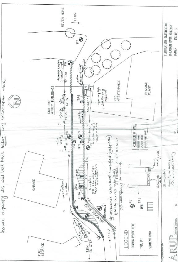
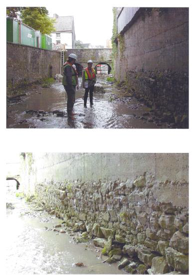
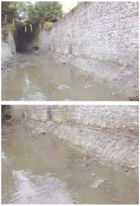
| 99E0385 | KKAP-190 | Archaeological test-excavations and monitoring was undertaken on the Breagagh river where it passes through St. Francis' friary. The works formed part of an assessment that was undertaken in advance of the removal of the river bed due to PCB contamination. Test pit No 4 yielded 2 sherds of medieval pottery | Margaret Gowen, Paul Stevens | River Breagagh at St. Francis' Abbey Brewery | 1999 |
| 95E0242 | KKAP-198 | Reclamation with decayed timbers | Margaret Gowen | St Francis’ Abbey Brewery | 1995 |
| 98E0069 | KKAP-204 | Test-excavations were undertaken in advance of the construction of a small extension to the fermentor block of the brewery in St. Francis' Abbey. Nothing of archaeological interest was noted | Margaret Gowen | St Francis’ Abbey Brewery | 1998 |
| 04E0694 | KKAP-203 | Reclamation and the possible residual remains, in the form of limestone building rubble, of the 18th-century horse barracks. | Kevin Lohan | St Francis’ Abbey Brewery | 2004 |
| 04E0694 | KKAP-205 | 19th and 20th reclamation | Brenda O‘Meara | St Francis’ Abbey Brewery | 2004 |
| 97E0099 | KKAP-206 | A single test-pit was excavated prior to the redevelopment of a fermentor block. A hard, compact, yellow boulder clay was identified 2.57m below existing ground level. This was sealed by a black organic silty clay, 1.32m deep. The uppermost 1.25m of fill consisted of demolition rubble, hard-core and thick concrete slab. | Edmond O'Donovan | St Francis’ Abbey Brewery | 1997 |
| 99E0148 | KKAP-207 | An organic silt, possibly a medieval reclamation layer, was discovered at the base of the excavated cutting, 2.50m. Two layers of post-medieval build-up were also recorded. | Edmond O'Donovan | St Francis’ Abbey Brewery | 1999 |
| - | KKAP-184 | Part of cloister and north transept of St. Francis' friary | Marcus O'hEochaidhe | St Francis’ Abbey Brewery | 1963 |
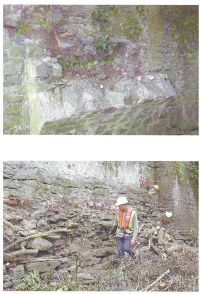
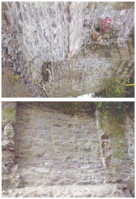
| KKAP-130 | Monitoring of river-gravel extraction revealed a sword fragment. A survey of the Town Wall and Evan's tower was also undertaken | Ian W. Doyle | Diageo Complex, River Breagagh |
2001 01E0632 |
|
| 07E1061 | - | Six test trenches were excavated and two walls were revealed in Trench 1, wall revealed at 43.1m OD (0.6mbgl) and Trench 4, wall revealed 42.55m OD (1.7m bgl) | Niklagh Gilligan | Diageo Complex | 2008 |
| 01E0303 | KKAP-209 | Stone jetty and timber platform | Niall Brady | NOR-10 Bateman Quay | 2001 |
| 01E0554 | KKAP-177 | 18th century stone jetty, private mooring, river wall | Paul Stevens | NOR-9 Bateman Quay | 2001 |
| 01E0555 | KKAP-080 | Excavation and full building survey of a semi-circular riverside revetment wall and associated early modern Pleasure House | Paul Stevens | NOR-6 Bateman Quay | 2001-2002 |
| 01E1166 | KKAP-079 | Series of post-medieval, parallel riverside walls and the truncated remains of a 'pleasure house' | Paul Stevens | Bateman Quay | 2002 |
| 10E323 | - | Underwater investigation did not reveal any archaeological features | ADCO | KCAS | 2010 |
| unknown | - | Six test trenches were excavated and four revealed archaeology relating to 18th-19th century building material/ structures | Colm Flynn | KCAS | 2012 |
| unknown | - | Identification of 2 stone walls thought to be 18th-19th in date and part of a structure. | Colm Flynn | Diageo complex – Visitor Attraction Project | 2014 |
| 14E0250 | - | A series of 19th and 20th century walls, box drains and culverts were uncovered, which tie into Rocque’s map of 1758. The outfall area was previously disturbed, a possible riverine deposit (a dark grey brow silt) was detected below c.1.5m | Gill McLoughlin | Diageo complex - monitoring an underground ESB cable and outfall upgrade | 2014 |
| 13E0270 | - | 18 window samples, 8 boreholes, 11 test pits and a programme of river bank sampling | Gill McLoughlin and Mark Moraghan | Monitoring of geotechnical test pits and boreholes | 2013-2014 |
| Ministerial Consent (C607) | - | Stone revetment wall to the east of Evan’s Tower was revealed for a length of 1.6m, depth of 1.1m and was oriented northwest-southeast (5 courses were uncovered). | Gill McLoughlin | Monitoring on the banks of the river Nore | 2014 |
|
NIAH Reg No. |
Address | Date | Categories of special Interest | Rating | Original Use | Description | Coordinates | Photo |
|
12004007 |
Green's Bridge |
1765 - 1770 |
Architectural Technical | National | Bridge | Five-arch rubble limestone Classical-style road bridge over river. Built 1766 by William Colles (c.1710-70) to designs prepared by George Smith (fl. 1763-7) after the Roman Bridge at Rimin. Finely-carved limestone dressings exhibiting high quality stone masonry. The graceful profile of the arches identifies the civil engineering heritage significance of the site. |
250558, 156536 |
 |
|
12003050 |
Hillman Humber and Commer, Green Street |
1940 - 1960 |
Architectural | Regional | Garage | Detached four-bay two-storey gable-fronted garage, c.1950. Pitched (gable-fronted) roof behind parapet with cast-iron rainwater goods. Painted rendered walls with channelling to ground floor. Square-headed openings with fixed-pane windows. |
250399, 156511 |
 |
|
12003025 |
Vicar Street |
1890 - 1910 |
Artistic Technical | Regional | Vent Pipe | A vent pipe of significance for the associations with a sewage system developed in Kilkennyc.1900. Raised elements together with a profiled parapet indicate the equal importance placed on aesthetic effects as well as functionality. |
250375, 156460 |
|
|
12000002 |
19 Vicar Street |
1840 - 1860 |
Architectural | Regional | House | End-of-terrace three-bay two-storey house, c.1850. Pitched slate roofs with clay ridge tiles, rendered chimney stacks, and cast-iron rainwater goods on rendered eaves. Square- headed window openings with cut-stone sills and moulded rendered surrounds. Renovated, c.1950, however retaining the original composition attributes elsewhere together with substantial quantities of the historic fabric the house continues to make a pleasing impression in an historic streetscape. |
250420, 156386 |
|
|
12000001 |
24 Vicar Street |
1900 - 1910 |
Architectural | Regional | House |
Attached two-bay two-storey house, built 1905, with two-bay two-storey return to east. Hipped slate roof with terracotta ridge tiles. Painted rendered, ruled and lined walls with rendered vermiculated quoins to ends. A pleasant small-scale house distinguished in the streetscape on account of attributes including camber-headed openings with one incorporating an elegant bipartite arrangement, subtle decorative render detailing, and so on, all of which enhance the architectural design value of the composition. |
250402, 156379 |
 |
|
12000258 |
20 Vicar Street |
1890 - 1910 |
Architectural | Local | House | End-of-terrace three-bay two-storey house, c.1900, possibly originally two separate single- bay two-storey houses incorporating fabric of earlier house, pre-1840, on site. Hipped and pitched slate roof with clay ridge tiles. Square- headed window openings and door opening with moulded rendered surround. Interior with remains of timber panelled reveals/shutters to window openings. Road fronted with concrete footpath to front. |
250427, 156371 |
 |
|
12000003 |
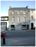
D. Walsh, Saint Canice's Place |
1790 - 1810 |
Architectural | Regional | House |
Terraced three-bay three-storey house, c.1800. Pitched slate roof with clay ridge tiles. Square- headed window openings with cut-stone sills. Ground floor remodelled, c.1975. Road fronted with concrete footpath to front. A well- appointed substantial house incorporating Classically-derived proportions with the diminishing in scale of the openings on each level lending an elegant formal quality to the street scene. The survival of the original composition attributes to the upper floors together with most of the early fabric significantly enhances the contribution the site makes to the character of the streetscape. |
250410, 156317 |
 |
|
12000004 |
Phil Treacy, 11 Irishtown |
1840 - 1860 |
Architectural | Regional | House | A well-composed Classically-proportioned substantial house lending a formal quality to the streetscape. Terraced three-bay three- storey house, c.1850, possibly originally with shopfront to ground floor. Pitched (shared) slate roof with decorative terracotta ridge tiles. Painted rendered. Square-headed window openings and square-headed door opening with timber panelled door having overlight. Road fronted with concrete footpath to front. The original form of the upper floors survives substantially intact together with much of the early fabric both to the exterior and to the interior, thereby significantly enhancing the character of the site. |
250413, 156310 |
 |
|
12000005 |
Phil Treacy, 12 Irishtown |
1840 - 1860 |
Architectural | Regional | House |
Terraced three-bay three-storey house, c.1850, possibly originally with shopfront to ground floor. Pitched (shared) slate roof with decorative terracotta ridge tiles. Square- headed window openings with cut-stone sills, moulded rendered surrounds, and one-over- one timber sash windows. Square-headed openings to ground floor remodelled, c.1950, with fixed-pane timber window to left ground floor, and glazed timber panelled double doors to right ground floor having fascia over. Interior with timber panelled shutters to window openings. Road fronted with concrete footpath to front. |
250416, 156301 |
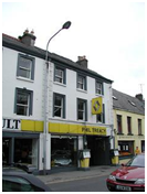 |
|
12000006 |
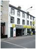
Antique Clique (The), 16 Irishtown |
1840 - 1860 |
Architectural Artistic | Regional | House | Terraced three-bay two-storey house, c.1850. Pitched slate roof with clay ridge tiles, painted rendered walls and square-headed window openings. Timber shopfront, c.1900, to ground floor with pilasters, fixed-pane timber windows, timber panelled door, glazed timber panelled door to house, and fascia over having moulded cornice. Road fronted with concrete footpath to front. A modest-scale house retaining most of the historic composition attributes together with substantial quantities of the early fabric including a fine shopfront of artistic design merit displaying good quality craftsmanship while maximising on the streetscape presence of the site at street level. |
250426, 156278 |
 |
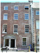
|
12000007 |
Irishtown Bridge, Irishtown, Watergate |
1565 - 1570 |
Archaeological Technical | National | Bridge |
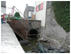
Two-arch rubble stone bridge widened in 1759 after reconstructed in 1568. Incorporating fabric of earlier bridge, 1352. A bridge has existed on site since 1207 with the early provenance serving to identify the archaeological significance of the site. Meanwhile the traditional construction in unrefined rubble stone produces an appealing, if subtle textured visual effect in the street scene. |
250438, 156254 |
 |
|
12000099 |
James Hughes, 31 Parliament Street |
1890 - 1910 |
Architectural | Regional | House | An appealing modest-scale building possibly originally built as two separate houses successfully navigating an important corner site through the use of a chamfered side elevation. Detached four-bay two-storey house, c.1900, on a corner site probably originally two separate two-bay two-storey houses with two- bay two-storey chamfered side (north-west) elevation. Renovated, c.1925. Pitched slate roofs with clay ridge tiles, painted rendered walls and square-headed window openings. Square-headed openings to ground floor remodelled, c.1925. Road fronted on a corner site with concrete footpath to front. |
250468, 156223 |
|
|
12000097 |
Kilkenny Tourist Hostel, 35 Parliament Street |
1815 - 1835 |
Architectural | Regional | House | An attractive middle-size range built as an extension to the house adjacent to south (12000096) incorporating Classically-derived proportions, thereby contributing to the formal quality of Parliament Street. End-of-terrace two-bay three-storey over basement house, c.1825, built as extension to house to south. Reroofed c.1925. Pitched roof with replacement artificial slate, painted rendered walls and square-headed window openings with six-over- six (first floor) and three-over-three (top floor) timber sash windows. Road fronted with sections of wrought iron railings to front on unpainted rendered parapet having cut- limestone coping. |
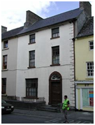
250483, 156186 |
 |
|
12000096 |
Kilkenny Tourist Hostel, 35 Parliament Street, Kilkenny, County Kilkenny |
1765 - 1785 |
Architectural | Regional | House | An attractive middle-size house built as one of a pair (with 12000095) incorporating Classically-derived proportions, thereby contributing to the formal quality of Parliament Street. Terraced two-bay three-storey over basement house, c.1775, originally end-of- terrace. Pitched slate roof with clay ridge tiles. Painted rendered walls, square-headed window openings with six-over-six (first floor) and three-over-three (top floor) timber sash windows. Round-headed door. Road fronted with sections of wrought iron railings to front on limestone ashlar parapet having cut- limestone coping. |
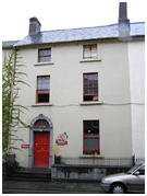
250490, 156182 |
 |
|
12000095 |
36 Parliament Street |
1765 - 1785 |
Architectural Historical Social | Regional | House |
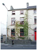
An attractive middle-size house built as one of a pair (with 12000096) incorporating Classically-derived proportions, thereby contributing to the formal quality of Parliament Street. The retention of much of the early fabric both to the exterior and to the interior further enhances the contribution the house makes to the historic quality of the streetscape. The house remains of additional importance for the historic use as a Royal Irish Constabulary Barracks during the War of Independence (1919-21). Terraced two-bay three-storey over basement house, c.1775. Renovated, c.1825. Pitched roof with replacement slate. Painted rendered walls with rendered quoins. Square-headed windows with six-over-six (first floor) and three-over-three (top floor) timber sash windows. Round-headed door opening. Road fronted with sections of wrought iron railings to front on limestone ashlar parapet having cut-limestone coping. |
250494, 156174 |
 |
|
12000094 |
McGrath, 37 Parliament Street |
1765 - 1785 |
Architectural Artistic | Regional | House | A pleasant house of modest character possibly originally built as a smaller composition as suggested by the variance in the proportions of the openings in the upper floors together with some discrepancies in the treatment of the wall surface: the resulting tiered effect produced by the stepping-in of the openings presents a distinctive quality in the street scene. Terraced three-bay three-storey house, c.1775, possibly originally three-bay two-storey. Reroofed, c.1925, possibly with top floor added. Painted rendered walls. Square-headed window openings with six-over-six (first floor) and two- over-two (top floor) timber sash windows. Timber shopfront, c.1900. Road fronted with concrete footpath to front. |
250492, 156166 |
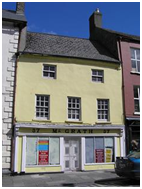 |
|
12000093 |
Ristorante Da Pino/James Harte and Son, 38 Parliament Street |
1715 - 1735 |
Architectural Archaeological | Regional | House |
A well-appointed middle-size house originally forming part of a larger composition with the range adjacent to south (12000092) representing the continuation of a long- standing presence on site: incorporating substantial portions of the late sixteenth- century Red Lion Inn the house forms an important element of the archaeological heritage of Kilkenny. Terraced two-bay three- storey over basement house, c.1725, originally forming part of larger five-bay three-storey house with building to south with single-bay three-storey return to east incorporating fabric of medieval inn, c.1575, having two-bay single- storey range to east. Renovated, c.1850. Reroofed, c.1950. Painted rendered walls to front (west) elevation with exposed random rubble stone walls to remainder. Square- headed window openings to front (west) elevation with cut-stone sills with chamfered reveals, chamfered mullions, and hood mouldings. Timber shopfront to ground floor. Road fronted with concrete footpath to front. |
250501, 156162 |
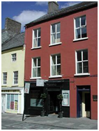 |
|
12000092 |
James Harte and Son, 39 Parliament Street |
1715 - 1735 |
Architectural Archaeological | Regional | House |
A well-appointed middle-size house originally forming part of a larger composition with the range adjacent to north (12000093) representing the continuation of a long- standing presence on site: incorporating substantial portions of the late sixteenth- century Red Lion Inn the house forms an important element of the archaeological heritage of Kilkenny. Terraced three-bay three- storey over basement house, c.1725, originally forming part of larger five-bay three-storey house c.1575, Renovated, c.1850. Reroofed, c.1950. Pitched (shared) roofs with replacement artificial slate, c.1950. Painted rendered wall to front (west) elevation with exposed random rubble stone walls to remainder. Square-headed window openings to return and to range to east with cut-stone surrounds having chamfered reveals, chamfered mullions, hood mouldings over, and replacement timber casement windows. Square-headed door opening with timber panelled door having overlight. Road fronted with concrete footpath to front. |
250499, 156155 |
 |
|
12000091 |
Sherry Fitzgerald McCreery, 40 Parliament Street, |
1790 - 1810 |
Architectural Artistic | Regional | House |
An elegantly-composed substantial house built as one of a pair (with 12000090) incorporating Classically-derived proportions enhancing the formal quality of the streetscape of Parliament Street. Exhibiting high quality stone masonry a finely-carved doorcase accommodating two door openings (a characteristic of Kilkenny) and further enlivens the external expression of the composition. The house potentially represents an important element of the archaeological legacy of Kilkenny City. Terraced two-bay four-storey over basement red brick house. Pitched (shared) slate roof behind parapet. Red brick Flemish bond walls with square-headed window openings with cut-stone sills, red brick voussoirs, six-over-one (first floor), three-over-six (second floor) and three- over-three (top floor) timber sash windows. Square-headed door opening in shared elliptical-headed doorcase with three cut- limestone steps, cut-limestone engaged Tuscan columns supporting frieze, timber panelled door, and shared fanlight having cut-limestone archivolt. Interior with entrance hall having carved timber architraves to door openings with timber panelled doors, plasterwork cornice to ceiling having decorative plasterwork rosette, and timber panelled shutters to window openings. Road fronted with sections of wrought iron railings to front on rendered plinth having cut-limestone coping. |
250507, 156152 |
 |
|
12000090 |
Michael Buggy, 41 Parliament Street, |
1790 - 1810 |
Architectural Artistic | Regional | House |
An elegantly-composed substantial house built as one of a pair (with 12000091). Terraced two-bay four-storey over basement red brick house, c.1800, with single-bay four-storey return to east. Pitched (shared) slate roof behind parapet. Red brick Flemish bond walls. Square-headed window openings with six-over- one (first floor), three-over-six (second floor) and three-over-three (top floor) timber sash windows. Square-headed door opening (shared with 12000091). Interior with entrance hall having carved timber architraves to door openings with timber panelled doors, plasterwork cornice to ceiling having decorative plasterwork rosette, round-headed door opening to stair hall having fanlight, carved timber staircase, and timber panelled shutters to window openings. Road fronted with sections of wrought iron railings to front on rendered plinth having cut-limestone coping. |
250506, 156145 |
 |
|
12000089 |
Kilkenny County Enterprise Board, 42 Parliament Street, |
1765 - 1785 |
Architectural | Regional | House |
A well-composed substantial house built as one of a pair (with 12000088) incorporating Classically-derived proportions with the resulting diminishing in scale of the openings on each floor enhancing the elegant formal quality of the streetscape. Terraced three-bay three-storey over basement red brick house, c.1775. Pitched (shared) slate roof with clay ridge tiles. Red brick Flemish bond walls with cut-limestone chamfered, quoins to ends. Square-headed window openings with cut-stone sills, six-over-six and three-over-three (top floor) timber sash windows. Round-headed door opening with Gibbsian surround. Road fronted with sections of wrought iron railings to front on cut- limestone plinth. |
250511, 156140 |
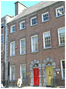 |
|
12000088 |
Smithwick, 43 Parliament Street |
1765 - 1785 |
Architectural | Regional | House | A well-composed substantial house built as one of a pair (with 12000089) incorporating Classically-derived proportions with the resulting diminishing in scale of the openings on each floor enhancing the elegant formal quality of the streetscape of Parliament Street. Terraced three-bay three-storey over basement red brick house, c.1775, with single-bay three- storey recessed end bay to right having round- headed carriageway to ground floor. Pitched slate roofs (shared to main block) with clay ridge tiles. Red brick Flemish bond walls with cut-limestone dressings. Square-headed window openings with replacement one-over- one timber sash windows, c.1900, on ground floor. Round-headed door opening with Gibbsian surround. Road fronted with sections of wrought iron railings to front on cut- limestone plinth. |
250514, 156133 |
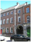 |
|
12000086 |
Jenkin's Lane |
1865 - 1885 |
Architectural | Regional | Cobbles/ Flags/Pa ving/Kerbing | Section of limestone cobbling, c.1875, with cut- limestone flagged wheel tracks. An appealing, if subtle feature in the street scene representing a traditional method of paving using locally-sourced materials: the resulting pattern displays a pleasant character lacking in the modern coverings applied to roads and streets. |
250532, 156145 |
|
|
12000087 |
E. Smithwick and Sons Limited, Jenkin's Lane |
1865 - 1885 |
Architectural Artistic | Regional | Gates/Ra ilings/Walls |
A robustly-detailed gateway c.1875, forming a picturesque feature in the streetscape of Jenkin's Lane: decorative accents with particular emphasis on the Classically-derived rendered dressings contribute significantly to the artistic design value of the composition while exhibiting high quality craftsmanship. Comprising segmental-headed carriageway with pair of painted rusticated rendered piers and timber double doors. Lane fronted |
250542, 156146 |
|
|
12000085 |
Saint Francis's Abbey Brewery, 44 Parliament Street |
1880 - 1885 |
Architectural | Regional | Office | Attached four-bay three-storey office building, built 1882. A well-composed middle-size building making a distinctive impression in the streetscape of Parliament Street on account of the variety of materials employed in the construction representing a characteristic of the late nineteenth-century High Victorian period: the resulting combination of limestone with red, yellow and vitrified blue brick produces an appealing polychromatic visual effect enhancing the architectural design importance of the composition. Finely-carved details displaying high quality stone masonry in locally-sourced County Kilkenny limestone further enliven the external expression of the building while the retention of substantial quantities of the early fabric ensures that the site contributes positively to the historic character of the street scene. |
250532, 156129 |
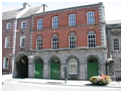 |
|
12000084 |
Kilkenny City Courthouse, Parliament Street |
1790 - 1795 |
Architectural Artistic Archaeological Historical Social | National | Court House |
An edifice of national significance in the architectural heritage of Kilkenny occupying a site having origins in the thirteenth-century Grace's Castle reputedly surviving to the present day in fragments in the basement level. Subsequently yielded by James Grace (n. d.) for adaptation to use as a bridewell or gaol the building represents one of the earliest- surviving civic institutions in the locality. Converted to use as a courthouse possibly to designs prepared by Sir Jerome Fitzpatrick (n. d.) with an internal configuration highlighting the prevailing influence of James Gandon's (1743-1823) contemporary (1784) Waterford City Courthouse (demolished pre-1849) the composition as it appears today is primarily the product of a comprehensive redevelopment in the early nineteenth century to designs prepared by William Robertson (1770-1850): the resulting Classical scheme surmounting a somewhat haphazard base forms an elegantly distinctive focal point in the centre of Parliament Street. |
250547, 156112 |
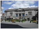 |
|
12000236 |
Parliament Street |
1881 - 1901 |
Artistic Historical Social | Regional | Post Box | Freestanding cast-iron pillar post box, between 1881-1901, with raised "VR" royal cipher, moulded necking, and shallow domed capping. Road fronted on concrete brick cobbled footpath. |
250521, 156098 |
No Image |
|
12000083 |
M.J. Crotty and Sons, 45 Parliament Street |
1815 - 1835 |
Architectural Artistic | Regional | House |
A well-appointed substantial house forming an important element of an assemblage of formal Classical quality in the street scene of Parliament Street while serving to frame the adjacent Kilkenny City Courthouse (12000084). Attached two-bay three-storey over basement house, c.1825, on an L-shaped plan with single-bay three-storey return to east. Extensively renovated, c.1875. Pitched slate roof with clay ridge tile. Unpainted rendered walls, square-headed window openings with cut-stone sills. Rendered shopfront, c.1875. Interior with timber panelled shutters to window openings. Road fronted with concrete brick cobbled footpath to front. |
250539, 156083 |
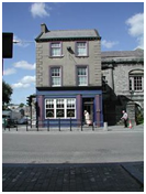 |
|
12000082 |
Parliament Street, |
1860 - 1865 |
Architectural Artistic Historical Social | Regional | Gates/Ra ilings/Walls | Remains of gateway, dated 1862-3, comprising pair of engaged rock-faced limestone ashlar outer piers with moulded course to plinth, limestone ashlar quoins to corners, cut-stone date stone/plaques, moulding supporting inscribed friezes, and moulded capping having blocking course. The attendant site remains of additional importance in the locality for the historic associations with the Confederation of Kilkenny (1642) together with the connections with Eamon De Valera (1882-1975). |
250535, 156077 |
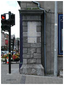 |
|
12000113 |
Daniel W. Bollard, 31-32 Saint Kieran's Street |
1920 - 1930 |
Architectural Artistic | Regional | House | A well-appointed substantial building forming an attractive component of the streetscape of Saint Kieran's Street identified by features including bipartite window openings recalling the so-called "Kilkenny Window", elegant decorative rendered accents, and so on all of which enhance the architectural design value of the composition. Terraced three-bay two-storey over basement house with dormer attic, built 1925, with pubfront to ground floor. Pitched roof, painted rendered walls and s quare-headed window openings. Pubfront to ground floor renovated on a symmetrical plan. Interior with timber panelled shutters to window openings. Road fronted. |
250569, 156032 |
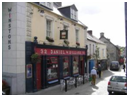 |
|
12000114 |
29 Saint Kieran's Street |
1840 - 1860 |
Architectural | Regional | House | An appealing house of modest architectural aspirations contributing positively to the visual appeal of the streetscape. Terraced two-bay two-storey house with dormer attic, c.1850, possibly incorporating fabric of earlier range, c.1600, on site. Pitched roof and painted rendered walls with square-headed windows and door. Remodelled, c.1900. Road fronted. |
250568, 156020 |
|
|
12000115 |
Lorimat, 28 Saint Kieran's Street, Kilkenny, County Kilkenny |
1765 - 1785 |
Architectural Archaeological | Regional | House |
A pleasant small-scale house incorporating the fabric of a late sixteenth- or early seventeenth- century range on site as manifested by a window reputedly surviving in a gable wall, therefore representing an important element of the archaeological heritage of Kilkenny. End-of- terrace two-bay two-storey house with dormer attic, c.1775, probably originally terraced. Extensively renovated, c.1900. Road fronted. |
250570, 156015 |
|
|
12000116 |
Kyteler's Inn, Saint Kieran's Street, Kilkenny, County Kilkenny |
1250 - 1300 |
Architectural Archaeological Historical Social | National | House |
A substantial building of national significance having origins in the mid fourteenth century, thereby representing an important element of the archaeological heritage of Kilkenny. Originally known as Kyteler's Hall the building remains of additional importance for the associations with Dame Alice Kyteler (1280- 1324). Attached seven-bay single-storey over part- raised basement rubble stone house with dormer attic, c.1275, probably originally detached with single-bay single-storey return to east. Subsequently in use as inn, post-1449. Extensively reconstructed, c.1625. Renovated, c.1950, with some openings remodelled. Renovated, 1966, with some openings remodelled to accommodate alternative commercial use. Refenestrated, c.2000. Road fronted.
|
250593, 155989 |
|
|
12000204 |
Tea House Designs, Bateman Quay, Kilkenny, County Kilkenny |
1790 - 1810 |
Architectural | Regional | Garden Structure Misc | A pleasant small-scale building making a picturesque impression in a site overlooking the River Nore. A number of features enhancing the architectural design importance of the building include the pointed-arch openings lending a Gothic quality to the composition. Detached two-bay single-storey rubble stone Gothic-style tea house, c.1800, with square-headed cut-away corner porch to left. Restored, 1993, to accommodate commercial use. Now disused. Hipped slate roof with clay ridge tiles. Random rubble stone walls repointed, 1993. Pointed-arch window openings with cut-limestone sills. Pointed-arch door opening in square-headed cut-away corner porch having limestone ashlar pier, and replacement glazed timber panelled door, 1993, having overlight. Set back from line of road on bank of River Nore with random rubble limestone boundary wall, 1993, to site. |
250677, 156167 |
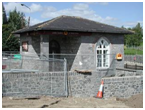 |
|
12000008 |
Saint Francis's Abbey Brewery, Horse Barrack Lane (off), Kilkenny, County Kilkenny |
1870 - 1880 |
Architectural | Regional |
Building Misc |
A pleasant modest-scale range also known as "The Sample Rooms" contributing to the group and setting values of the Saint Francis's Abbey complex which has undergone extensive redevelopment over the course of the twentieth century to accommodate an expanding brewery. Detached three-bay single-storey Gothic-style building, c.1875, possibly incorporating fabric of medieval abbey, founded 1231-4, with two-bay single-storey recessed lower entrance bay to left. Pitched slate roofs with clay ridge tiles, and cast-iron rainwater goods. Random rubble limestone walls with cut-limestone quoins to corners. Paired round-headed window openings with cut-limestone flush sills, cut-limestone block- and-start surrounds having chamfered reveals, and fixed-pane fittings having leaded panels. Pointed-arch door opening with cut-limestone block-and-start surround having chamfered reveals, and timber panelled door. Set back from road in shared grounds. |
250561, 156294 |
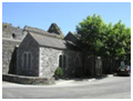 |
Appendix G – Conservation Drawings